2002:0389 - DERRY: Oakgrove Integrated College, Gransha, Derry
County: Derry
Site name: DERRY: Oakgrove Integrated College, Gransha
Sites and Monuments Record No.: N/A
Licence number: AE/02/76
Author: Robert M. Chapple, for NAC Ltd.
Author/Organisation Address: 19 Irwin Drive, Belfast BT4 3AR
Site type: Burnt mound and Pit
Period/Dating: Prehistoric (12700 BC-AD 400)
ITM: E 646011m, N 919916m
Latitude, Longitude (decimal degrees): 55.024667, -7.280419
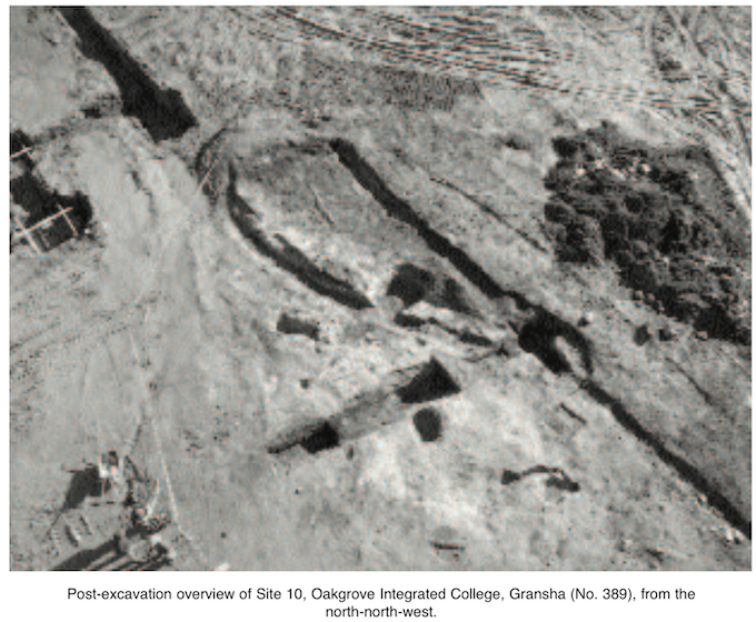
The site of the new Oakgrove Integrated College lay on the outskirts of Derry, on the eastern, ‘Waterside’ bank of the River Foyle, with the historical centre of the city c. 4km to the south-west. The building footprint for the school consisted of an area of c. 9500m2 within a development site of c. 16ha. Monitored topsoil-stripping revealed twelve areas of archaeological potential. All were investigated, although only three revealed traces of ancient activity. Excavation took place intermittently between June and November 2002.
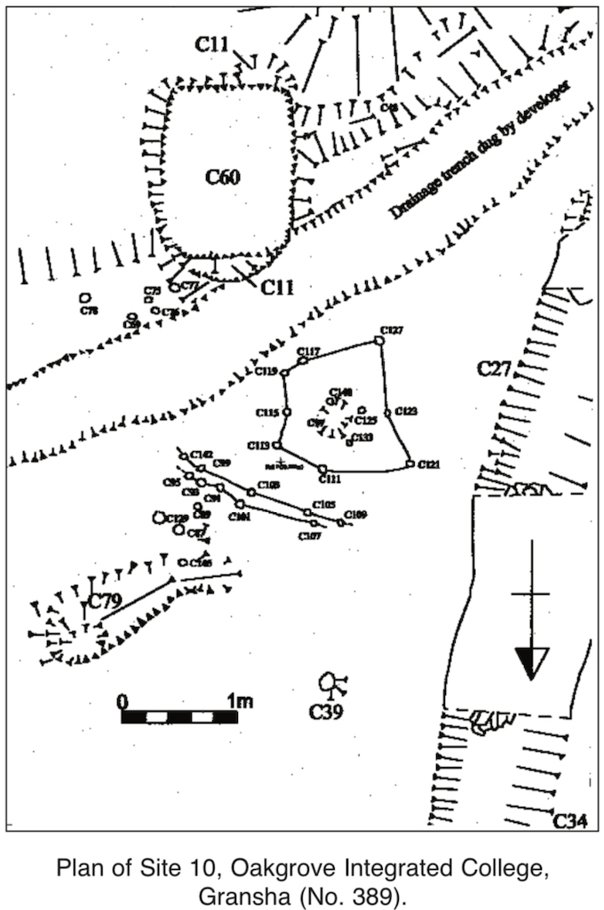
Site 10: burnt mound
The central part of this site was dominated by a trough, C60, a subrectangular pit with steeply sloping sides and a flat base (1.82m by 1.31m by 1m deep). This feature was filled with a compact, black/grey, sandy silt, containing frequent fire-cracked stones and charcoal flecks, which was recut by C11, a subrectangular pit with gently sloping sides and a generally flat base (1.89m by 1.3m by 0.57m deep). C11 was not dug as deeply as C60, but it extended slightly further to both north and south, where it cut through subsoil. This led to the slightly ‘stepped’ appearance of the sides of the cut. This recut contained four fills. The lowest was a compact, light yellow/blue, sandy to clayey silt, overlain by a compact, black/grey, sandy silt that contained frequent charcoal flecks and small stones. This was overlain by a loose, blue/grey, silty sand, under F5, a compact, black, sandy silt with extensive, small, fire-cracked stones and frequent charcoal flecks (c. 14.14m by c. 5.86m by 0.35m deep). This layer extended beyond the confines of the C11 recut and covered large parts of the site. The trough was recut again, by C13, a subrectangular pit with sloping sides and a flat base (2.19m by 1.43m by 0.81m deep). C13 cut F5 and contained six fills. A compact, light brown/yellow silt that contained occasional small stones was overlain by a loose, mottled, light blue/grey to brown, sandy silt that contained frequent stones. This was overlain by a compact, dark grey/brown, silty sand that contained occasional small stones and was itself overlain by a compact, dark brown/black, silty sand containing frequent charcoal flecks and fire-cracked stone. This was overlain by a compact, dark orange/brown, peaty, clayey silt containing occasional small stones, which was overlain by a loose, mottled orange/ brown, sandy silt.
Much of the subsoil surface had suffered sustained and intense burning, changing its appearance to a grey/white silty sand. Stratigraphically, this activity could be seen to be related to the C11 recut of the trough. Although the fills associated with the C60 trough and the C11 recut all appeared to be related to burning activity traditionally associated with burnt mounds, most of the fills of the C13 recut appeared to be relatively light in colour and composed of variants of sands and silts. Thus it appeared that, although C13 was recut into an existing trough, it was never used and was allowed to fill naturally with silty sediment. The peaty texture of the uppermost layer in this cut may indicate that C13 eventually became a small stagnant pool before reaching its final level.
To the north of the trough a series of 30 stake-holes was discovered. Stratigraphically, these appeared to date to the earliest (C60) phase of activity and were no longer in existence by the time of the C11 recut. Though fragmentary, they may be tentatively reconstructed to form two lines of a possible windbreak and a possible structure surrounding the C97 pit.
A possible secondary trough (C40) lay to the north-west of C60. This feature was a subcircular pit with steeply sloping sides and a flat base (0.92m by 0.88m by 0.31m deep). It was filled by F41, a loose, dark/medium grey, silty sand containing frequent large stones. As burnt-mound sites appear to have commonly reused boiling-stones (leading to their fragmentation), the recovery of larger stones from this pit suggests that they had been used only a small number of times. As F41 was sealed by F5, it may be contemporary with the earliest, C60, activity, pre-dating the C11 recut.
Site 11: pit group
This area measured 8.97m (north–south) by 8.2m (73.58m2) and lay near the crest of a north-east/ south-west-running ridge, providing good views toward the River Foyle in the west and Lough Enagh (Western) in the south-east. Initial cleaning of the subsoil surface revealed four pits.
C500 was an irregularly shaped pit with a flattish base (0.81m by 0.61m by 0.09m deep). This feature cut the shale bedrock and contained a firm to compact, dark black/brown, clayey silt with occasional charcoal flecks and frequent large stones. This fill produced sixteen sherds of prehistoric pottery. C501 was a subcircular pit with a concave base (0.91m by 0.87m by 0.21m deep). This feature cut the shale bedrock and contained three fills. F504 was a firm to compact, mid-brown silt containing frequent large stones and charcoal fragments. This fill produced one piece of struck flint and six sherds of prehistoric pottery. It was overlain by a compact, black, burnt, charcoal-rich, sandy silt containing frequent small stones. This fill produced one piece of flint debitage, 127 sherds of prehistoric pottery and a quantity of carbonised hazelnut shells. It was overlain by a firm to friable, mid-brown silt that contained frequent charcoal flecks and produced one sherd of prehistoric pottery. C502 was a subcircular pit with an east–west-sloping base (0.62m by 0.5m by 0.06m deep). It cut the subsoil, was filled by a compact, black, sandy silt with a high charcoal content and contained one large stone. C503 was an irregularly shaped pit with a pointed, V-shaped base (0.74m by 0.44m by 0.14m deep). It cut the shale bedrock and was filled by a loose, black/orange to yellow/brown mixture of natural and burnt material containing frequent small stones. It produced a flint scraper and one sherd of prehistoric pottery.
As expert analyses of the pottery and flint assemblages have yet to be undertaken, it is too early to make definite comments on the date and function of this collection of pits. However, it is clear that they did not hold a series of structural posts or form a unified construction. The carbonised hazelnut shells recovered from the C501 pit, coupled with the presence of both flint and pottery, are increasingly commonly recognised as relating to Neolithic cremation pits. The lack of human bone from these features may be explained by the acidic nature of the underlying shale bedrock, although it is hoped that pH testing of the soil samples will confirm whether this theory is correct.
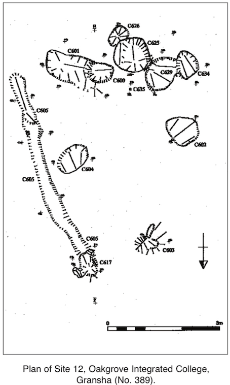
Site 12: pit group
Site 12 lay c. 42m south-east of Site 11 and measured 7.3m (north–south) by 6.37m (46.54m2). On investigation, nine pits and ancillary features were identified. C600 was a circular pit with a rounded base (0.69m by 0.55m by 0.33m deep). It contained a firm, dark brown/black, sandy silt with occasional small stones and frequent charcoal flecks. This was overlain by a compact, mid- to light brown, silty sand and was under a firm, light to mid-brown, slightly clayey silt containing occasional small stones and charcoal flecks. The last fill also extended into C625, C629 and C634. C601 was a subcircular pit with a rounded, U-shaped base (0.9m by 0.79m by 0.31m deep). This feature cut the subsoil and was filled by a firm to friable, mid-brown, sandy, clayey silt that contained frequent charcoal flecks, small and large shale fragments and two large stones and produced one sherd of prehistoric pottery. This was overlain by a firm, mid-yellow/brown, sandy, clayey silt that contained frequent charcoal flecks and was overlain by a soft to friable, dark brown/black, sandy silt containing frequent charcoal flecks and occasional shale fragments. C602 was a subcircular pit with a rounded base (0.95m by 0.75m by 0.17m deep). This feature cut the subsoil and was filled by a loose to friable, dark brown/black, sandy clay that contained charcoal and occasional large stones and produced one sherd of prehistoric pottery. This was overlain by a compact, mid-orange/brown, gritty silt containing fine shale inclusions and frequent small stones. C603 was an irregularly shaped pit with an irregular base (1.2m by 0.63m by 0.15m deep). This feature cut the subsoil and was filled by a firm, mid-yellow/brown, clayey silt containing occasional charcoal flecks. This was overlain by a friable, mid-brown, gritty silt containing occasional charcoal flecks, frequent fine grit and stones of various sizes. C604 was an oval pit with a flattish base (0.8m by 0.7m by 0.21m deep). This feature cut the subsoil and was filled by a loose to friable, mid-orange/brown, clayey silt that contained frequent charcoal flecks and produced eight sherds of prehistoric pottery. This was overlain by a loose to friable, black/brown, sandy silt containing a high proportion of charcoal and frequent small stones. A quantity of carbonised hazelnut shells and ten sherds of prehistoric pottery were recovered from this fill, which was overlain by a firm, light orange/brown, clayey silt containing occasional charcoal flecks.
C626 was an oval pit with an irregularly shaped base (0.61m by 0.43m by 0.24m deep). This feature cut the subsoil and was filled by a compact, mid-brown, sandy, clayey silt containing occasional charcoal flecks. This was cut by C625 along its north-western edge. C625 was a circular pit with an irregularly shaped base (0.98m by 0.97m by 0.22m deep). It contained a firm, black/brown, clayey silt that contained a high proportion of charcoal, large stones and 54 sherds of prehistoric pottery. C629 was a subcircular pit with an irregularly shaped base (1.06m by 0.77m by 0.3m deep). It contained a loose to friable, black, silty clay that contained a high proportion of charcoal and produced two crumbs of prehistoric pottery. C634 was conjoined at its eastern edge with C629. This feature was an oval pit with a U-shaped base (0.71m by 0.57m by 0.45m deep). During excavation no indication of a cutting plane could be discerned between these two features. Both appeared to share the fill F628, overlain by F631 and F607. Within C634 a struck flint was recovered from F631.
C605 was a linear gully with a concave base (5.14m by 0.44m by 0.3m deep) running south-south-east/north-north-west along the eastern extremity of the site. This feature contained a loose to friable, light yellow/brown, clayey silt with fine grit and large shale stones. This was overlain by a firm to sticky, black/brown, clayey silt that contained frequent patches of charcoal, shale fragments, large stones and two sherds of prehistoric pottery. At the northern end of the gully this silt was overlain by a firm, black, silty clay with concentrated patches of black charcoal. At its northern end the gully terminated in a subcircular post-hole with a concave base (0.68m by 0.48m by 0.35m deep). This feature appeared to be contemporary with C605 as both were filled by F612.
It is difficult to ascribe a function to this collection of features. With the exception of the post-hole, no evidence of structural members was recovered. The broad, laminated fills of the excavated pits precluded their interpretation as a series of receptacles for structural timbers. In broad terms, the association of pottery, worked flint and hazelnuts, as well as the absence of cremated bone, has parallels with the Site 11 pit complex. The interconnectedness of pits C600, C625, C629, C634 and C635 is difficult to explain. These pits may have been dug in rapid succession and partially filled with identical fills, but it is also possible that they represent a punctuated sequence. In the latter case, their lines of cut have become indistinguishable owing to the identical nature of the materials used to fill them. At present, definite statements of neither date nor function may be reliably made. However, a preliminary examination of some of the unwashed pottery from this site suggests a date in the Neolithic period.