2002:0194 - MOUNT (BGE 3/28/1), Clare
County: Clare
Site name: MOUNT (BGE 3/28/1)
Sites and Monuments Record No.: N/A
Licence number: 02E1149
Author: Kate Taylor, Margaret Gowen & Co. Ltd.
Author/Organisation Address: 2 Killiney View, Albert Road Lower, Glenageary, Co. Dublin
Site type: Settlement cluster
Period/Dating: Modern (AD 1750-AD 2000)
ITM: E 527798m, N 665162m
Latitude, Longitude (decimal degrees): 52.732721, -9.069058
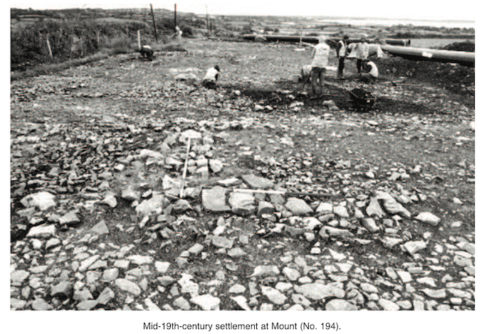
This site was examined as part of the Bord Gáis Éireann Pipeline to the West project. An area measuring 96m by 15m was investigated just below the brow of a hill, on a north-east-facing slope overlooking the Shannon Estuary. Monitoring of topsoil-stripping had identified a large area of apparently structural limestone adjacent to a small road. Once cleaned, it became clear that the stone represented the remains of three buildings, a cellar and various associated yards and gardens. These corresponded with structures recorded on the first-edition (1842) OS map of the area.
It was decided that as much as possible of the site would be preserved in situ. Therefore only the strip that was to be destroyed during pipe-trench construction was fully excavated. The area to be preserved was recorded and then covered with a geotextile membrane and a layer of soil.
The fully excavated area showed little vertical stratigraphy, and it is considered that just two phases of activity were represented: the construction of the buildings and the rubble from their demolition or collapse. Much of this rubble was removed to provide a clearer plan of the buildings.
Structure A, a long, three-roomed building, typical of vernacular architecture in the west of Ireland, was at the top of the hill, adjacent to the townland boundary wall. The wall foundations were of limestone blocks, and there were large spreads of sand and crushed shell mortar. A neatly cobbled floor survived in the eastern room.
Two areas of cobbling were evident to the north of Structure A. The surface nearest to the building was composed of small cobbles and probably represented a household yard, while that farther north was a large area of bigger stones, which was more likely to have been a farmyard.
Structure B lay below a thick spread of rubble at the edge of this larger yard surface and was a small cellar or cold store. It had internal dimensions of 1.5m by 1.3m and was 0.95m deep. One side of the cellar was cut into the edge of a bedrock outcrop; the others were lined with well-constructed limestone block walls.
Structure C, which was L-shaped, was in the centre of the site. The wall foundations were of limestone block construction, although a number of handmade bricks were included in the rubble overlying the foundations. It is likely that the walls were of mixed material, with perhaps door and window surrounds being of brick in predominantly limestone walls. The building was divided into three rooms, and a path, with kerbing dividing it from the large yard surface, ran along the southern wall of the building, leading to a doorway in the internal corner of the L. To the north of the building was another area of cobbling, consisting of small round stones.
Structure D was at the northern end of the site. The structure was probably C-shaped, with an open porch area partially revealed on the side facing the road. At the rear a path, flanked by narrow wall foundations or kerbing, ran from a laneway toward the back door. This building appeared to have been constructed primarily from handmade brick, with only occasional limestone pieces in the foundations.
To the north of Structure D was an area covered by a thin layer of fine gravel, possibly representing the location of a lawn. This was enclosed by a wall that was perpendicular to the road and joined the laneway to the rear of the buildings.
An enormous number of artefacts (nearly 3000) were recovered from the site; these have yet to be examined in detail, but particular items stand out. An assemblage of almost 1600 sherds of pottery includes a complete stoneware inkwell. A total of over 800 fragments of glass include window and bottle glass, the stem of a wine glass and a lens from a pair of spectacles. Of the nearly 30 clay-pipe fragments, one piece was marked ‘Limerick’. The almost 400 metal items include coins, nails and a door handle. A few personal items were found, such as a domino and a folding penknife. The material suggests relatively wealthy occupants, especially those living in Structure D, which produced a large proportion of the material. Several large bones from the cellar dominated the small assemblage of animal bone. Samples of bricks and mortar were also taken.
Research into the structures and their inhabitants is continuing. The 1842 OS map (surveyed in 1840) shows a collection of buildings that closely mirror the foundations recorded during excavation. The map also shows that the settlement had the name of Knockboy and that a chapel, since removed, stood on the opposite side of the road to the excavated structures.
It appears that few changes were made to the layout of the buildings as seen on the 1840 map before their abandonment and destruction or collapse, suggesting that they did not have a particularly lengthy period of use. Indeed the 1899 OS map (surveyed in 1894–5) shows an empty field, indicating that by that date the buildings were at the least in a severe state of ruination.
Examination of documentary evidence, including the 1825 tithe applotment, the 1855 Griffith Valuation and census information from the 19th century, shows that the population of Mount townland decreased dramatically at the time of the Great Famine of the later 1840s. It appears that by 1855, and probably before 1851, the buildings excavated at this site had been abandoned, if not demolished.
There is a contradiction between the apparent wealth of these households, particularly the people living in Structure D, which was brick built and produced a large quantity of relatively opulent artefacts, and its disappearance during the worst privations of the 19th-century famines. It seems unlikely that these individuals suffered from the extremes of poverty and starvation recorded for the district at this time; however, they may have faced financial problems or chosen to leave for other reasons.
At present it is not possible definitely to identify the occupants of the excavated houses, although the location of Structure D directly opposite the chapel is perhaps relevant. Sources indicate that in the early 19th century there was a hedge school in the chapel and that this was replaced in 1842 by the national school in nearby Ballynacally, perhaps prompting the teacher to relocate and abandon his house. It is hoped that further research will provide more information and allow the construction of a detailed history of this small 19th-century habitation.