2002:0122 - CAHIRACON (ED Rinealon) (BGE 3/37/7–9), Clare
County: Clare
Site name: CAHIRACON (ED Rinealon) (BGE 3/37/7–9)
Sites and Monuments Record No.: N/A
Licence number: 02E0952
Author: Emer Dennehy and Bruce Sutton, for Margaret Gowen & Co. Ltd.
Author/Organisation Address: 2 Killiney View, Albert Road Lower, Glenageary, Co. Dublin
Site type: Fulachta fia
Period/Dating: Prehistoric (12700 BC-AD 400)
ITM: E 522670m, N 655519m
Latitude, Longitude (decimal degrees): 52.645358, -9.142705
BGE 3/37/7
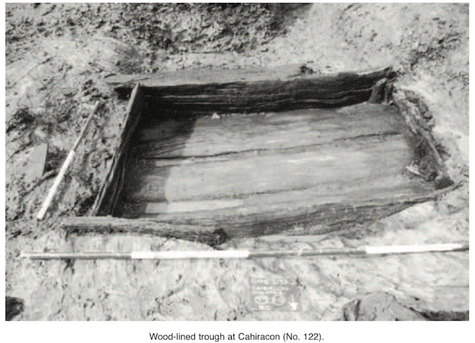
This site was exposed during monitoring of topsoil-stripping along the route of Section 3 of the Bord Gáis Éireann Pipeline to the West, which extended from Goatisland, Co. Limerick, to Gort, Co. Galway. The site was in the base of a shallow, elevated bowl valley within sight of the Shannon Estuary. The mound was horseshoe shaped, measuring 11.5m north–south by 10.75m, with a single rectangular timber trough. There were seven identified phases, with 64 contexts excavated.
A pre-fulacht build-up of peat constituted the initial phase on the site.
The construction of the trough was included in the second phase of site activity. It was made from split oak planks, with alder pegs hammered into the four corners to hold the side planks in place, and measured 2.3m east–west by 1.27m by 0.56m deep. A timber platform was constructed to the south of the trough. The trough was filled with water and was fed from a spring directly to the west. A thin layer of sand had been spread in the base of the cut, on which the base oak planks were laid.
A build-up of organic material in the fulacht mound marked the third phase and indicated that the site was abandoned for an indeterminate period of time.
In Phase 4 the trough was halved in size, with a sandstone platform being laid down in the western half. This signified a possible change in function and provided a stable work platform for the trough owing to the covering of the previous platform. There is no mound material from this phase within 2m of the trough in any direction, indicating a desire to keep the immediate work area clear.
The fifth phase of activity was identified by a hearth found on the eastern side of the mound above Phase 4 material. This phase encompassed a longer period of time than Phase 4, because of a larger accumulation of mound material. The trough was then filled with burnt wood in a deliberate and symbolic act, ending site use.
The final two phases of the history of the site comprised the build-up of post-fulacht peat and modern disturbance such as gravel field drains. Pending radiocarbon results for the alder pegs from the trough will provide a date for the construction of the trough and therefore an initial date for site activity. Further analysis of the redeposited burnt wood will give a date for the final use of the area.
BGE 3/37/8
On the north-facing cusp of a low-lying hill 180m downslope from fulacht fiadh BGE 3/37/7 (above), this site sloped east–west and had restricted views in all directions bar north. The fulacht fiadh consisted of a D-shaped compact mound of heat-shattered sandstone, limestone and ore residue in a charcoal-enriched matrix overlying an L-shaped trough. Five phases of use were identified. The mound measured 9.3m north–south by 4m, with an average depth of 0.3m. The ground level of the natural beneath the mound appeared to have been deliberately reduced to provide a contained work area/surface for the fulacht fiadh. Excavation of the site indicated that the mound extends eastward beneath the sod and outside the limit of the Bord Gáis wayleave.
Phase I concerned the trough, which was originally L-shaped, measuring 2.5m north–south by 1.7m, with an average depth of 0.72m. Only one episode of activity can be directly related to the trough at this stage and consisted of burnt material and ore by-products, illustrating the use of the site specifically for metalworking activities.
Phase II started with the recutting and shortening of the trough. The trough was shortened using slate flags to define the edges; it is now linear with rounded terminals, measuring 1.8m north– south by 1m. The trough was lined with charcoal and fired to considerable heat, resulting in the scorching of the flags. After this use the trough was backfilled and abandoned.
Phase III began with the excavation of a large pot-boiler (0.8m by 1.15m by 0.25m) through the eastern protrusion of the original, L-shaped trough. It contained a single fill of 40% burnt sandstone in a black silt–clay matrix. This was also the main mound deposit, indicating that the period of use of this pot-boiler was quite substantial.
Phase IV was an abandonment phase illustrated by sod regrowth.
Phase V consisted of alternate layers of burning and smelting within the mound and was not associated with any of the cut features.
It appears that this fulacht fiadh would have fulfilled an industrial purpose related to metalworking activities. It is clear that the original use of the trough posed difficulties and problems to the user community, resulting in the necessity to shorten the trough and line it with stones. By reducing the size of the trough and limiting the area of the fire, a more intensive channelling of the heat source would have been achieved, providing better working conditions. At no point would the site have fulfilled a domestic purpose, and at no point would either the trough or the pot-boiler have retained water.
BGE 3/37/9
A fulacht spread was identified 24.8m to the north of fulacht BGE 3/37/7 (above); this was interpreted to be displaced material from Phase 4 of BGE 3/37/7.