2002:0082 - BALLYCORICK, Clare
County: Clare
Site name: BALLYCORICK
Sites and Monuments Record No.: N/A
Licence number: 02E1186
Author: Brian Halpin, for Margaret Gowen & Co. Ltd.
Author/Organisation Address: 2 Killiney View, Albert Road Lower, Glenageary, Co. Dublin
Site type: Fulacht fia
Period/Dating: Prehistoric (12700 BC-AD 400)
ITM: E 528496m, N 666835m
Latitude, Longitude (decimal degrees): 52.747854, -9.059077
BGE 3/25/2
Topsoil-stripping on the Bord Gáis Éireann Pipeline to the West uncovered a large fulacht fiadh in Ballycorick townland, Co. Limerick. A large mound of heat-shattered stone with a charcoal-rich fill was encountered. On the surface of the mound a stone-lined cavity was unearthed, measuring 0.82m east–west by 0.65m with a maximum depth of 0.25m. It was a subrectangular U-shaped pit lined with unworked stone flags on the base and sides. It may have been funerary in nature or used as a storage pit.
A section through the mound revealed numerous fills representing different episodes of firing related to a double trough that was uncovered in the east quadrant. These troughs, 4.1m north–south by 3.1m with a maximum depth of 0.48m, had originally been one large trough later cut into by a second trough. They were shallow subcircular features with burnt material throughout, and they continuously filled with water as they were excavated.
The south-western area of the site contained a large assemblage of randomly dispersed stone lying on and just below the surface of the mound. These stones were seen as remnants of a post-medieval field boundary, evident on either side of the site. A roughly subcircular large depression/pit, measuring 10.2m north–south by 9m, with a minimum depth of 1.85m, was found; it had steep edges to the north, east and south and a slightly more gradual slope to the west. This feature was seen as a natural depression/sinkhole in the yellow/orange silty clay subsoil, which was well below the water table, making excavation extremely difficult. Though a natural depression, it appeared to have been further shaped, evident in the almost vertical nature of three of the four sides. It is possible that this shaping was carried out to facilitate access to the feature for the retrieval of water, either for drinking or for working the trough.
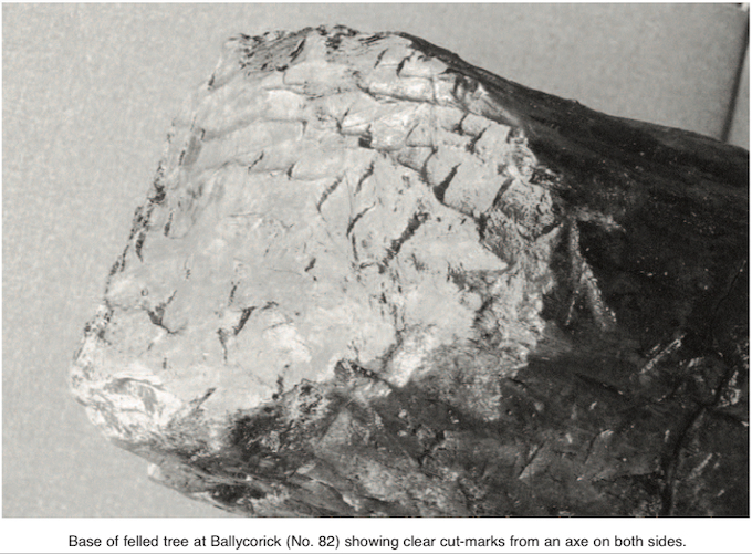
At some point the continual firing of the trough was abandoned and this feature was filled in with burnt material. This was interpreted as an episode of deliberate deposition of waste material. Large amounts of hazelnuts and wood debris were recovered from the feature. A large unworked timber was found in a very good state of preservation. Lying directly below this timber were the remains of a felled tree 4.75m long, with remnants of branches remaining. The base of this tree showed clear cut-marks from an axe on two sides of the trunk. These marks have been preserved intact, and the signatures from the individual axe cuts are clearly visible. It is possible that the tree and debris were deposited in this feature to form a platform for further trough activity or possibly to accommodate retrieval of water from a precarious position within the feature.
Unfortunately the full recording of the base of this feature was not possible because of the large amounts of groundwater involved. An order was issued from the Bord Gáis Éireann health and safety officer to abandon all works owing to safety concerns relating to the depth and wet conditions of the pit. Specialist reports are forthcoming.
BGE 3/25/3
A second fulacht fiadh was uncovered 120m to the east of the above site. This burnt mound was found intact in the line of the pipeline corridor. The monument comprised a small mound of charcoal-rich material with heat-shattered stone in a kidney shape encompassing an area measuring 7m north– south by 5.25m. The mound was sectioned, which revealed a distinct layer of firing from the trough. The trough, measuring 1.64m north–south by 1.4m, was 0.2m deep, subrectangular and generally U-shaped with steep sides; it showed evidence of a later recut of a second subrectangular trough imposed perpendicular to the initial cut.
In the south-western part of the mound was an area of densely compacted pebbles and small stones representing a metalled surface. This may be indicative of a production area associated with the mound. Minor amounts of what is believed to be slag were recovered just above this feature. This metalled surface overlay the subsoil and had minor charcoal flecking throughout; it was interpreted as contemporary with the period of trough activity. No finds were recovered. Specialist reports are forthcoming.