2001:1399 - KILMICHAEL, CO. WEXFORD,, Wexford
County: Wexford
Site name: KILMICHAEL, CO. WEXFORD,
Sites and Monuments Record No.: SMR WX007B001
Licence number: E1186
Author: PATRICK POWER
Author/Organisation Address: —
Site type: Early Bronze Age graves
Period/Dating: —
ITM: E 725510m, N 666395m
Latitude, Longitude (decimal degrees): 52.734058, -6.141506
Introduction
In early 2001 two edge-set stones were noticed eroding out of a cliff face at Kilmichael Point, on the border between counties Wicklow and Wexford. Local people reported the find to the NMI and the National Monuments Service.360 The two stones protruding from the cliff face at a depth of 1.2–1.5m below ground level were the only indication of a structure and were thought to be a stone-lined drain. The site was not investigated by the NMI at this time. A number of months later, as the stones were in danger of collapsing, the area was investigated by local historian Mr Patrick Power, assisted by Mr Fiachra Ó Lionáin, Mr Brian Byrne, Fr Eugene McCarney, Mr Peter O’Toole, Mr Shane Kinsella and Mr Pat Kinsella, and was found to be a short cist. According to Mr Power’s report, an attempt had been made by others to excavate the cist some months earlier and this had contributed to the disturbance of the site. This report is based on the account prepared by Patrick Power and his collaborators. Partly owing to the nature of the site it was not possible to draw either a plan or a section of the grave.
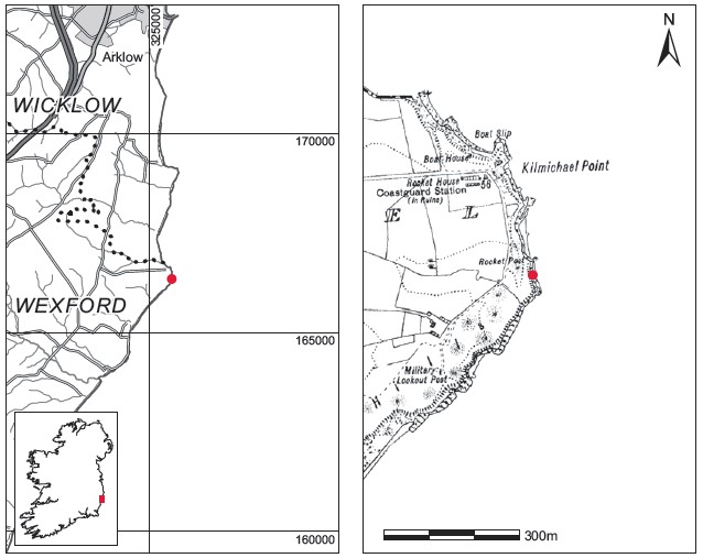
Location (Fig. 3.223)
The cist was in Kilmichael townland, near Castletown, Co. Wexford,361 on a cliff over 12m high, which was being actively eroded. The site was approximately 500m south of Kilmichael Point, at an altitude of 0–15m above sea level. No sites of early Bronze Age date are known from the immediate vicinity of the site, but a polygonal cist containing a vase urn was excavated in 2001 at Kilmurry, some 9km to the south-west (this volume, pp 586–93).
Description of site
The cist was rectangular in plan, with its long axis aligned east/west. The eastern end stone of
the cist did not survive, but the remaining portion was approximately 1m long by 0.6m wide
by 0.6m high internally. One large side stone was visible at the northern side and a second at

Fig. 3.223—Location map, Kilmichael, Co. Wexford.
the southern side. Both side stones were roughly rectangular in shape and inclined inwards at the top, probably as a result of the erosion of the surrounding soil. The southern side slab appeared to be substantially larger than that at the north. The western end of the cist does not appear to have been fully exposed, but photographs of the cist interior suggest that it was formed, at least in the upper levels, of stones laid flat. The floor of the cist was not paved with stone but was apparently formed of marl. The cist was not covered by a capstone, but it is possible that this was lost owing to erosion of the bank of soil above the cist. A number of smaller stones found in the cist fill are thought by the finders to have covered the cist. Some packing stones were also found around the outside of the cist walls.
The cist contained a ribbed bowl and three pieces of worked flint, but no human remains were recovered. It had been filled with a large quantity of sand and vegetation, but small quantities of ash were found throughout the compacted material towards its base. The flint fragments were found within this layer also. The bowl was discovered underneath a large pebble towards the centre of the cist. A number of quartz pebbles were also found in the cist fill.
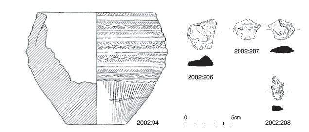
Ribbed bowl, 2002:94 (Fig. 3.224)
The vessel is a ribbed bowl (Ó Ríordáin and Waddell 1993) with three plain ribs, a slightly inward-sloping rim and a flat base. The lower part of the body has been eroded, probably through contact with the sand in the cist. One part of the bowl is eroded to the level of the lowest rib. These areas reveal a fine fabric with large micaceous grits. The rim is eroded in several areas, resulting in partial loss. It may have been decorated but owing to wear this is unclear, although some decoration in the form of nail or other impressions can be seen. Externally, the rim is decorated by a single row of obliquely incised lines. Below this are two

Fig. 3.224—Ceramic vessel and flints, Kilmichael, Co. Wexford.
grooves forming a raised line, below which is a running chevron in false relief bordered by two rows of obliquely incised lines, slanted in opposite directions. Below this again two grooves form a raised band decorated with obliquely incised lines. The first rib is just below the lower groove. The running chevron motif described above is repeated between the first and second and between the second and third ribs. Two grooves below the third rib form a wide band decorated with obliquely incised lines. Below this is a slightly raised band decorated with a running chevron, below which is a similar band of ornament. The decoration on the lower part of the vessel consists of two bands of long incised lines separated by a single running chevron. Much of this area is obliterated by the erosion on the surface described above.
Dimensions: H 11.9cm; ext. D rim 12.65cm; ext. D base 6.09cm; T 0.94cm.
Lithics (Fig. 3.224)
Flint flake, 2002:206
Flint flake, probably débitage, red-brown in colour. The bulb of percussion is prominent and the striking platform is also visible. Part of the cortex can be seen on one side of the flake.
Dimensions: L 3.1cm; W 2.95cm; T 1.1cm.
Flint flake, 2002:207
Flint flake, probably débitage, grey in colour. The cortex is visible on the outer part of the flake and a number of flake scars are visible on the outer surface.
Dimensions: L 2.85cm; W 2.15cm; T 0.95cm.
Flint flake, 2002:208
Flint flake, probably débitage. The cortex is visible on the edge of the flake and flake scars can be seen on the outer surface. No striking platform is visible.
Dimensions: L 2.6cm; W 1.45cm; T 0.45cm.
Comment
Owing to the way in which the site became exposed on the cliff face, it is probable that any human remains present would have been disturbed and fallen from the exposed end of the cist to the bottom of the cliff. Hence there was no bone or charcoal available for dating. The vessel is a ribbed bowl that conforms in form and decoration to stage 3 of Brindley’s (2007, 247–8) development of the bowl tradition, which is dated to between c. 1980 and 1920 BC.
360. Department of Arts, Heritage, Gaeltacht and the Islands.
361. Parish of Kilgorman, barony of Gorey. SMR WX007B001——. IGR 325588 166354.
