2001:1242 - SHANDON, Dungarvan, Waterford
County: Waterford
Site name: SHANDON, Dungarvan
Sites and Monuments Record No.: N/A
Licence number: 01E0327
Author: Emer Dennehy, Eachtra Archaeological Projects
Author/Organisation Address: Ballytrisnane, Old Parish, Dungarvan, Co. Waterford
Site type: Habitation site
Period/Dating: Medieval (AD 400-AD 1600)
ITM: E 625384m, N 594069m
Latitude, Longitude (decimal degrees): 52.097956, -7.629505
Monitoring of topsoil clearance to accommodate the construction of 40 UDC houses (Area 2) was undertaken at the above site by Stuart Elder (see No. 1241, Excavations 2001, 00E0442 ext.). Five areas of archaeological potential were identified during the course of this monitoring and these were excavated/recorded and tested under the present licence.
Located in the vicinity of house sites 35–38, Area 2A consisted of a group of nineteen shallow pits and stake-holes. No formal structure was identified.
In Area 2B, upslope of Area 2A, a small semicircular structure was excavated. The structure appeared to function in tandem with a work area used for the initial smelting/reduction of iron ore. On cessation of use the structure had been completely dismantled and the smelting-pits were backfilled.
Located 20m to the south-east of Area 2B, Area 2C contained a large rubbish-pit and an associated stake-hole. The pit was subcircular in plan, measuring 1.35m east–west by 0.87m in depth. It contained alternate layers of shells, fish and animal bones.
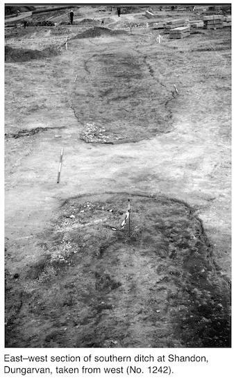
Located on the crest of a hill, the enclosure was identified as a rectangular platform enclosed by a large ditch. The northern portion of the site had been destroyed through quarrying activities in the 18th and 19th centuries. A large number of finds from the Shandon area (derived through quarrying activities) were submitted to the National Museum in the 1930s; it is possible that they were found during the destruction of the northern portion of the enclosure. The enclosure had surviving external dimensions of 90m east–west by 40m. It was not excavated but four internal pits were sectioned and the ditch was also sectioned in three places.
The ditch had an average width of 4m and depth of 1.2m. It had filled in gradually, predominantly through slippage of bank material and through its use for the disposal of rubbish. Several hearth sites within the ditch were also identified; the ditch terminals were filled with oyster shells. No evidence for the bank currently survives. All of the excavated pits contained animal/fish bones, indicating that they functioned as rubbish-pits. An iron-working area was also identified but not excavated. The initial cleaning of this area identified iron pins and a copper ingot. It would appear that the initial smelting of iron took place outside the enclosure in Area 2B, with the production of fine objects occurring within the protective confines of the enclosure.
The western limits of the enclosure were not identified during monitoring. An L-shaped test-trench measuring 40m east–west by 20m with an average width of 5m was excavated along the north-western boundary of the development site. During the excavation of this trench the western enclosure ditch as well as five charcoal-enriched pits averaging 1m in diameter were identified.
An additional archaeological area was identified to the immediate south of the enclosure, but was not investigated under the present licence.
The name Shandon is believed to be derived from sean dún or ‘old fort’; it would appear that the location of the enclosure from which the townland gets its name has now been identified.