2001:1042 - RATOATH, Meath
County: Meath
Site name: RATOATH
Sites and Monuments Record No.: N/A
Licence number: 01E1173
Author: Finola O’Carroll, Cultural Resource Development Services Ltd.
Author/Organisation Address: Campus Innovation Centre, Roebuck, University College, Belfield, Dublin 4
Site type: Historic town
Period/Dating: Multi-period
ITM: E 701779m, N 751795m
Latitude, Longitude (decimal degrees): 53.506290, -6.465680
During December 2001 Meath County Council inserted a water sewer and electricity cables along the Kentstown road, Ratoath, running through the area of archaeological potential for the town. The site was located along the northern (Kentstown) approach road arriving into the centre of Ratoath village. It was considered significant as it ran well within the medieval town of Ratoath, which is defined as a zone of archaeological potential and is bounded by the site of the medieval borough. The road also divides the motte from the old church and cemetery, two of the most important elements of the medieval town. Monitoring took place for the entire duration of the groundworks and revealed a number of features of archaeological significance. Among these were a late medieval open drain and associated laneway surface, a later area of rough cobbling, a cistern-type structure, a substantial ditch possibly representing the town boundary, a small V-shaped ditch, an 18th/19th-century wall foundation and a further ditch of unknown date.
The stratigraphical deposits uncovered showed a dark, wet, grey natural clay which underlies a deep, dark brown natural clay. Above this sits a mixed dark grey deposit containing post-medieval material, which in turn underlies road foundation material. However, as soon as the apparent line of the town boundary is encountered the deposits change. A large dump layer appears, containing pottery and the odd piece of decayed wood, sitting between the brown natural below and the dark grey layer above.
Possible town ditch
The ditch occurs at a point in the road where the land, which rises coming into Ratoath, starts to flatten off. It consists of a lens of gravel 1.5m long and up to 0.2m in depth lying underneath 0.25m of road foundation material. Underneath the gravel is 0.2–0.25m of a dark grey/blue compact clay with stone inclusions and organic material, as well as bone, twigs and post-medieval pottery. This layer suddenly dips in unison with the gravel lens above, cutting into the dark brown natural below, reaching a depth of at least 0.6m at one point. The width of this ditch was undetermined but it was probably close to 1.5m. No finds were made within the ditch fill itself, although the layer of dark grey/blue compact clay contained post-medieval Chinese-pattern pottery and some broken tile/brick material. The ditch does not appear to coincide with the projected medieval borough property boundaries, but if, as is thought probable, it represents part of the main drainage ditch for the property plots it could date from the initial laying-out of the town (c. 1200).
Small V-shaped ditch (property boundary?)
A small V-shaped ditch was detected running across the existing road, cut into the dark brown natural clay layer at a 45º angle, reaching a maximum depth of 0.4m and being 1.3m in width. It is filled with a dark grey/blue compact clay layer. Finds all came from the fill layer and consisted of post-medieval pottery and butchered animal bone. Interestingly, this ditch occurs right on the projected boundary of the medieval borough, but is not of substantial size. Dating is uncertain.
Large ditch (property boundary?) and possible bank
A large ditch, 3.4m at its widest point, was uncovered. It runs across the road and continues towards the church and cemetery. The ditch was cut into the natural brown clay and has a mixed fill. Its exact depth is unknown. The natural was cut away a little further south again, giving a bank-like appearance. The ditch also occurs exactly at a point where a borough property boundary is projected. Only a small portion of this boundary exists today, that being the short stretch between the old churchyard wall and the road. Date uncertain.
18th/19th-century wall foundation
A clay-bonded wall foundation was uncovered running beside the modern graveyard wall. It is likely that the wall was constructed in association with the road (c. 1795).
Possible ditch/pit
A large pit or ditch (which cuts into part of the possible cistern) filled with a cess-like material was discovered. It cuts into the redeposited natural of the cistern, giving a later date (see below). A northern cut was not very apparent, other than that it is certainly at least 2m in width. Animal bone was well represented. Date is uncertain.
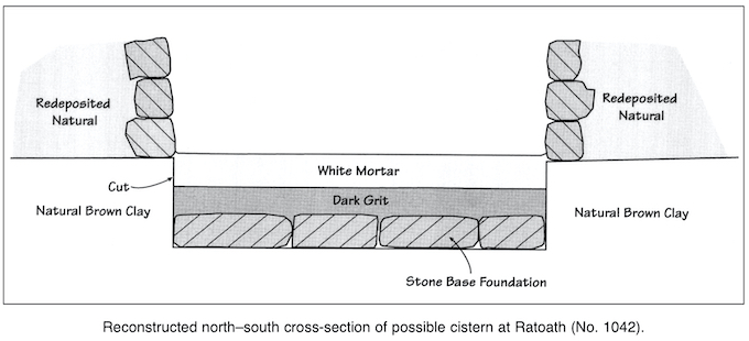
Possible cistern
A structure was uncovered consisting of two walls meeting at right angles to each other and containing a white mortar floor within. Both walls consisted of an internal facing of square-shaped stones, roughly 0.16m by 0.1m by 0.08m, giving a smooth vertical surface surviving to a height of three courses. The walls were clay-bonded and a substantial amount of clay was used as packing, giving an overall width to each wall of 0.5m. There was no external facing, giving the impression that the walls were not load-bearing. Within these walls there was a rock-hard base consisting of white lime mortar, 90mm deep, sitting on an equally hard layer of dark sandy grit, 60–70mm deep, which in turn sits on a base of large stones. This appeared to be a foundation for the floor base. The mortar rose up to the base of the first stone course, but rose higher in the corner where the two walls met. The walls were packed with clay, effectively sealing the structure, making it impermeable. It appears that sometime in antiquity the walls were collapsed inwards. The collapse was contained in a layer of very wet and soft mud, almost in liquid form owing to the presence of a continuous trickle of water. Finds were scarce except for the odd piece of animal bone. The exact nature of the structure is uncertain. Only a small portion of it was uncovered and excavated. It appears to have been constructed to hold a liquid of some form. The base was substantial, and not flat, allowing for a run-off of some sort. The careful clay packing, making the structure impermeable, strongly suggests a cistern. Indeed, the structure still held water, the primary fill being almost liquid in texture. The only finds associated with this structure came from the fill layers above. The primary fill did not produce any finds, while good post-medieval 18th/19th-century pottery was recovered above. It is certain, however, that the structure was destroyed sometime before the construction of the road.
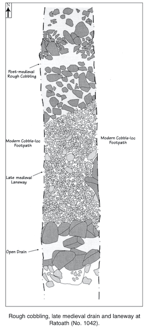
Area of rough cobbling of c. 17th-century date
Towards the junction with the main road of Ratoath, an area of rough cobbling was uncovered at a level 0.9m below the modern surface. The cobbles run for approximately 4m and appear to be set directly into the brown natural clay underneath. What survives of the surface is quite uneven; stones appear to have been disturbed right down the centre of the trench in antiquity and then not properly replaced. However, in places small areas of smooth metalled surfaces survive, fine gravel having been used to pack the cobbles. Broken slate fragments were also found walked into the surface, as were animal bones. The pottery recovered would appear to give a 17th-century date. The surface was not removed.
Late medieval drain and associated laneway surface
An open drain and associated laneway were uncovered at the end of the area of rough cobbling. The rough cobbling (see above) overlay the laneway surface. The laneway runs east–west and is bounded on the south side by a drain and on the north by a line of tightly packed large stones set into the brown natural clay. It is 2m wide and consists of a very smooth fine metalled surface, packed tightly down, of small flat pebbles. This surface runs up to the drain and is tightly packed into the walls, giving the impression that both are contemporary. To the north the surface does likewise to the line of tightly packed large stones. These stones act as a border to the laneway, set firmly in the brown natural clay. This area, and about a third of the laneway, were overlain by the rough cobble surface, which dates from a later phase. The laneway surface has produced late medieval pottery, without any later finds associated, as well as a metal knife blade. The drain runs west-east and consists of large uncut stones placed in a single line, to a height of three courses, and bonded in clay. The drain was 0.3m deep at the western end, draining to the east. The laneway surface does not continue beyond the open drain. These features were not destroyed and were left in situ.
Finds
The majority of the finds from the assemblage date from the late 18th century. However, a number date from as early as the 13th century, but were recovered in later disturbed contexts. A considerable quantity of butchered animal bone was recovered, along with some clay pipe fragments, glass and modern floor tiles. The pottery assemblage is largely composed of 18th-century, mostly English, wares. Quite a few sherds dating from the medieval period are also present, including Leinster ware and a sherd from Chester. The remains of a metal blade, possibly belonging to a knife, were found on the surface of the late medieval laneway. This artefact was heavily corroded and is currently undergoing conservation.