2001:869 - MELL 2, Louth
County: Louth
Site name: MELL 2
Sites and Monuments Record No.: N/A
Licence number: 00E0430 ext.
Author: Robert M. Chapple, for Valerie J. Keeley Ltd.
Author/Organisation Address: 19 Irwin Drive, Belfast BT4 3AR
Site type: Ring-ditch and Enclosure
Period/Dating: Bronze Age (2200 BC-801 BC)
ITM: E 705788m, N 776567m
Latitude, Longitude (decimal degrees): 53.728023, -6.396855
The site of Mell 2 was discovered by Kieran Campbell as part of monitored topsoil-stripping along the route of the Northern Motorway (see No. 881, Excavations 2001, 00E0282). Prior to its discovery, the site was unknown and presented no surface profile. An excavation licence was issued to Thaddeus Breen for the entirety of this site, which included the enclosures and a number of Early Christian graves. While the graves were excavated (Excavations 2000, No. 695), the ditched enclosures were left undug. This licence was later reissued to the writer for the two remaining ditched enclosures. This phase of the excavation took place between 23 February and 11 May 2001.
Mell 2 was situated c. 4.5km north-west of Drogheda town and c. 1.2km south-east of Tullyallen village. The surrounding area comprised open pastureland, which sloped gently to the west and south, falling gently into the valley of the River Boyne. The site lay at approximately 34.15m OD and possessed extensive views in all directions, especially into the Boyne river valley to the south.
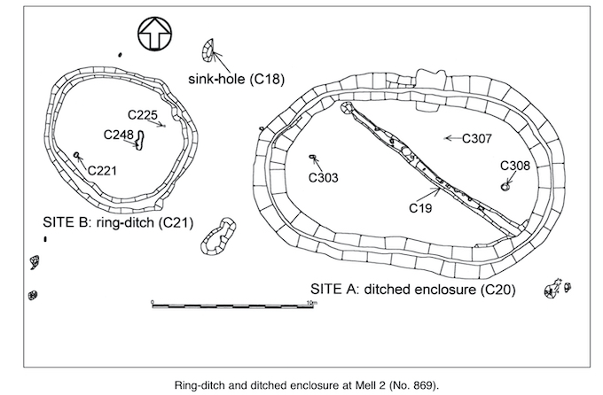
Site A: ditched enclosure
Site A comprised an annular ditch (C20) with rounded ends and parallel sides, enclosing a shallow ditch (C19) running diagonally across it along with two shallow post-holes (C303 and C308) and one stake-hole (C307). Externally the C20 ditch measured 19.26m east–west by 11.91m (15.67m east–west by 8.53m internally). In profile, C20 had steep, splayed sides and a narrow, rounded base. The average width of this ditch was 1.99m, with a mean depth of 1.65m. It contained 20 fills. The majority of these appeared to be various forms of redeposited subsoil which possessed very little charcoal content and produced few finds.
In the southern and south-western portions of Site A, a recut of the C20 ditch was noted. In profile, this cut appeared as a splayed ‘U’ shape with gradual sides and a concave base (11.26m x 1.5m x 0.55m deep). This recut contained six identifiable fills. Again, the majority of these fills were archaeologically sterile and appeared as redeposited subsoil. A second recut (C100) was visible in the south-western to south-eastern portions of the ditch. In section this recut appeared as a splayed ‘U’ shape with gradual sides and a concave base (32.35m x 1.1m x 0.69m) and contained some eight fills. The general character of these fills was dark and charcoal-rich, many containing quantities of burnt stone, struck flint and cremated bone. Where this bone was identifiable it was composed of both human and animal remains. The identified animal species included both pig and cattle. Through the north-western to south-western portions of the ditch a final partial recut was noted. In section, this recut appeared as a widely splayed ‘U’ shape with sides varying between steep and gradual and a concave base (29.18m x 0.87m x 0.4m). It contained nine fills. Again, the majority of these fills were dark and charcoal-rich and produced substantial quantities of burnt bone, coarse pottery, struck flint and carbonised hazelnut shells. One of these fills produced a decorated glass bead. Like the fills of the C100 recut, the skeletal material included evidence of both human and animal remains. With the exception of the phalanx of a juvenile pig, most of the animal bone could not be defined by species.
A long, shallow ditch (C19) ran diagonally across Site A. At its south-eastern corner it cut a fill of the C100 recut of the C20 ditch. From this point it ran north-west, where it terminated by the pit C310. C19 had sides which varied from steep to gradual with an undulating base (13.35m x 0.8m x 0.2m deep). This ditch contained a series of sixteen post-holes. Of these, two had evidence of posts burnt in situ. Inside the eastern and western arcs of the ditch two post-holes were also encountered.
While there is a difficulty in finding close morphological parallels for this site within the published literature, the general character of the pottery spans the period from the later early Bronze Age to the middle Bronze Age and appears to be derived from a number of large vessels with simply rounded or flattened rims (Anna Brindley, pers. comm.). However, it also appears that much of this material is in secondary, possibly derived, contexts.
Site B: ring-ditch
Site B comprised an annular ring-ditch and a number of internal features. The ring-ditch (C21) measured 9.14m in overall diameter (7.55m in internal diameter). In profile it had sides which varied from steep to shallow and had an irregular base. The average width of this ditch was 0.4m, with a mean depth of 0.45m; it contained twelve fills. These produced quantities of pottery, flint, possible slag, and both burnt and unburnt bone. In all cases the burnt bone could not be categorised as either animal or human. Although none of the unburnt bone could be categorised as to species, it was positively identified as animal.
Within the area enclosed by the ring-ditch were a shallow pit (C221) and a stake-hole (C225). Neither of these produced any finds and the fills of both were covered by F22, which is interpreted as the remains of the basal layer of an original mound, enclosed by the C21 ditch. In particular, C221 produced no indication that it had been prepared to receive human remains of any kind. F22 also covered C248, interpreted as a possible tree root, pre-dating the construction of the ring-ditch and its postulated internal mound.
The sink-hole
In the northern portion of the site a natural sink-hole was discovered. At the top this feature appeared as a suboval, measuring 1.47m north-east/south-west by 0.67m east–west. This narrowed to a curving shaft, 0.67m by 0.27m. The upper fill of this feature produced quantities of flint, pottery, slag and a fragment of a porcellanite axe. While none of the recovered pottery presented clearly diagnostic features, it appears that at least two vessels are represented, possibly of early Bronze Age date. This sink-hole is interpreted as a naturally occurring feature into which archaeological material became deposited. However, whether this deposition was a deliberate, ritualistic act or whether the sink-hole merely acted as a receptacle for occupational detritus is not possible to distinguish.