2001:705 - KILKENNY: John’s Bridge, Kilkenny
County: Kilkenny
Site name: KILKENNY: John’s Bridge
Sites and Monuments Record No.: N/A
Licence number: 01E0980
Author: Ian W. Doyle for Margaret Gowen & Co. Ltd.
Author/Organisation Address: 2 Killiney View, Albert Road Lower, Glenageary, Co. Dublin
Site type: Bridge and Pier/Jetty
Period/Dating: Medieval (AD 400-AD 1600)
ITM: E 650722m, N 655913m
Latitude, Longitude (decimal degrees): 52.652042, -7.250365
A limited programme of test excavation was carried out at John’s Bridge, Rose Inn Street/John’s Street, Kilkenny city, as part of the Kilkenny Flood Alleviation Scheme. The excavation trenches were on the bed of the River Nore and on the bank in the area around and under the modern-day John’s Bridge. This work took place during September and October 2001.
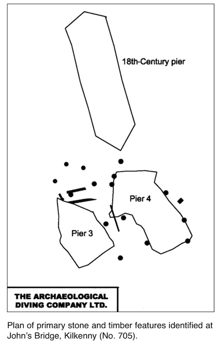
The River Nore, in Kilkenny city, is crossed at Rose Inn Street and John Street by a concrete bridge dating from 1910. This is the most recent bridge at this location. The remains of an earlier 18th-century bridge are located to the north of the existing bridge. Documentary references indicate a bridge at this location from the 13th century AD. Ongoing work by the Archaeological Diving Company (ADCO) has defined the remains of a masonry bridge which collapsed during a flood in 1763. The remains of at least two timber bridges have also been detected by the divers.
The weirs downstream of John’s Bridge were breached in July 2001, thus lowering the river level. The breaching, coupled with low levels of rainfall, insured that a portion of the west bank of the river at John’s Bridge was exposed and dry. The work carried out at John’s Bridge comprised the excavation of five trenches by hand on the west bank of the Nore. The Kilkenny Flood Alleviation Scheme entails an increase in the width and depth of the River Nore as it flows through Kilkenny. Present riverbed level at John’s Bridge is 40.5–41.75m OD. It is proposed to remove sediment to a depth of 38.9m OD across the river at this point.
Concern on the part of the consulting engineers as to the location of a main sewer line running under John’s Bridge necessitated the excavation of a series of trenches to locate the line of any such sewer and to determine its depth. Additional archaeological concerns required that these trenches be opened by hand, by archaeologists. It was also desirable to determine the presence or absence of archaeological material around and under the bridge. It was expected that such material would take the form of river gravels and silts containing archaeological objects and the remains of former bridge structures.
Trench 1, located directly under the modern-day bridge, revealed the line of the sewer. However, the remains of a masonry pier, referred to as Pier 1, were also revealed. As exposed, this measured approximately 3.6m north–south by 1.2m. The surrounding material was removed to reveal a depth of at least 0.3m for the pier. This pier was constructed of large to medium-sized roughly dressed blocks of limestone set into a well-bonded grey mortar. It is likely to relate to the bridge which was swept away in the great flood of 1763. Large amounts of collapsed masonry and debris were found immediately around the pier. A coin of George III was found associated with the collapsed masonry. A timber upright post was also revealed in this trench. Excavation ceased at that level.
Trench 2 was located on the northern or upstream side of the present-day John’s Bridge. This east–west-aligned trench was initially intended to find the northern line of the modern sewer. The greater part of Trench 2 was subsequently excavated into the gravels of the riverbed. A large cut filled with gravels and modern plastics and debris was detected. It is likely that this cut and fill, which extended some 3.7m out to the east from the sewer, is the backfill of a construction cut for the sewer. The eastern end of Trench 2 contained a deposit of loosely compact mid-greyish-brown stony river gravel, containing glass, metal, clay pipes, bottles, pottery, and in general modern detritus. Owing to flooding it was not fully excavated.
Two posts were also detected in the eastern end of Trench 2, protruding through the gravels. C209:01, a round-sectioned vertical post, had a diameter of approximately 0.15m and was exposed for a depth of 0.2m. The top of this post was encountered at 41.09m OD. C209:02, located slightly to the north, was more substantial with a diameter of 0.38m and was exposed for a height of 0.25m. Both of these posts remain in situ in the river.
The posts detected in Trenches 1 and 2 are likely to represent the remains of a temporary bridge erected in 1765 and removed in 1766. Additional posts, likely to be from this temporary bridge, have been detected by ADCO during underwater investigations towards the centre of the river.
Trench 3 was placed downstream of the present-day bridge and was also on the west bank. The purpose of this trench was to detect the continuation of the modern sewer main. Topsoil and sod covered the upper part of the trench to a depth of 0.3m, overlying some 1.3m of modern backfill and rubble. At a depth of 41.98m OD the modern cast concrete sewer was detected. Excavation ceased at that point.
Trench 4, placed upstream of the modern-day bridge, was excavated on the western side of the 18th-century bridge pier. The westernmost pier of the 18th-century bridge survives as a substantial elongated piece of masonry. A downstream cut-water is present, but the upstream cut-water appears to have been removed in antiquity. The pier survives to an approximate length of 11m north–south by 3.4m. A height of some 1.47m was exposed during excavation. The pier is constructed of large rectangular blocks of roughly dressed limestone varying in size from 0.5m to 0.3m in length. These are present in well-placed courses secured with a compact grey mortar and reinforced with iron ties. At the time of demolition, c. 1910, the pier was demolished to a level surface at 41.025–40.972m OD. Underwater excavation work by ADCO on the equivalent pier further to the east had discovered a form of timber shuttering thought to be associated with its construction. Accordingly, Trench 4 was directed towards ascertaining whether such a form of shuttering existed, or indeed survived, on the westernmost 18th-century pier.
Excavation within Trench 4 was feasible to a depth of 39.7–39.5m OD. At this depth water ingress hindered visibility. A compact layer of mortared masonry was revealed at the base of the trench. This consisted of a mass of mortar with occasional fragments of limestone breaking its surface. It is likely to represent a step in the foundation for the 18th-century bridge pier. The deposits in the upper part of the trench comprised gravels containing modern glass and pottery.
Further work is anticipated in 2002.