County: Kilkenny Site name: AYLWARDSTOWN HOUSE, Glenmore
Sites and Monuments Record No.: SMR 41:31 Licence number: 01E0075
Author: Ben Murtagh
Site type: House - 17th century
Period/Dating: Post Medieval (AD 1600-AD 1750)
ITM: E 666378m, N 622799m
Latitude, Longitude (decimal degrees): 52.352761, -7.025626
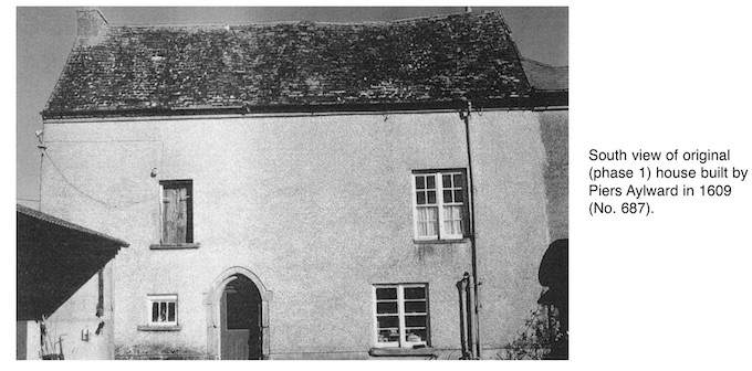
Testing was carried out at the north side of a three-storey house, built by Piers Aylward in 1609, in advance of the construction of a single-storey extension. The site is 1.4km from the west bank of the River Barrow and 1.6km south-east of the village of Glenmore in the south-east of the county. From the 14th to the mid-17th century it was the seat of a branch of the Aylward family. During the 18th and 19th centuries the 1609 building was extended. It forms a wing of what is now the main house. During the winter of 1999/2000 an archaeological survey was carried out on the upper part of the original building to facilitate the construction of a new roof.
The original house is constructed of mainly locally quarried shale, bonded with a coarse lime mortar. Although it underwent later renovations, much of the original oak first and second floors still survives. On the south exterior, the original entrance doorway is constructed of dressed grey Carboniferous limestone masonry. There is raised carved interlacing on either side of the pointed head. On the left-hand side are the carved initials of the builder of the house, Piers Aylward, and the date 1609.
The testing, which was carried out in February 2001, involved the excavation of four cuttings (A–D). These revealed modern disturbance down to natural where it was proposed to build the extension at the north of the original house. Here, where the natural ground slopes in a south-east direction, a concrete yard was laid over the disturbed material during the 1980s. The natural on the site consists of compact glacial clay. This is mottled light mid-brown in colour, containing iron pan and fragments of local shale. Two of the cuttings (C and D) were excavated adjacent to the north exterior of the 1609 house.
Cutting C, to the east, showed that the north face of the house continued down into the natural, where the facing stones were set against the edge of the foundation trench. The bottom of the wall was located at 0.43m beneath the concrete surface. At 0.2m beneath the latter was the bottom of the original lime render which covered the face of the wall. The latter, above the concrete, was covered by a concrete render dating from the 1980s. The original render was around 15mm thick and was the same as the lime mortar that bonds the original masonry of the house. The bottom may mark the early 17th-century ground level.
The material associated with the modern disturbance within the cutting produced two sherds of possible late medieval Spanish Merida ware pottery. Both had lime mortar attached and were found in association with demolished shale masonry. The attached mortar was the same as that of the original house and was different to those of the later building phases. It would appear that the sherds were mixed in with the mortar mix during the construction of the house in 1609.
Cutting D was 3.36m to the west of Cutting C. Here the natural glacial clay which underlay the modern disturbance was found at only 0.2m below the surface of the concrete yard. The south end of the cutting revealed that the exterior of the house had an offset foundation. This contrasts with what was found in Cutting C, where there was no offset. The edge of the foundation was irregular and was set into a foundation cut, which truncated the natural. The set varies from 0.13m to 0.2m and the top directly underlay the concrete surface. The fact that the top is higher than the bottom in the original render, which was found in Cutting C to the east, reflects the eastward slope in the natural ground.
The offset foundation is constructed of roughly fashioned shale and red sandstone. The masonry is bonded with the same lime mortar that was used in the construction of the rest of the 1609 house. This is a distinctive brown mortar, which includes sparse flecks of charcoal mixed with a coarse sea sand and seashells, mainly cockle. The sand and shells were probably brought up to the site by boat from Waterford Harbour along the nearby River Barrow, a tidal waterway that is used by shipping going up and down to the port of New Ross to the north.

Primrose Hill, Threecastles, Co. Kilkenny