2001:686 - ST LACHTAN'S CHURCH, Freshford, Kilkenny
County: Kilkenny
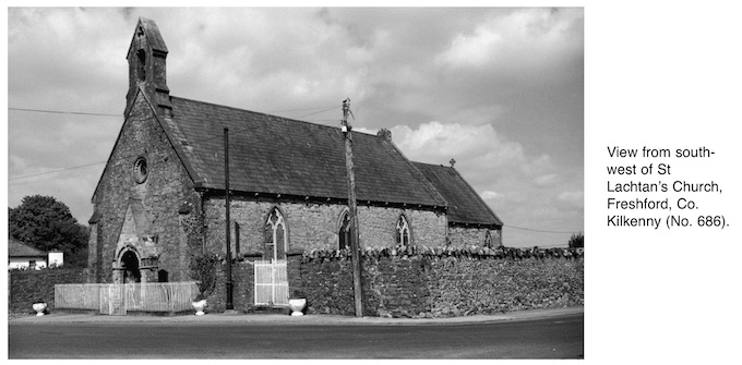
Site name: ST LACHTAN'S CHURCH, Freshford
Sites and Monuments Record No.: SMR 13:23
Licence number: 01E0815
Author: Ben Murtagh
Author/Organisation Address: Primrose Hill, Threecastles, Co. Kilkenny
Site type: Church and Graveyard
Period/Dating: Multi-period
ITM: E 640735m, N 664772m
Latitude, Longitude (decimal degrees): 52.732505, -7.396855
During 2001 an archaeological assessment was carried out to facilitate ongoing conservation work and renovations to this ancient parish church, 60m south of the River Nuenna, which is still in use by the Church of Ireland. It is located on the early medieval monastic site reputed to have been founded by St Lachtan in the 7th century. The church and adjoining graveyard are situated at the junction of Kilkenny Street and Newbridge Street in the centre of the modern village of Freshford, which now engulfs the early medieval monastic precinct.
The western half of the present building incorporates the pre-Norman stone church (Phase 1; c. 10th/11th centuries). This was an oblong building, constructed of roughly hewn blocks of local grey Carboniferous limestone masonry, bonded with a coarse lime mortar. There are original antae projecting from either end of the original north and south walls. The surviving three walls have been truncated by the insertion of later windows. In the west gable wall there are the remains of the fine mid-12th-century (Phase 2) Romanesque porch and doorway, constructed of dressed sandstone masonry.
During the 13th century (Phase 3) the east wall of the Phase 1 building was demolished and the church was extended eastwards. The surviving three original walls were incorporated into the nave of the extended building. The extended south wall has reused curved facing stones which may have come from a demolished round tower. The Phase 3 nave had a narrower chancel to the east, much of which still survives. The latter was renovated during the 14th/15th centuries (Phase 4).
The church appears to have been derelict for much of the post-medieval period (Phase 5). In the 1730s it was reroofed and renovated for worship by the Church of Ireland (Phase 6). During the 1820s an annex was constructed on the north side of the church (Phase 7). During the mid-19th century the latter was extensively renovated and reroofed (Phase 8). During the 20th century the building underwent minor alterations. In recent years the church has deteriorated, thus necessitating the current programme of conservation work and renovations. This is being funded by the Heritage Council and is being directed by architect Margaret Quinlin.
The assessment below the ground involved the excavation by hand of a series of test-cuttings and the opening of a number of inspection holes through the floors of the building. The purpose was to determine the impact of the laying of underground and under-floor services, as well as sub-floors. The investigation was divided up into a number of areas.
North of the church
To the north of the nave is the Memorial Garden. This was laid out in the 1820s over the earlier graveyard, which dates back to early medieval times. It involved the demolition of an earlier west boundary wall, which was flush with the west wall of the church. Around 1900 the garden became a graveyard. Three cuttings (A–C) were excavated along the inside of the north boundary wall.
Cutting A was excavated in the north-west corner of the garden. At a depth of 0.8mm, a metalled surface was exposed, which underlay the corner of the 1820s (Phase 7) boundary wall. It was located outside the demolished pre-1820s boundary wall. After the construction of the Phase 7 boundary walls, there was a rapid build-up of ground to the present level. This consisted of demolition rubble, fragments of roof slates, window glass and lead for glazing, probably from the church.
Cutting B was excavated about midway along the inside of the 1820s north boundary wall and to the east of the demolished pre-1820s west boundary wall. At 0.3m down, the surface of the pre-1820s graveyard was located. At a further 0.3m down into the grave soil an inhumation was encountered. The north side of the grave fill was truncated by the foundation of the 1820s boundary wall.
Cutting C was located at the north-east corner of the Memorial Garden at the west exterior of the 1820s (Phase 7) north annex. The surface of the pre-1820s graveyard was located at a depth of 0.5m. The foundation cut for the Phase 7 boundary wall and the annex truncated the pre-1820s grave soil and burials. The cut had been backfilled with a mixture of rubble and redeposited grave soil. Above this, the same material was used to raise the ground level.
Cutting D was located at the north end of the interior of the annex building. The latter was formerly divided in two: a schoolroom to the north and a vestry to the south. The cutting involved an inspection beneath the timber floor. At 0.35–0.45m below the latter was the surface of redeposited soil and other material which dated from the construction of the building. In the north-west corner a concrete-lined bunker had been inserted through this material.
Cutting E was excavated at the north end of the east exterior of the annex, at the north-west corner of a small walled garden or yard. It was revealed that during the 20th century there was a 0.64m build-up of ground, consisting of deposits of ash and rubble. This overlay another build-up of ground, which in turn overlay the surface of the pre-1820s grave soil and the fill of the foundation trench of the annex — mirroring what had been found on the other side of the latter in Cutting C.
Cutting F, 4m to the south of Cutting E, revealed the surviving lower courses of the demolished walls of a porch at the rear of the 1820s annex.
Chancel
Here the investigation involved the insertion of three inspection holes (Cuttings H1–3) through the timber floor of the interior. They revealed the surface of grave soil directly underneath.
Nave
During the mid-19th-century renovations (Phase 8) the ground level within the interior was reduced by about 0.6m for the purpose of under-floor heating. This involved the removal of a large amount of grave soil. A series of dwarf walls were built upon the surface of the lowered grave soil to support timber flooring. The latter on the south side had in recent years suffered from dry rot and it was proposed to replace it by backfilling the area between the dwarf walls to floor level with hard core. Beforehand, it was necessary to investigate the possible impact of the backfill on any inhumations in the underlying grave soil. Two test-cuttings (G1 and G2) were excavated into the latter. These revealed that there was a dense concentration of inhumations immediately below the surface of the lowered grave soil.
Cutting G1 was located 7m to the east of G2 and measured 1.5m by 1.5m. Here the remains of the foundation of the demolished east wall of the early medieval (Phase 1) church protruded up through the surface of the lowered grave soil. Underneath, it was found that the remains had been truncated by later burials. The wall was constructed of large, roughly fashioned fragments of grey Carboniferous limestone, with gravel used as packing between the stones. It was up to 1.17m in width and around 0.4m in depth. It directly overlay the natural, which was a glacially deposited mixture of boulder clay, sand and gravel. Around fourteen individual inhumations were identified, two of which were coffin burials. Two fragments of a medieval ridge tile were found, together with fragments of lime mortar and roof slates. This suggests that the date for the burials might centre on the period when the church was derelict during the 17th and early 18th centuries (Phase 5).
Cutting G2 measured 1.5m by 1m. It was 3.4m from the west wall and, like G1, 0.75m from the south wall. Also as in the case of G1, inhumations were found immediately below the surface of the lowered grave soil. Above the latter, in the north half of the cutting, was a layer of demolition rubble. In the north-west corner the natural was exposed immediately below the rubble. From here it dips in an easterly direction, below the grave soil. At the south end of the cutting there was a pit that cut into the natural. It was backfilled with a mixture of ash, redeposited soil and natural. The fill was truncated by at least two later burials. The upper fill had been removed by the lowering of the ground in the 19th century. Four individual inhumations were identified in the cutting. A well-preserved coffin burial was partially exposed and the lower part of the grave-cut truncated natural. As in the case of G1, the grave fill contained fragments of lime mortar and blue roof slates, thus supporting the view that they date from the period when the church was derelict (Phase 5).
West exterior of the church
Running lengthways along the exterior there is a narrow railed-off area fronting onto the footpath on what is now Newbridge Street. Up to the early 19th century this area was a cul-de-sac, which overlay the site of the west part of the early and later medieval graveyard right up to the church frontage. This resulted in a lowering of the ground level which truncated grave soil and burials. Today, within the railed-off area, there is a narrow grassed plot on either side of the mid-12th-century Romanesque porch. The latter projects out from the exterior of the Phase 1 church by 0.67m and is 3.15m in width. At either end of the Phase 1 exterior are projecting antae. Two cuttings (I and J) were excavated within the railed-off area, one each on either side of the porch.
Cutting I to the north revealed that the north anta overlay an offset plinth, which was concealed by modern topsoil. The latter also overlay a metalled surface below the bottom of the plinth which represented a later lowering of the ground level.
Cutting J at the south end of the porch exposed the remains of its plinth, which had been damaged by modern disturbance. The plinth of the west exterior of the Phase 1 Romanesque church was also exposed. It was intact, but the top was at a higher level than that of the adjoining porch. The conservation of the latter is to be addressed by the current phase of work.