County: Kildare Site name: COLLINSTOWN (Site 16/17)
Sites and Monuments Record No.: N/A Licence number: 01E0893
Author: Fiona Reilly, for Valerie J. Keeley Ltd.
Site type: Habitation site, Enclosure and Pit
Period/Dating: Medieval (AD 400-AD 1600)
ITM: E 697804m, N 736663m
Latitude, Longitude (decimal degrees): 53.371103, -6.530269
This site was found in Collinstown townland during the monitoring of topsoil-stripping of the Northern Link on the Celbridge Interchange (see Excavations 2001, No. 610). The scheme was approximately 4km in length and ran through gently undulating land from Celbridge to Leixlip, with a mixture of arable, pasture and woodland. The southern part of the scheme runs through an area heavily influenced by 18th-century landscape design, with avenues, woodland and tree-lined field boundaries centred on the early 18th-century house at Castletown. The site was initially identified as two sites but they were excavated under the same licence.
Site 16
The site can be divided into three phases. Phase 1, the earliest, consisted of all features which cut the natural subsoil. Phase 2 was the large northerly orientated ditch, and Phase 3 was the final phase of ploughing. Phases 1 and 2 may be contemporary but as explained below, have been dealt with separately.
Nine features were identified in Phase 1, mostly concentrated in the north-western area of the site. In the north-western sector there was a hearth feature, two shallow post-holes, two pits and a possible post-hole. In the south-eastern quadrant there was a linear cut and an oval pit. In the south-western corner was an oval cut. These features suggest a habitation site of some kind. There was, however, no obvious pattern to the post-holes nor enough of them to suggest a structure. The two post- or stake-holes close to the hearth may have been associated with it. Burnt and unburnt bone was found in the pit close to the hearth. It may have been a rubbish-pit. It was truncated on its southern side by a plough-furrow.
Two pits, 0.35m apart, were found in the southern area of the site. Burnt and unburnt bone was found in the fills of one of them. Burnt bone and a sherd of medieval pottery were found in pit C23. The sherd was the only artefact from this phase and therefore suggests a medieval terminus post quem for it.
Phase 2 is represented by a large northerly orientated ditch which cut through the entire site. It did not truncate any of the features described in Phase 1 so may be contemporary with them. It had a C-shaped profile in the south and a rounded V-shaped profile in the north. The fills varied from north to south. The fills of the ditch produced animal bone, cremated bone and two fragments of human skull. The skull fragments were found at the base of the ditch, along with 23 cattle-sized vertebrae fragments. Other cattle parts included a molar, a horn core, a humerus, a metacarpal and a metatarsal. These disarticulated bones were probably dumped into the ditch when it was open. The only artefact found in the ditch fills was an iron blade. Five fragments of cremated animal bone were found in the same fill as the blade.
This feature seems to have been a boundary ditch. It does not correspond to any ditches marked on the first edition OS map so must pre-date the early 19th century.
Phase 3 is represented by nine plough-furrows. They ran across the site from east to west and truncated the large ditch and some other features. They varied in width from 0.8m to 0.3m. Several post-medieval artefacts were found in the furrow fills, including pottery sherds, glass, clay pipe fragments and a nail. A flint flake was found in fill C12. Other artefacts were found in the topsoil during cleaning. These included a silver button, nails and two flint flakes.
Site 17
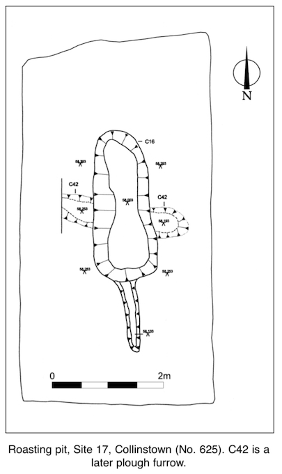
This lay 15.4m to the south-east of Site 16. The area measured 6m by 4m and was visible as two charcoal-rich deposits. The site can be divided into two phases.
Phase 1 is represented by a northerly orientated bottle-shaped cut. It was 4m in total length and 1.08m wide in the oval part. The 1.3m southern projection was 0.25m wide. It was dug into the natural subsoil. It had vertical sides in the flue and gradual concave sides in the main oval section. The base was flat. The main, widest, part of the cut had eight fills. Some of these fills partly filled the flue; two were confined to the flue only. The fills were rich in charcoal and ash, and some contained burnt clay and bone.
At first it was thought that this feature might have been a corn-drying kiln. A portion of one of the charcoal-rich fills was sieved in an attempt to identify some charred seed remains. None were found. All the identified fragments of bone found in the fills were of juvenile pig and had been burned at 300–600ºC. Because of the ash deposits and cremated bone fragments it can be suggested that this feature was a pig-roasting pit. It is not possible to determine whether it is contemporary with the features on Site 16.
Phase 2 is represented by an east–west-running furrow, probably contemporary with the furrows on Site 16 to the north.
Final post-excavation work has not yet been carried out.

Wood Road, Cratloekeel, Cratloe, Co. Clare