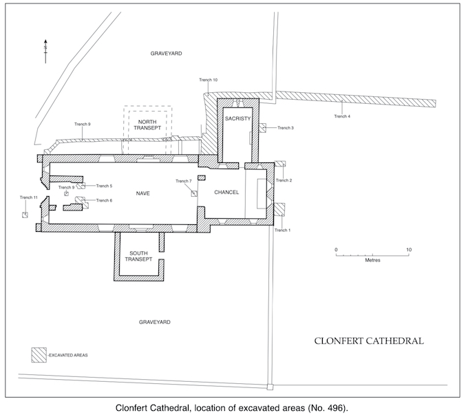
2001:496 - CLONFERT CATHEDRAL, Clonfert, Galway
County: Galway
Site name: CLONFERT CATHEDRAL, Clonfert
Sites and Monuments Record No.: N/A
Licence number: 01E0877
Author: Claire Walsh and Alan Hayden, Archaeological Projects Ltd.
Author/Organisation Address: 25a Eaton Square, Terenure, Dublin 6W
Site type: Cathedral and Graveyard
Period/Dating: Early Medieval (AD 400-AD 1099)
ITM: E 595869m, N 719500m
Latitude, Longitude (decimal degrees): 53.225884, -8.061854
The Heritage Council commissioned a conservation plan for Clonfert Cathedral, Co. Galway. This identified several structural problems and faults in the cathedral. Initial test excavation, followed by excavation and monitoring of the first phase of remedial works, was undertaken on the site between 18 October and 14 November 2001.
Clonfert was founded in the 6th century by St Brendan, and the fine cathedral was probably constructed in the later 12th century.
AREA 1 — Field east of church and graveyard
Three small test-trenches (nos 1–3) were opened adjacent to the external face of the east walls of the church and sacristy to examine their foundations. A 22m-long, 1m-wide trench, aligned east–west, was opened across the field to hold the end of the new drain taking water from the roof of the north side of the church (see Area 3 below).
Burials, where encountered, were avoided rather than excavated.
Features were uncovered which provide evidence for the presence of early medieval buildings and activity in the field east of the church. A ditch revealed at the east end of Trench 4 is also likely to be of early medieval date. It is probably part of the original enclosure around the monastery. The enclosing earthworks can be seen in the field on the opposite side of the roadway south of the church, curving towards the area where the trench was opened.
The east walls of the chancel and sacristy of the church both had projecting footings at their base which stand proud of the modern ground level to their east. This suggests that the ground level east of the church has been reduced in modern times. Burials were encountered only 75mm below modern ground level in Trenches 1 and 2. Sir Oswald Mosley, who lived in the nearby Bishop’s Palace in the 1950s, reportedly bulldozed the area, removing trees and scrub. He also evidently removed a thickness of at least 0.6m of deposits, leaving only the very base of the graveyard soil.
The northern limit of the graveyard in the field east of the church may lie on a line with the north end of the sacristy, south of Trench 4.
Interior of nave
Four small trenches were opened in the nave to examine the footings of the piers supporting the tower at the west end of the nave, and the floor of the nave. The excavated trenches gave a consistent picture of the deposits in the nave. Subsoil lies at 0.55m below modern floor level. A thick layer of loam, whose upper level lies 0.2m below floor level, overlay subsoil. This material is soil disturbed by burials in the church and contained much disarticulated human bone. The absence of any post-medieval material in the loam suggests that it is of medieval date. Intact human burials were uncovered in all but Trench 7 (which was not excavated below the level of the Victorian heating flue). The burials lie at a minimum depth of 0.39m below floor level. The interior of the church was evidently used for burial over a long time. A burial appeared to underlie the pier supporting the north side of the tower in Trench 5, while the burials in Trench 6 probably post-dated the pier supporting the other side of the tower. The tower is 15th-century in date.
The south-east corner of the footing of the pier supporting the north side of the tower appears to have slumped down into an earlier grave. This, coupled with the undermining caused by the insertion of the Victorian heating flue, may be at least partly responsible for the subsiding of the tower. The footings of the tower are clay-bonded. The 15th-century floor lay less than 0.1m below modern floor level. This suggests that the modern reflooring of the nave with concrete may have disturbed most of the late medieval floor.
AREA 3 — Sacristy, north transept and graveyard north of the church
Drains are to be built to take the water from the roof of the north side of the church. At present the downpipes feed into short lengths of pipe which run out into the graveyard. These are to be replaced by a single drain leading water to the field east of the church.
The excavation revealed the original width of the west wall of the sacristy. No burials were encountered in the area. The continued use of the graveyard here into modern times appears to have removed a greater depth of older burials than in the church.
Silty clay containing human bones underlay the modern deposits in the area. The footings of the east and west walls of the north transept were uncovered. The western wall lines up well with the intermittent scar visible on the nave wall. There is no clear scar of the east wall visible on the nave today. The north transept would appear to have been the same width as the southern one but the two were not symmetrically placed on either side of the nave. A burial vault was uncovered under the chancel and sacristy which pre-dates the Victorian re-edification of the sacristy. Its exact date is, however, unknown.
AREA 4 — North transept
The east and west walls of the north transept are collapsing. They are to be taken down and rebuilt. When the walls have been removed a test-trench will be dug to examine their foundations. The visible stonework in the east and west walls (internal and external faces) and the east and west corners of the south gable was drawn at a scale of 1:20, numbered with white emulsion, and photographed. Stones, including dressed coping stones, have fallen from the south-east corner of the transept. These were also planned, lettered with white emulsion and photographed.
Sump, boreholes and driven probes in various locations
A small sump (Trench 11) measuring 0.8m by 1m across was excavated outside the south-west corner of the west end of the church to drain the southern half of the area outside the west doorway. Graveyard soil was uncovered. A borehole was opened at the edge of the road outside the entrance to the graveyard. Subsoil was reached at 0.65m below modern ground level. A layer of dark brown silty clay overlay subsoil. This underlay a layer of cobbles, which immediately underlay the modern tarmac road surface. Several probes gave readings on the resistance strength of subsoil.