2001:345 - COLDWINTERS (Site 5), Dublin
County: Dublin
Site name: COLDWINTERS (Site 5)
Sites and Monuments Record No.: N/A
Licence number: 01E1062
Author: Kieran Campbell, for Valerie J. Keeley Ltd.
Author/Organisation Address: 6 St Ultan’s, Laytown, Drogheda
Site type: Fulacht fia and Pit
Period/Dating: Prehistoric (12700 BC-AD 400)
ITM: E 719368m, N 751908m
Latitude, Longitude (decimal degrees): 53.503608, -6.200613
Site 5 on the Northern Motorway (Airport to Balbriggan Bypass) was uncovered on 15–16 August 2001 by Patricia Lynch during monitoring of topsoil-stripping under licence no. 00E0953 (no report received). In Coldwinters townland, 2km inland from the head of the Rogerstown estuary, two low ridges cross the road-take from west to east. Site 5 consisted of two areas 120m apart, located at the western margin of the road-take. Area 1, a fulacht fiadh, lay in the hollow between the two ridges. Area 2, a prehistoric pit, was on the summit of the northern ridge. The site was immediately north of Site 4, an enclosure and cemetery, located on the southern ridge and excavated by Hilary Opie (Excavations 2001, No. 344). The excavation took place from 22 October to 26 November 2001.
Area 1
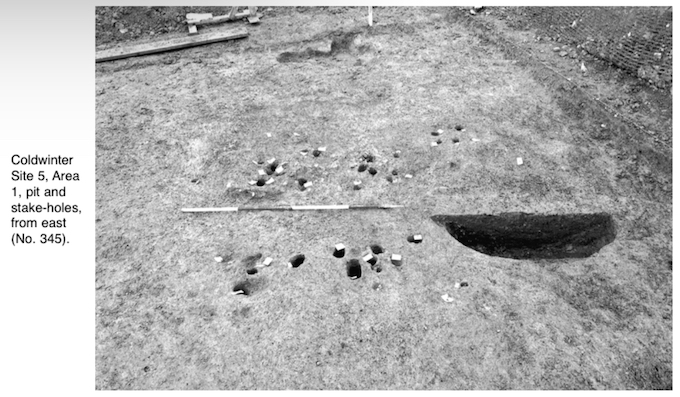
At the time of discovery a 10m by 8m area was fenced off around a light scatter of burnt stones. A foundation layer for the motorway embankment was later laid down around the fenced-off area and determined the limit of excavation. The burnt stones occurred as occasional inclusions, with charcoal, in a stony grey silty clay, average thickness 0.04–0.08m, which covered most of the cutting. Removal of the grey silty clay exposed 43 stake-holes and a large pit cut into the natural subsoil. The pit was oval in plan, 1.96m by 1.4m and 0.57m deep, with steep straight sides and a flat base. Burnt mound material formed a large component of the lower fills, particularly against the south side. The upper fills were more silty in texture with only occasional burnt stones and charcoal. The pit filled with water within c. 24 hours of excavation and could well have functioned as the trough of a fulacht fiadh.
Forty-three stake-holes were recorded in the cutting, mainly in the vicinity of the pit. On the south side of the pit two parallel linear arrangements of stake-holes were aligned north–south and set c. 1m apart. The arrangement of stake-holes suggested a fence line or lines, or a light structure, related to the use of the pit. Some of the stake-holes occurred in closely set groups of four. It was not possible to determine whether all the stake-holes were contemporary or resulted from successive phases of building.
A further group of fourteen stake-holes, forming no discernible pattern, lay within a 2m by 2m area at the south edge of the cutting. It is likely that this group continues south beyond the limit of the excavation.
Area 2
A large, shallow, subrectangular cut, 3.88m long, 2.24m wide and 0.48m deep, was recorded in isolation on a 5m-wide strip of ground at the western margin of the road-take. Owing to previous motorway earthworks there was no opportunity to expand the 5m by 10m area of investigation. The basal deposit, which filled much of the northern end of the pit, was a light brown silty clay with occasional charcoal flecks and was difficult to distinguish from natural subsoil. Dark charcoal-enriched deposits in the southern end of the pit contained burnt stone, burnt bone, flint and pottery. The large quantity of flint, c. 320 pieces, was mostly débitage, but included convex scrapers and a flint nodule worked to a spherical shape, 43–47mm in diameter. The pottery, 75 sherds, was in a coarse fabric with large granitic inclusions. One body sherd has possible incised line decoration. Given the abundance of artefacts in the pit, indicative of habitation, it is likely that the pit is part of a larger site. No additional archaeological features were uncovered in the limited area available for investigation, but the ridge on which the pit was located continues west beyond the road-take as undisturbed farmland.