2001:223 - MONEYREAGUE, Cork
County: Cork
Site name: MONEYREAGUE
Sites and Monuments Record No.: RMP 93:33
Licence number: 01E0694
Author: Margaret McCarthy, Archaeological Services Unit, University College Cork
Author/Organisation Address: —
Site type: Standing stone and Cremated remains
Period/Dating: Prehistoric (12700 BC-AD 400)
ITM: E 519032m, N 558890m
Latitude, Longitude (decimal degrees): 51.776449, -9.173341
Excavations were undertaken at Moneyreague, Dunmanway, Co. Cork, prior to the reinstatement of a displaced standing stone. The work was carried out over a two-week period from 20 to 31 August 2001. A trench (4m x 4m) was set out around the base of the standing stone. The excavation commenced with the removal of the topsoil, a loose mid- to dark brown humic sandy silt. This overlay an orange stony boulder clay or the natural subsoil. Three pits and a spread of redeposited clay were apparent on the surface of the subsoil. The backfilled socket was also visible and this was excavated after the removal of the standing stone. A narrow trench measuring 4.2m in length was opened to the north-west of the main cutting to investigate the possibility of a ditch surrounding the monument.
A spread of redeposited orange boulder clay representing upcast from the excavation of the socket was visible to the north and south of the standing stone. It measured 2.1m by 0.82m on the north side and was apparent as a subcircular spread of clay on the south side. Three features were cut into this, a substantial pit with cremated bones at the base of the stone to the west and two smaller pits to the north.
The upper level of the large pit was visible as a brown humic deposit to the west of and adjacent to the socket of the stone. The pit was subcircular in plan and measured 0.99m by 0.73m. The north-west edge of the pit cut through the upcast from the stone socket and the south-east edge cut through the backfilled socket. A small stake-hole was excavated at the north-west edge of the pit. This was circular in plan, with steep straight sides and a rounded base. It measured 0.1m in diameter and 0.14m in depth. The fill consisted of a black sandy silt with occasional charcoal. It was no different to the layer that sealed the base of the pit and it appears that the stake was driven in and removed immediately before the first episode of infilling.
The stake-hole and the base of the pit were sealed with a primary deposit of black, charcoal-enriched sandy silt containing numerous fire-reddened medium-sized stones and large quantities of charcoal. This layer was c. 0.17m thick. A quantity of cremated human bone was recovered from the southern side of the pit. A setting of four irregularly shaped large stones sealed the bone. None of these stones were heat-reddened and they were clearly placed on the cremation deposit after it was inserted into the pit. The stone arrangement was sealed by an upper fill consisting of a mid- to dark brown sandy silt containing numerous pebbles and occasional medium and small stones and charcoal. The contents of the pit were processed in the Department of Archaeology, UCC, for the extraction of organic remains and material finds. The sorted residues yielded additional fragments of cremated human bone and small pieces of charcoal. At least three fragments of bone were identified as human remains and these have been submitted to the radiocarbon laboratory in Groningen for radiocarbon analysis.
In addition to the large burial pit, two smaller pits were exposed to the north of the standing stone. F3 was a small pit that cut through the redeposited boulder clay. It was subcircular in plan, 0.15m in diameter and 70mm deep. The fill was a brown sandy silt containing tiny charcoal flecks and occasional pebbles. The other pit, F5, was located 0.12m to the south of F3. It was roughly oval in plan (0.25m x 0.31m) and reached a maximum depth of 0.16m. The north and east sides sloped gradually to an uneven base, 0.11m in width. The pit cut into the layer of redeposited boulder clay and the north side of the backfilled socket for the standing stone. The fill consisted of a loose dark brown to black silty sediment containing occasional small pebbles and charcoal.
The standing stone had to be removed in order to complete the excavation. Large industrial belts were wrapped around the stone and it was then gradually lifted out of its socket using a mechanical excavator, and placed on the ground close to the excavation trench. The full extent of the damage caused by the landowner became apparent once the standing stone was removed. The area to the immediate east of the stone was clearly disturbed, and the surface was uneven and strewn with large stones and boulders. Some of these stones may have been used for packing, but the damage was so extensive that it was difficult to establish where the stones originated.
The socket for the standing stone was a linear trench with rounded ends, measuring 2m in length and c. 0.55m in width. It was slightly wider (0.58m) in the central area and narrowed towards the ends, particularly at the north-east end. It was U-shaped in section and the central depth was 0.4m. The sides were straight and steep and the base was somewhat uneven. The socket was virtually the same width at the base (0.53m) as at the top.
A post-hole was located at the base of the socket at the extreme north-eastern end. This was circular in plan, had straight sides and sloped sharply to a rounded base. It measured 0.41m in diameter and reached a maximum depth of 0.42m. The fill was similar to that of the socket, indicating that it was dug and backfilled at the same time as the standing stone was placed upright into the socket. No definite explanation can be offered for the existence of this feature but it does represent a deliberate cut at the base of the socket. During the reinstatement of the standing stone, a large post was placed into the base and side of the socket to keep the standing stone in its correct orientation while it was being backfilled. It is possible that this post-hole represents a construction feature such as a wooden support used during the erection of the stone.
The fill of the socket was homogeneous throughout and consisted of a very stony light to mid-brown sediment containing frequent charcoal inclusions but no cremated bone. There was charcoal throughout but it was concentrated particularly near the edge of the cremation pit, and it has to be considered that this is intrusive and not part of the original fill. The contents were bulk-sampled but no finds or organic material were present in the fill.
The excavation yielded burial evidence in the form of a pit containing cremated human bone. The burial pit post-dated the construction phase as it cut through the southern side of the socket for the standing stone. Regrettably, there is no independent dating evidence for the primary construction phase. Neither can a direct link be established between the two smaller pits to the north-east of the burial pit. They were stratigraphically coeval with the larger pit as all three cut into the layer of redeposited boulder clay upcast from the socket. No soil layer had accumulated over the redeposited boulder clay before the digging of the pits, so it is likely that little time had elapsed between the erection of the standing stone and the subsequent pit activity.
The limited number of fills within the cremation pit suggests a single episode of deposition of cremated human bone. The remains were carefully placed in the base of the pit and sealed with four large stones before the entire pit was backfilled with charcoal and burnt stones. This material presumably originated from the cremation pyre. The small amount of bone suggests a token deposit. The sides and base of the pit were slightly oxidised, indicating that it was purified prior to the insertion of the cremated remains. The exact function of the smaller pits is unknown and there is no independent dating evidence for either of these two features.
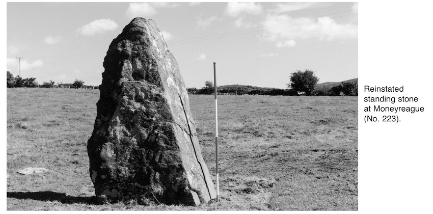
The final site conservation involved re-erecting the standing stone, and this work was undertaken by personnel from Dúchas. The main objective was to restore the displaced standing stone to its former position and to align it on its correct orientation. The stone was placed back into the socket by a mechanical excavator and was then propped with wooden stakes while the socket was backfilled. Most of the stones removed by the landowner from the north-east side of the socket were replaced as packing material. When standing, the stone was aligned south-west/north-east. The above-ground height is 2.6m and the stone measures 1.4m in width and 0.5m in thickness.