2001:030 - CHAPELTOWN, Carlow
County: Carlow
Site name: CHAPELTOWN
Sites and Monuments Record No.: RMP 7:65
Licence number: 00E0829 ext.
Author: Edmond O’Donovan and John Ó Néill, Margaret Gowen & Co. Ltd.
Author/Organisation Address: 2 Killiney View, Albert Road Lower, Glenageary, Co. Dublin
Site type: Enclosure
Period/Dating: Undetermined
ITM: E 674409m, N 675996m
Latitude, Longitude (decimal degrees): 52.829777, -6.895799
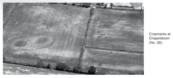
The site was first identified during an archaeological aerial survey conducted by Dr Gillian Barrett, University of Wolverhampton (Barrett 1995). This work led to the scheduling of the site in the Record of Monuments and Places. Proposed development at the site led to test excavations in 2000 (Excavations 2000, No. 31). Further consultation with Dúchas and the acquisition of a copy of the original aerial photograph (courtesy of Dr Barrett) prompted another phase of testing of the site in 2001.
The site is on low-lying ground alongside the Burren River, south-east of Carlow town. The cropmark is visible as an elliptical enclosure measuring some 70m (east–west) by 50m, on the northern side of the river. Two large circular features, each some 20m in diameter, are present within the enclosure, with a clear entrance on the south, and a possible second, directly opposite it, to the north. The site has few clear parallels in the known corpus of field monuments in Ireland. The monument is symmetrical across its north–south and east–west axes. A 35m-diameter circular enclosure and a 15m-diameter enclosure are present in the field to the east (SMR 7:66 and 7:67). Other less distinct features can also be identified in the vicinity of all three enclosures.
Five further trenches were opened across the site in 2001. In all cases, only the topsoil was removed during the assessment. Three trenches were opened across the enclosing feature, which was confirmed as a ditch. It was exposed in all three trenches and was found to be 1.9–2.1m in width. In one trench burnt bone and charcoal were clearly visible within the exposed upper fills of the ditch. The 20m-diameter circular feature in the eastern side of the enclosure was partially exposed. This was a substantial deposit of mixed gravels, rounded and weathered stone. The origin of this feature was obscure (it may have been natural or artificial), but the presence of it and its twin within the enclosure, along with burnt bone in the ditch, suggests a prehistoric site of some religious or ceremonial significance. This is also borne out by the presence of the other monuments in the field to the east.
Reference
Barrett, G.F. 1995 Recovering the hidden archaeology of Ireland: the impact of aerial survey in the River Barrow valley, 1989–91. In O. Braasch and G. Wetzel (eds), Aerial archaeology in eastern and central Europe, 45–59. Proceedings of the Kleinmachnow Conference, Brandenburg Museum, Potsdam.