County: Waterford Site name: DUNGARVAN CASTLE, Dungarvan
Sites and Monuments Record No.: N/A Licence number: 95E0080
Author: Dave Pollock,
Site type: Castle - Anglo-Norman masonry castle
Period/Dating: Multi-period
ITM: E 626013m, N 593597m
Latitude, Longitude (decimal degrees): 52.093676, -7.620363
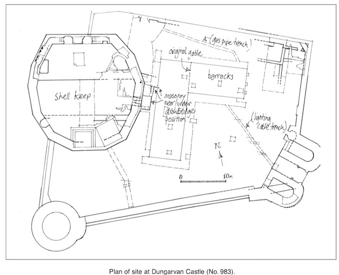
Groundworks were monitored during refurbishment and consolidation of the mid-18th-century (and c. 1700) barracks at Dungarvan Castle.
Within the barracks, stripping plaster from the west gable of the original building exposed the remains of single blocked windows on both storeys. Lowering the ground floor to insert damp-proofing generally failed to reach medieval levels.
Outside the barracks a number of service trenches were monitored. At the foot of the shell keep, more masonry was found close to the drawbridge position (masonry was found during testing in 1999, Excavations 1999, 293–4), and indications were found for a late medieval or post-medieval recutting of the ditch, which had damaged the medieval masonry.
To the north of the barracks, the cutting of a gas-pipe trench grazed the upcast clay associated with the late medieval ramparts, sealed below a deep, imported cultivation soil, which appeared to pre-date the barracks.
To the east of the barracks the shallow cut for a lighting cable ran over and occasionally cut into late medieval or early post-medieval surfacing in the yard. Indications of burning on the old ground close to and in the passage of the gatehouse appear to be related to burning in the north-east corner of the yard and elsewhere seem to be associated with 16th- or 17th-century warfare.
A distinct alignment could be seen in the various pieces of surfacing in the yard, suggesting an indirect medieval route from the gatehouse to the drawbridge on the keep. Traffic appeared to have travelled parallel to the south curtain, potentially between a lean-to against the wall and a parallel, free-standing structure.

Knockrower Road, Stradbally, Co. Waterford