2000:0810 - CLONMACNOISE, Offaly
County: Offaly
Site name: CLONMACNOISE
Sites and Monuments Record No.: N/A
Licence number: 99E0715
Author: Donald Murphy, Archaeological Consultancy Services Ltd.
Author/Organisation Address: 15 Trinity Street, Drogheda, Co. Louth
Site type: Enclosure, Burial and Habitation site
Period/Dating: Medieval (AD 400-AD 1600)
ITM: E 600913m, N 730669m
Latitude, Longitude (decimal degrees): 53.326277, -7.986294
An area measuring 16.65m east–west by 29.25m was excavated to the south of the existing tourist office building just north of the base of the slope of the esker ridge (Eiscir Riada). Significant archaeological features were exposed on the site, representing three distinct phases of activity. The most recent phase is characterised by the presence of cultivation furrows that run north–south through the cutting. The furrows were all roughly U-shaped, were generally evenly spaced and maintained a fairly consistent depth and width. Their alignment and consistency would indicate that they were all roughly contemporary. Near the north end, three of the furrows had associated post-holes and all three furrows were quite shallow, c. 0.05m.
Nine pits were exposed cut into the natural, grey and brown sand below the cultivation furrows. These are probably roughly contemporary and, though no definitive dating evidence was recovered, are likely to post-date the infilling of the ditch (see below). Other, smaller features were exposed, including a possible stone setting, a spread of charcoal and iron slag, a linear slot-trench, a possible bowl-shaped furnace and an ash and charcoal spread.
Two burials were also uncovered along the south baulk below the topsoil and cut into the natural sand. Both burials were extended female inhumations aligned east–west in simple grave-cuts. Burial 1 was that of an adult female aged between 25 and 30 years. This individual had a severe stress fracture of a vertebra and fractures to the first ribs and sternum. These may all have been caused by exerting extreme force such as was required for lifting or moving a heavy object. Although the fractures did not result in immediate death, they may have led to complications causing death a short time later. A sample of bone from the burial produced a radiocarbon age of 748±42 years BP, which gave a calibrated date range of AD 1252–78.
Burial 2 was that of a female aged 35–50 years. This individual had suffered three broken ribs, possibly as a result of a blow or a falling object, and was already exhibiting signs of degenerative joint disease that would have become worse with increasing age. A sample of bone from the burial produced a radiocarbon age of 816±43 years BP, which gave a calibrated date range of AD 1182–1262. Both burials had some similar congenital abnormalities that may hint at a possible genetic link between the two. It is also possible that they lie on the northern fringes of a much larger cemetery.
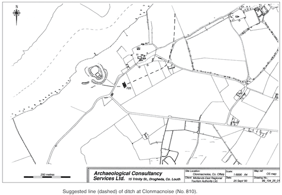
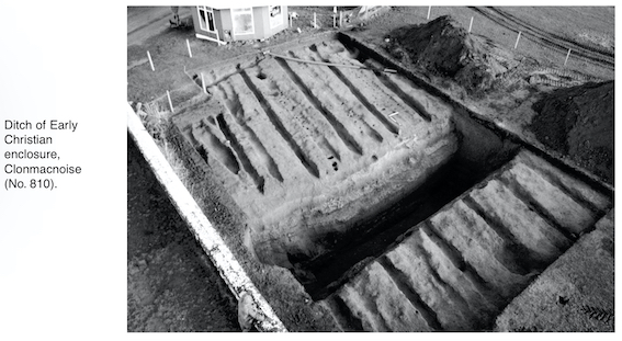
The burials occurred to the south of a large infilled ditch, 6.2m wide at the top and 1m wide at the bottom at the west end, and 5m wide at the top and 1.7m wide at the bottom at the east end. It was 3.7m deep at the west end and 3.8m deep at the east end. The ditch was roughly V-shaped in profile but with a flat bottom. The northern side was stepped, as was a portion of the south side in the south-west corner. There was clear evidence for slippage near the west end, where sands had slipped down into the bottom of the ditch along the northern side, indicating that perhaps there had been a bank along the north side originally. It would appear from the main fill, a sandy, grey-brown soil, that the ditch was filled in one episode rather than silting up over a long period of time. Animal bone recovered from the main fill provided a date of 1228±43 years BP, which gave a calibrated date range of AD 714–873. This would suggest that the ditch was purposely infilled during the 8th/9th century. The ditch represents an outer enclosing element of the early monastic complex.