2000:0787 - TULLYKANE, Meath
County: Meath
Site name: TULLYKANE
Sites and Monuments Record No.: N/A
Licence number: 00E0264
Author: Christine Baker, Arch-Tech Ltd.
Author/Organisation Address: 32 Fitzwilliam Place, Dublin 2
Site type: Habitation site
Period/Dating: Late Medieval (AD 1100-AD 1599)
ITM: E 690011m, N 757175m
Latitude, Longitude (decimal degrees): 53.556768, -6.641470
A two-week monitoring programme took place at Tullykane, Kilmessan, Co. Meath, encompassing an area c. 500m east–west by 70–100m. Archaeological features were identified including hearths, ditches, possible house structures and a substantial number of medieval pottery sherds. A preliminary interpretation of medieval rural settlement was reached, and after consultation with the National Monuments Service a full archaeological excavation took place.
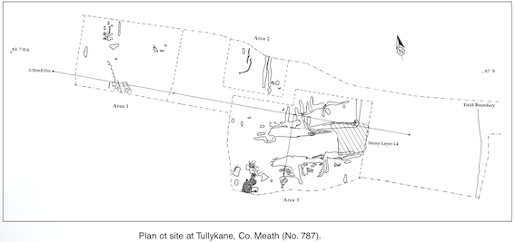
The zone of archaeological deposits encompassed an area measuring 125m east–west by 30–55m, c. 150m west of the boundary of soil-stripping, while the northern and southern limits were defined by the extent of soil-stripping and the quarry face respectively. The site was severely truncated by heavy agricultural activity. All archaeological deposits were revealed well down at the base of the topsoil and either directly overlay or were cut into the natural subsoil. The archaeological features were not continuous but could be divided into three distinct concentrations, Areas 1, 2 and 3.
The highest density of activity was concentrated within Area 3, which had maximum dimensions of 55m east–west x 40m. As evidenced elsewhere on the site, this section was partially characterised by singular features having little direct relationship with one another except that they shared the same horizon of activity. This horizon was extremely shallow, averaging 0.2m but varying from 0.05m to 0.5m in thickness. It was primarily defined by the presence of medieval pottery and features such as ditches, gullies, pits, hearths and burnt spreads. The eastern quadrant of Area 3 had two distinct foci of activity (north and south) delineated by shallow ditches that ran west-south-west/east-north-east. There was one deposit that linked the two foci, a deliberately laid layer of stone and gravel. It extended for 14m east–west x 12m and partially overlay ditches F28 to the north and F6 to the south. Structure 1 (south) was a rectilinear space 5m north–south x 9.5m, enclosed by two foundation trenches with rounded terminals to the east and west and delimited by a ditch to the north. Contained within Structure 1 were several depressions with charcoal-rich deposits, small pits and a series of 26 stake- and post-holes encompassing an area 3.5m east–west x 2m. Immediately west of Structure 1 was an extensive area of mixed dump material with charcoal and bone inclusions.
Area 2 measured 25m east–west x 20m (max.) and encompassed a total of ten features. These included two parallel ditches, which ran north–south for approximately 13m before terminating. They had similar fills and were both sealed by L31, indicating a contemporaneous date of usage. To the south-east was a concentration of activity including depressions and pits with associated burnt material. To the west was a curious curvilinear gully, which seemed to extend to a similar, slightly bifurcated north–south feature (F130). Both had similar dimensions and fills. They did not enclose a definable area, but a shallow, oval deposit of burnt material was present 1.5m to the west of F130.
Located c. 20m west of Area 2, Area 1 measured c. 30m north–south x 40m. It contained fifteen dispersed features including a probable structure. Structure 2 consisted of linear slot-trenches, several areas of intense in situ burning and three pits within an area that measured 8m north–south x 4.2m. To the east was a north–south gully, which possibly relates to the structural activity.
Although its function is not immediately apparent, it can be suggested that the site had a specific purpose in that it was occupied for a relatively short period of time. It has been truncated by heavy agricultural activity, although the absence of post-medieval/modern inclusions is significant. Of the 4028 sherds recovered, 99.68% were identified as medieval pottery. Almost all were Irish wares, reflecting domestic settlement, and datable to the later 13th century (C. Sandes, pers. comm.)