2000:0731 - DOOYORK, Mayo
County: Mayo
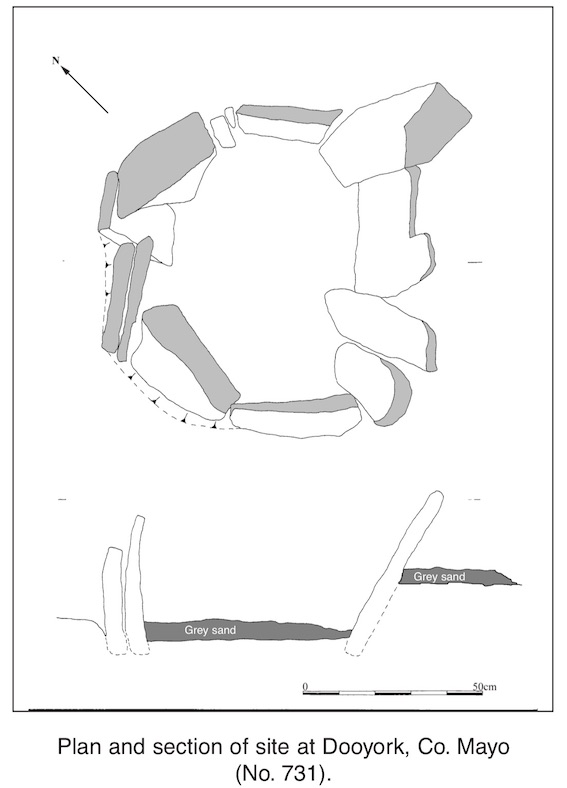
Site name: DOOYORK
Sites and Monuments Record No.: N/A
Licence number: 00E0802
Author: Christiaan Corlett, Dúchas, The Heritage Service
Author/Organisation Address: 6 Ely Place Upper, Dublin 2
Site type: Cist
Period/Dating: Undetermined
ITM: E 473428m, N 820109m
Latitude, Longitude (decimal degrees): 54.114446, -9.935930
This coastal site (previously unrecorded) was reported to Dúchas The Heritage Service in October 2000 by local people concerned that it would be destroyed by storms; the site had recently been exposed following storms that had eroded the sand dunes. A visit to the site by Mary Cahill of the National Museum of Ireland confirmed that the site was a cist-like stone structure under threat from coastal erosion. It was decided to undertake a rescue excavation of the site as a means of preservation by record in advance of its imminent destruction.
The site was located on the seashore at Dooyork, near Gweesalia. The coastline here consists of extensive sand dunes overlying an ancient bog, which can be seen extending into the foreshore to a level just above the low tide mark. On arrival to the site a stone cist-like structure was visible practically sitting on the surface of the ancient bog. It was immediately clear that the structure had previously been covered by the sand dunes and recently exposed. This was confirmed by local informants.
The cist-like structure consisted of ten stones set upright and on edge, enclosing an oblong area 0.5m x 0.72m. The upright stones were 0.5–0.7m high, 103–145mm wide and 25–105mm thick. The slabs set on edge were 0.25–0.5m high, 0.25–0.45m wide and 20–75mm thick. One of these slabs on the western side had a vertical split through the stone.
There was no evidence for covering stones in situ or displaced. Indeed, the uneven heights of the stones forming the cist would have made this structure difficult to cover with one or even more stones.
Before excavation the interior contained much sand and beach cobbles, evidently carried in by the rising and falling tides. Once this material was removed it was found to cover a distinctive grey sand. This sand was also found outside the cist along the south-eastern side. It was clear that this sand had accumulated naturally in the cist and along the sheltered side of the structure. A copper link and a coin dated 1803 were found in this grey sand within the cist.
Beneath this grey sand was the ancient bog surface. It was clear that the cist had originally been inserted into this bog surface and that the grey sand was a subsequent build-up. There was no evidence for a fill in the cist that pre-dated this grey sand. There was also no evidence for burning of the underlying peat that would indicate that this was used as a hearth.
The function and date of the cist are unclear. It may be an unexplained structure dating to the late 18th or early 19th century, representing some contemporary form of use of the foreshore. Alternatively it may be a prehistoric burial cist inserted into the bog and subsequently eroded by sea action, removing covering stones, internal deposits and external supporting material such as sand or bog around the cairn. This may explain the fact that the stones of the cist seem to have fallen slightly outwards. If such were the case, then the coin of 1803 would indicate a date for this event and the deposition of the grey sand. It appears then that the site was covered by the sand dunes shortly after and was only re-exposed by the recent storms.