County: Louth Site name: NEWTOWN–MONASTERBOICE (Site 1)
Sites and Monuments Record No.: N/A Licence number: 00E0796
Author: Cóilín Ó Drisceoil, for Valerie J. Keeley Ltd.
Site type: Fulacht fia
Period/Dating: Prehistoric (12700 BC-AD 400)
ITM: E 704543m, N 780476m
Latitude, Longitude (decimal degrees): 53.763389, -6.414388
The site was found by Kieran Campbell during the monitoring of topsoil-stripping for the Northern-Motorway (Drogheda Bypass). It lay beside a stream on a gentle south-facing slope above an area of fen-peat.
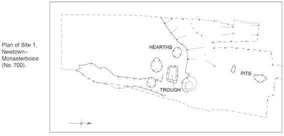
An area 26m x 10m was identified for excavation. In the centre of this was an irregularly shaped deposit of burnt mound material, 15m x 8m x 0.4m max. depth. Much of this material was contained within a scarped hollow. The bulk of the deposit was of charcoal, ash and disaggregated sandstone. When this was removed, four circular pits surrounding a rectangular trough were found. Only one of these contained definite evidence for in situ burning. Given the similarity with the form and arrangement of the other three pits around the trough, it seems likely that they also functioned as hearths. A convex scraper was found in the fill of one of these. Four metres to the north were two further irregularly shaped pits containing burnt stones and ash.
The trough was 2m x 1.4m x 0.55m max. depth. It was filled with burnt mound material. Although no wood survived, the impressions of at least three planks could be seen running lengthways in the basal subsoil. Radiocarbon dates are awaited.

6 Riverview, Ardnore, Kilkenny