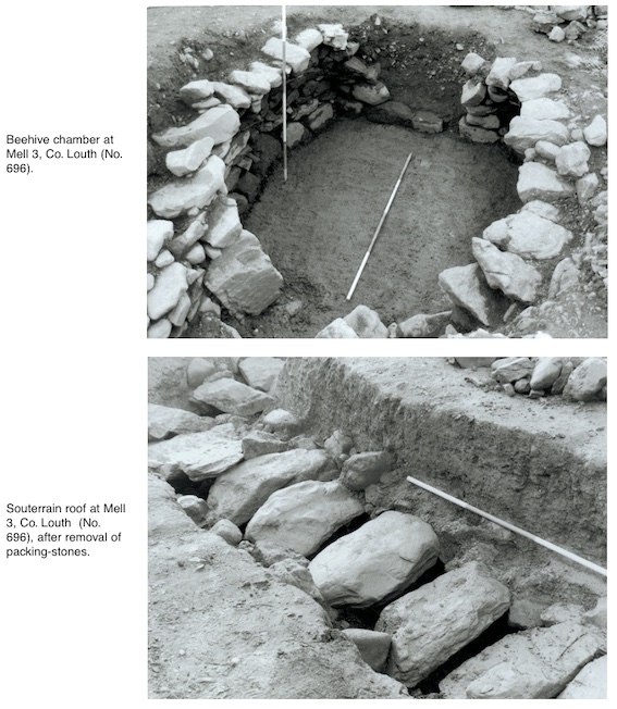
County: Louth Site name: MELL (3)
Sites and Monuments Record No.: N/A Licence number: 00E0631
Author: Thaddeus C. Breen, for Valerie J. Keeley Ltd.
Site type: Souterrain and Field boundary
Period/Dating: Multi-period
ITM: E 705750m, N 777227m
Latitude, Longitude (decimal degrees): 53.733958, -6.397205
The site, which is 4km north-west of the town of Drogheda, was discovered during monitoring of topsoil-stripping for the Northern Motorway. Two dark features were seen, and a small area collapsed in two places nearby, revealing the presence of a souterrain. The site was excavated between August 2000 and February 2001.
Souterrain
This was fully excavated. It was approximately L-shaped, with a beehive chamber at the lower end. The total length (extended) was 36.88m, of which the roof was intact for 11.6m. The floor sloped downwards from a shallow entrance. The average height of the roofed area was 1.1m, and it was 0.72m wide. The beehive chamber had collapsed in antiquity, but its walls survived to a height of up to 1.4m. There were no subsidiary passages, but there was one change in level. Approximately halfway along the souterrain was a step 0.45m high. The passage continued at that level for c. 3.76m, before dropping again. This may originally have been a step, but the area had collapsed in antiquity and simply sloped down. A drain ran under this raised area, evidently to prevent water from ponding up in front of the step. The water was not diverted out of the souterrain but continued into the lower part. The lowest layer in the beehive chamber was a 0.2m layer of fine clay, obviously deposited by successive flooding. In the unroofed part of the souterrain, north of the step, three isolated lintels survived. Two of these were ordinary flat lintels but relatively large, which is probably why they were left in situ. The third, at one of the corners of the souterrain, was placed on edge, with its largest surface vertical. The narrow edge would have protruded below the level of the other lintels, creating a hazard for intruders. No other features such as cupboards or air-vents were found. Apart from the clay layer in the beehive chamber, the fill of the souterrain consisted of either collapse, as in the beehive chamber, or deliberate backfilling, as in the unroofed part of the passage.
The latter was almost completely devoid of finds. The former contained a few finds, of very mixed dates, obviously from the ploughsoil. A piece of clay pipe stem was found in the collapsed material in the beehive chamber; a piece of green bottle glass and some sherds of Carrowkeel ware were found in collapsed material at one of the two points where the souterrain was first seen. A bronze mount decorated with openwork interlace was found in topsoil 70m from the souterrain while the site was being cleaned back.
Nearby features, possibly associated
A gully, 0.25m deep, ran parallel to the east–west part of the souterrain, turning southwards to echo the plan of the souterrain. This may have been a drain to prevent water running into the souterrain. The only trace of a structure near the souterrain was a series of six post-holes, four of which formed a straight, north–south line. The area immediately to the west had been disturbed by the construction of a water-tower in the 1970s. No evidence of date was found, nor could the structure be linked stratigraphically to any other feature on the site. It could not have extended as far as the souterrain entrance. No trace was found of a ringfort or similar structure enclosing the souterrain. Two of the ditches found (A and B, see below) could have been contemporary, but these were further down the hill and appeared to be field boundaries rather than enclosure ditches.
Ditch A
A patch of dark soil 27m south-east of the souterrain was found to be a V-sectioned ditch, 1.56m deep, 2–3.5m wide, running from east to west across the site for 24m. Its eastern end went beyond the take of the road and was truncated by preliminary construction work before the excavation. The fill consisted mostly of sterile clay resembling the subsoil. Above this was a shallow deposit of dark brown, sandy soil, which produced the only find from that feature, a piece of iron slag.
Ditch B
A similar dark patch was found 41.5m south of Ditch A. This was another ditch, running north-east/south-west. It was 29m long, 1.18m deep, 1.7–2.8m wide. Its eastern end curved northwards, but, like Ditch A, it had been truncated by construction work. The fill consisted of dark grey, sandy material, with darker, almost black, material underneath. Some twigs and animal bones were present. Finds included a lignite spindle-whorl, part of a lignite bracelet and a blue glass bead.
Ditch C
This came to light when the area beside the souterrain was trowelled back. It was beside the souterrain and was cut by it at one point. V-shaped in section, it was 1.6m wide and 0.7–2m deep. Like Ditch A, it seemed to have been backfilled with natural subsoil, and there was a darker layer on top. This layer contained a sherd of pottery, as yet unidentified, and some possible cremated bone.
Ditch D and occupation layers
At a distance of 20m south of the souterrain, a spread of darker soil was investigated. It contained pottery, possibly Neolithic, but this has not yet been confirmed. Flint flakes were found, mostly debitage. There were also traces of burning and a curvilinear V-shaped ditch, 0.6m deep and 1.5m wide. The surviving length was 13.11m (it had been truncated at either end by construction work).

13 Wainsfort Crescent, Templeogue, Dublin 6W