2000:0649 - COOLFORE (Site 1), Louth
County: Louth
Site name: COOLFORE (Site 1)
Sites and Monuments Record No.: N/A
Licence number: 00E0794
Author: Cóilín Ó Drisceoil, for Valerie J. Keeley Ltd.
Author/Organisation Address: 6 Riverview, Ardnore, Kilkenny
Site type: House - Neolithic
Period/Dating: Neolithic (4000BC-2501 BC)
ITM: E 704528m, N 780286m
Latitude, Longitude (decimal degrees): 53.761686, -6.414680
The site was found by Kieran Campbell during the monitoring of topsoil-stripping for the Northern Motorway (Drogheda Bypass). It lay beside a stream, on a gentle north-facing slope above a basin of fen-peat. Analysis of the peat formations suggests that the basin probably contained open water in prehistory. Excavations took place between 7 August and 22 December 2000.
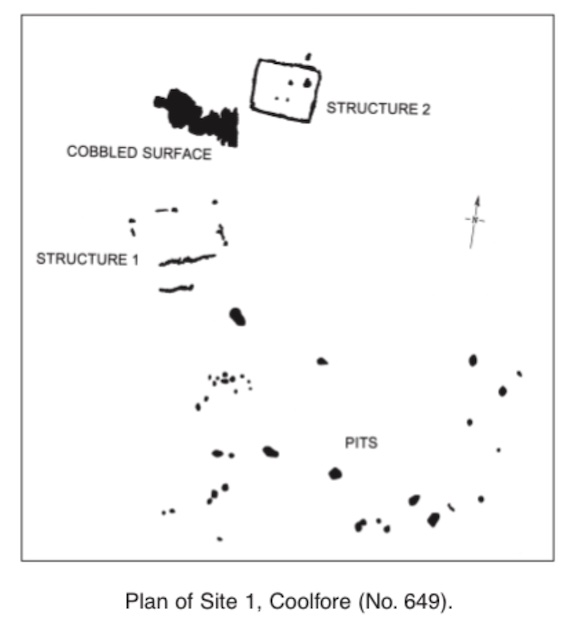
An area 50m x 40m was identified for excavation. Within this, two structures, a roughly cobbled activity area and 40 pits were found.
Structure 1 was the larger of the two structures, measuring 9.2m x 6m. It was found 9m to the south of Structure 2 and was aligned on a north-east/south-west axis. Three large post-holes on the north and an intermittent foundation trench formed the walls of the building. The trench, where it survived, varied in depth from 0.2m to 0.02m. The fill of this was a dark, charcoal-rich, silty clay containing heavily abraded sherds of ‘traditional’ carinated bowl pottery and burnt and unburnt flint flakes. There was no evidence for any carbonised wall materials. On the south side of the building, running parallel to the foundations, was a shallow trench containing a large quantity of ‘traditional’ carinated bowl pottery. This may be interpreted as a drip-trench. No features were found in the interior. The function of the structure is at present uncertain, though it seems likely that it is a badly damaged house.
Structure 2 was better preserved than Structure 1 and was 6m x 5.1m. It was aligned east–west on a different axis to Structure 1. The foundation trench varied in depth from 0.14m to 0.04m. Burnt planks were found at irregular intervals throughout its length. These were radially split and of oak (identification by Ingelise Stuijts). Baseplates were identified on the north and south walls. The trench was filled with mid-grey, clayey silt and large stones. Many of these were doubtless used as packing around the planks. Three post-holes, two pits and a possible hearth were identified in the interior. Sherds of ‘traditional’ carinated bowl pottery were found in the foundation trench fill.
An area of rough cobbling and ‘occupation’ deposits, measuring 9m x 4m, lay between Structures 1 and 2. It had a maximum depth of 0.5m. A large quantity of lithics and pottery were recovered from the area. The lithics included cores, flakes, debitage and retouched artefacts.
Most of the pits were found in a large area to the south of the two structures. Many of these may be interpreted as refuse pits or external hearths, though it is feasible, given the high quality of some of the artefacts, that a number of the deposits were ritually charged.
The form and arrangement of the site compare well with other excavated Early Neolithic settlements sites like Newtown, Co. Meath, Tankardstown, Co. Limerick, and Ballygalley, Co. Antrim (Gowen and Tarbett 1988; Gowen and Halpin 1992; Simpson 1996, 123–32). Based on artefact typologies, a date in the early fourth millennium BC is likely, though forthcoming radiocarbon results should refine this.
References
Gowen, M. and Halpin, E. 1992 A Neolithic house at Newtown. Archaeology Ireland 6 (2), 156.
Gowen, M. and Tarbett, C. 1988 Three Irish gas pipelines: new archaeological evidence in Munster. Dublin.
Simpson, D.D.A. 1996 The Ballygalley houses, Co. Antrim, Ireland. In T. Darvill and J. Thomas (eds), Neolithic houses in north-west Europe and beyond. Oxford.