2000:0638 - BALGATHERAN 1, Louth
County: Louth
Site name: BALGATHERAN 1
Sites and Monuments Record No.: N/A
Licence number: 00E0477
Author: Robert M. Chapple, for Valerie J. Keeley Ltd.
Author/Organisation Address: 20 Thalia Street, Belfast BT12 5PT
Site type: Excavation - miscellaneous
Period/Dating: Multi-period
ITM: E 704898m, N 778876m
Latitude, Longitude (decimal degrees): 53.748949, -6.409550
The site was discovered during licensed monitoring of topsoil-stripping on the line of the Northern Motorway, north of Drogheda, Co. Louth, for Meath County Council, carried out by Kieran Campbell for Valerie J. Keeley Ltd (see Excavations 2000, No. 714). The area investigated was c. 4800m2 and lay c. 2.4km south-south-west of Newtown Monasterboice village on the southern face of a low hill in gently rolling, open pastureland (c. 98.19m OD). The site possessed excellent views in all directions, especially to the south.
Prehistoric activity
Evidence of the prehistoric phase at this site was confined to a number of discrete pits and post-holes without any easily discernible pattern. Among these was a circular pit, which lay in the south-east of the site (0.6m x 0.4m x 0.12m deep). It contained a single deposit of grey-brown silt and produced eleven pieces of pottery (type as yet unidentified). This was truncated by a subcircular pit (0.6m x 0.6m x 0.2m deep). The upper layer (of two) was an orange-brown, sandy silt, which contained five pieces of flint. This in turn was cut by a subcircular post-hole, which contained a single fill of charcoal-rich, grey/black silt and produced four flints and six fragments of prehistoric pottery (0.23m x 0.18m x 0.14m deep).
Also in the south-eastern portion of the site was C180, a small circular pit (0.38m x 0.38m x 0.29m deep). The basal fill of brown-grey, silty clay produced a number of fragments of burnt bone, while its uppermost fill, a brown-grey, fine, sandy clay, also produced four flints. C182 was a circular pit, which lay 0.07m to the west of C180 (0.69m x 0.61m x 0.36m deep). The pit contained eight fills, which largely consisted of varying degrees of silty or sandy clay, all with a high proportion of charcoal and burnt clay. These fills combined to produce some 90 flints of variable workmanship, including two well-crafted scrapers. Finally, C101 was a subcircular pit, c. 1.5m east of C180 and C182 (0.8m x 0.7m x 0.31m deep). It contained five fills, four of which produced substantial quantities of charcoal and/or burnt bone. In all, C101 produced seventeen pieces of flint. While detailed analyses of this material have yet to be undertaken, it seems safe to interpret C182 and C101 as possible burial pits.
Early Christian activity
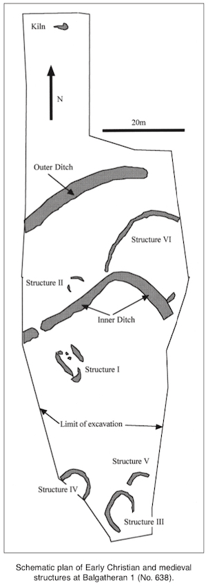
The Early Christian remains represented the largest single phase of activity within the site. These comprised a kiln, two large boundary ditches, a possible house foundation trench (Structure II), a petal-shaped field (Structure VI) and what is currently interpreted as a single-sided industrial structure (Structure I).
Outer ditch
The outer ditch, a large, curvilinear cut running generally north-east to south-west across the excavated area, lay 21.4m north of the inner ditch. The excavated portion of the ditch was 40m long with an average width of 3m and a depth of 2m. The cut ended in a rounded terminal c. 6m from the eastern edge of the site, but a corresponding terminal could not be located. In total, 24 fills were recorded from the ditch, most of which appeared as varieties of pale grey, silty clays and seem to represent a relatively long period of fluvial deposition. Three separate recuts of the ditch were evident. This feature had a projected diameter of 70m, which would have placed the return of the ditch to the south of Structure III, outside the area available for excavation and already surfaced before excavation began.
Inner ditch
This was a large L-shaped ditch, which ran for 39m across the excavated area (3m wide x 1.5m deep). It contained some 72 distinguishable fills within which a number of distinct phases may be identified. Firstly, the basal layers are interpreted as fluvial deposits, largely consisting of pale grey silts, which contained iron slag, a number of flints and fragments of burnt bone. A second phase, concentrated in the western terminal of the ditch, represented the dumping of various sandy and silty clays, which contained large quantities of iron slag along with residual flints and a single piece of a shattered rotary quernstone. Some 13m east of the eastern terminal of the ditch, and possibly contemporary with the dumping of the iron slag, a small stone-lined hearth was discovered in the ditch. This feature contained five fills of charcoal and burnt clay and produced a broken, blue glass bead. A post-hole associated with the hearth also produced burnt bone and a quartz crystal. Finally, the ditch was backfilled with redeposited subsoil, presumably derived from material from the bank.
At present the function of this ditch is unclear, as is its temporal relationship to the outer ditch. However, it may have acted as an internal division of the outer ditch rather than a complete enclosing element of the site.
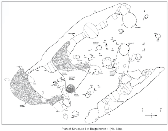
Structure I: industrial building
This was centrally located within the site and measured 7.37m north-west to south-east by 2.1m. The structural beams of the building were represented by a series of nine post-holes laid out in a roughly rectangular plan. One of these (C14) produced a small quantity of iron slag and a number of fragments of worked iron. The south-west side of this structure also produced a collection of approximately fifteen stake-holes, which are interpreted as forming a single wall, possibly in three consecutive phases, most likely of post-and-wattle construction. The south-eastern half of the building also had a gravelled surface, which extended outside to the south-west and south-east. The opposite half of the structure contained a number of refuse pits; one partially cut through a glacial erratic in the subsoil. Exterior to the structure, and on the same long alignment, were two linear cuts (c. 5m x c. 0.7m x c. 0.3m deep). These are interpreted as drip-trenches to carry away water from a thatched or shingled roof. These features were eventually filled with multiple layers of dark, charcoal-rich deposits and burnt clay.
Structure II: hut site
This structure, in the absence of dating evidence, is interpreted as the foundation trench for a possible Early Christian hut. The structure lay directly to the north of the inner ditch and is composed of two separate, short, arcing cuts (C667: 3m x 0.4m x 0.15m deep; and C633: 1.4m x 0.6m x 0.15m deep). Both cuts were filled with a stony, silty clay, and one had evidence of two post-holes cut into its base. Taken together they may represent a single structure with a diameter of c. 4m.
Structure VI: field enclosure
Located in the north-east of the excavated area, c. 5m east of Structure II, this was a curving linear cut, which formed a large sub-oval with projected internal dimensions of 21.2m north–south by 18.3m. The largest single extent of this possible field enclosure measured 30m long x 0.65m wide x 0.3m deep. Although no finds were recovered from the various fills, it is currently interpreted as a possible Early Christian feature and is stratigraphically later than the last recut of the inner ditch.
Kiln
A stone-lined kiln was recorded to the extreme north of the site, c. 49m north of the outer ditch. In plan it appeared as an oval with a narrow, short, linear opening to the west (2.6m long x 1.5m wide x 0.32m deep). Both the neck and base of the kiln were lined with a series of flat slabs. It contained eleven distinguishable fills, all of various forms of silty clay with high amounts of burnt clay and charcoal. The uppermost of these deposits yielded a single blue glass bead.
Medieval activity
Structure III: possible house
Although a number of the field ditches that cross the site may be of medieval date, the most convincing evidence of this period was three ditched enclosures (Structures III–V), of which Structure III was the most complete. This structure was represented by a linear cut (0.75m wide x 0.5m deep) forming a subrectangular enclosure with rounded corners. It measured 7m long (north–south) by 5.2m wide. This cut contained two fills, the lower of which appears to have been a redeposited natural; the upper fill was a brown-grey, silty clay with charcoal. This latter deposit produced thirteen fragments of medieval pottery, along with some quantities of burnt bone and animal teeth. Owing to a combination of ploughing and topsoil-stripping, any original occupational surface had been removed.
Structure IV: possible house
Only a semicircular portion of this structure survived, with a projected diameter of c. 6m, though it may have been of similar morphology to Structure III. The surviving cut was 1m wide x 0.09m deep and contained two fills. The lower deposit was largely composed of a red burnt clay; the upper layer contained large quantities of charcoal-rich soil and burnt clay.
Structure V: possible house
Located to the north-east of Structure III, this feature appeared as a 6m-long arc (0.4m wide x 0.15m deep). Owing to a number of post-depositional factors, only a small portion of the cut survived. The projected internal diameter of the structure would have been 4.8m, though the possibility that it was of a similar plan to Structure III cannot be discounted. The cut contained a single fill of grey-brown, stony silt with infrequent charcoal.