2000:0549 - RIVER NORE, Kilkenny, Kilkenny
County: Kilkenny
Site name: RIVER NORE, Kilkenny
Sites and Monuments Record No.: N/A
Licence number: 00D033
Author: Niall Brady, for Archaeological Diving Company Ltd, on behalf of Margaret Gowen and Co. Ltd.
Author/Organisation Address: 2 Vale Terrace, Lower Dargle Road, Bray, Co. Wicklow
Site type: Bridge, Weir - regulating and Mill - unclassified
Period/Dating: Multi-period
ITM: E 650596m, N 656308m
Latitude, Longitude (decimal degrees): 52.655599, -7.252175
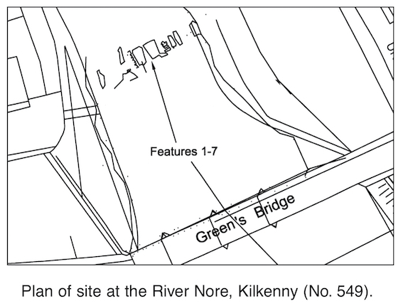
Initial underwater archaeological assessment in advance of the River Nore Flood Relief Scheme in Kilkenny involved the inspection of c. 2km of riverbed from a point upstream of Green’s Bridge in Kilkenny City to a point downstream of Fennessy’s Mill outside the city. The assessment served as the first underwater archaeological work to be carried out along this stretch of the river. Twenty-one sites and areas of archaeological potential were identified. The work considered the underwater levels of existing mill complexes. It identified a series of stone-built landing stages along Bateman Quay. It suggested the quarry location for stone that was used to construct Fennessy’s Weir.
The most revealing result was the identification of medieval bridge remains at Green’s Bridge and at John’s Bridge in the centre of the city. At the former site a series of ruined stone piers and collapsed arches survives across the riverbed upstream of the existing bridge on an alignment with Green Street. It is probable that the remains are those of the bridge mapped by Rocque in 1758, which was destroyed in the flood of 1763. At John’s Bridge the underwater assessment identified the ruined remains of four stone piers and associated lengths of collapsed arch. Cutwaters faced with dressed stone were observed on the upstream sides. One of the piers retained its arch-springing. A single timber pile was identified. This bridge is also the remains of the bridge mapped by Rocque and subsequently destroyed by flooding. The underwater assessment was able to identify the base of the two piers for the 18th-century bridge that replaced the medieval John’s Bridge. These are located immediately upstream of the medieval site, which lies under the existing bridge. Further work was carried out at John’s Bridge (see Excavations 2000, No. 538).