County: Kilkenny Site name: JOHN’S BRIDGE, River Nore, Kilkenny
Sites and Monuments Record No.: N/A Licence number: 00E0790, 00D033
Author: Niall Brady, for Archaeological Diving Company Ltd.
Site type: Bridge and Pier/Jetty
Period/Dating: Medieval (AD 400-AD 1600)
ITM: E 650722m, N 655913m
Latitude, Longitude (decimal degrees): 52.652042, -7.250365
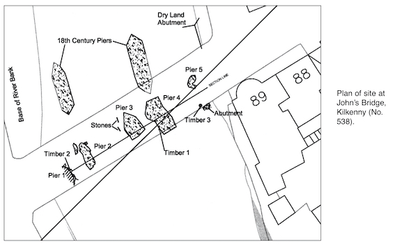
Initial underwater archaeological assessment in advance of the River Nore Flood Relief Scheme in Kilkenny identified the ruined remains of a medieval bridge and its 18th-century replacement below the existing John’s Bridge.
A further campaign of underwater work was undertaken at John’s Bridge to investigate the nature of the riverbed gravels surrounding the medieval piers and to investigate the full extent of those piers.
The work revealed additional information about the four stone piers observed in June. It also indicated that further bridge remains lie buried below the riverbed silts and shingle. Two timber piles were recorded and sampled for dating purposes, bringing the total number of piles observed to three. A fifth stone-built pier was located, along with an attendant stone abutment on the east bank. The indications are that the bridge remains are substantial. Further work is expected.

2 Vale Terrace, Lower Dargle Road, Bray, Co. Wicklow