2000:0422 - TONEVANE, Blennerville, Kerry
County: Kerry
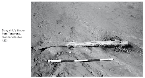
Site name: TONEVANE, Blennerville
Sites and Monuments Record No.: N/A
Licence number: 00E0233
Author: Karl Brady and Connie Kelleher, Eachtra Archaeological Projects Ltd.
Author/Organisation Address: 3 Canal Place, Tralee, Co. Kerry
Site type: Burnt mound and Wreck
Period/Dating: Multi-period
ITM: E 481488m, N 613007m
Latitude, Longitude (decimal degrees): 52.256002, -9.735902
Archaeological monitoring of dredging operations at Blennerville Port, Tralee, Co. Kerry, was requested by Dúchas The Heritage Service because of its high archaeological potential, based primarily on the high number of shipwrecks recorded for the area. Monitoring of dredging operations was carried out over a six-week period from the 14 March to 21 April 2000. During the dredging operation for the Jeanie Johnston Project, which also necessitated soil-stripping of areas for the dumping of the dredged material, three burnt mounds, a shipwreck and a number of artefacts were discovered.
The old port at Blennerville was being dredged in order to deepen the channel sufficiently so that a large barge could gain access to the Jeanie Johnston boatyard. The reconstruction Famine ship was to be moved onto the barge and brought to Fenit for further work. As some 20,000 tonnes of material was dredged, it was also necessary to strip a large area of land behind the boatyard to accommodate this material. An area of foreshore c. 80m x 80m was dredged to a depth of plus 1.7m—chart datum. The main area of dredging took place along the south side of the Lee in an area in between the windmill and Blennerville Quay, where the ship was eventually launched. A smaller area c. 80m x 20m along the northern edge of the Lee was also dredged.
Monitoring mainly took place in the foreshore in front of where the Jeanie Johnston was being built. Conventional dredgers were not used as it was too shallow, and tracked diggers could easily access the mudflats. Monitoring entailed the visual inspection of the excavation of the slobs (at low water) by diggers. The material was then dumped into large trucks. At low water the digger excavated the mud flats, revealing the natural stratigraphy in section, where it could be inspected visually for any evidence of archaeology. Any removal of material from in or near the riverbed produced late 19th- and 20th-century material—dumped animal carcasses, pottery, bottles and miscellaneous metal material.
As the dredged material was dumped it was selectively sampled, metal-detected and visually inspected. Sampling was carried out with diggers spreading selected lorryloads of muds in an area adjacent to the removal zone. The spread-out silt was then systematically metal-detected, washed down and visually inspected. This proved the most effective way to retrieve material. Finds were primarily of 19th- and 20th-century date.
A stray ship’s timber and a late 19th-century wreck, the Helena, were also identified during the dredging operation, protruding from the water at low tide some 20m directly to the west of the dredging zone. Closer inspection of the timbers identified them as part of the hull of a wreck. Mr Eddie Row, local historian, identified the vessel as the Helena, a rigged cutter built in Cork in 1853 for William Egan, then merchant at Union Quay. It had one mast setting gaff mainsail, a gaff-topsail, inner jib, outer jib and an optional flying jib. It had a square stern, was carvel built and had no figurehead. It was 48.6ft in length, stern to bow, and had a breadth to the outside planks of 14.6ft; its depth of hold from the upper deck to the ceiling at midship was 7.3ft. The builder was Michael Neil, who completed its construction on 20 November 1853; the vessel’s surveyor was Mr Bryan Adams. It appears to have been abandoned at the quayside in Blennerville sometime before 1894, as it was in this year that it was de-registered and would have then become a wreck.
The wreck is only visible at low water and lies in two pieces, apparently broken midship. The bow section appears to be located in the main river channel, with the hull lying to the north. The wreck is well embedded in the silt, with plastic and sand covering the exposed timbers.
A stray ship’s timber was also located on the slobs some 30m to the west of the dredging area and 15m from the wreck of the Helena. This was lifted because it was in danger of being impinged upon by the barge. It is a floor timber with tree nails, tree-nail sockets and iron-nail sockets. It is square in profile, 2m long and 0.15m wide. Both ends are flat, and the piece is in good condition. It is unlikely that it is from the Helena, and it probably came from a flat-bottomed vessel such as a barge.
Monitoring of topsoil-stripping was also carried out on two areas that lie to the south of the boatyard. Area 1 was highly disturbed, as it was crossed by the old Tralee–Dingle railway. Nothing of archaeological significance was revealed during monitoring of this area.
Monitoring of Area 2 revealed two partially uncovered possible burnt mounds located beside each other. The first was visible as a black spread of charcoal-rich soil and red sandstone, c. 25m x 12m. Immediately to the north-east of and at right angles to the main site a possible second burnt mound was uncovered, but as it was only partially exposed it is not certain if it belongs to the main mound. Both mounds were subject to small-scale testing and were sampled for dating. The burnt mounds were not affected by further topsoil-stripping and dumping, and both were covered with geotextile matting and reinstated.
During clearance of the boatyard compound a redeposited burnt mound was revealed. The original site had been destroyed during the building of the craft centre some years ago, and the burnt mound material was redeposited to help form an even ground surface in the compound. It now remains visible as a discrete layer of charcoal-rich soil with a large quantity of heat-shattered red sandstone. This was recorded and sampled.
Post-excavation work is still ongoing.