2000:0387 - BOLLINGBROOK FORT, Seán Mulvoy Road, Galway, Galway
County: Galway
Site name: BOLLINGBROOK FORT, Seán Mulvoy Road, Galway
Sites and Monuments Record No.: SMR 82:83
Licence number: 00E0534
Author: Dominic Delany
Author/Organisation Address: 31 Ashbrook, Oranmore, Co. Galway
Site type: Bastioned fort
Period/Dating: Post Medieval (AD 1600-AD 1750)
ITM: E 530431m, N 726338m
Latitude, Longitude (decimal degrees): 53.282799, -9.043240
Excavation commenced here in July 2000 and is nearing completion at the time of writing. The excavation was undertaken at the request of the site owners to achieve archaeological resolution of the site in advance of a proposed carpark extension.
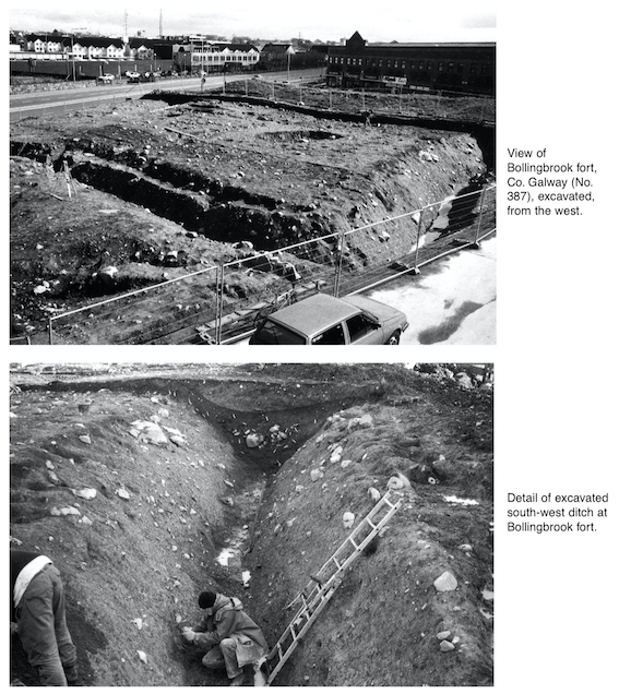
Bollingbrook was the most northerly of three star-shaped forts erected by Cromwellian forces to blockade the town of Galway during the siege of 1651–2. The forts were built on a prominent north-east/south-west ridge along which ran the medieval approaches to the town. A second, larger fort stood on the site of the present ‘New Cemetery’ in Bohermore, and the third was located close to the junction of College Road and Lough Atalia Road. The forts were connected by linear earthworks, thus forming a continuous defensive bulwark stretching from the Terryland River to the Lough Atalia shoreline. The siege-works were abandoned following the surrender of the town in April 1652. They were repaired in 1690, but the Jacobite defenders of the town decided not use them as a defence against the advancing Williamite forces in 1691. The Williamites, however, may have used them as a base camp for their final assault on the town, which surrendered within a few days of their arrival. Following the surrender the properties were parcelled out among the victors, and John Bollingbrook gained possession of lands on the eastern outskirts of the town. In time these lands were called Bollingbrook Parks, with the name eventually transferring to the fort.
The 1651 pictorial map of Galway depicts Bollingbrook as a quadrangular, stone-faced, earthen fort with bastions at each of the corners. Ordnance Survey maps indicate that the fort survived relatively unscathed into the late 19th century, but by the mid-20th century only the south-eastern section remained intact. The extant remains comprise a linear earthen bank (c. 30m north-east/south-west), with traces of bastions at its angles with the north-east and south-west sides. This recently conserved section of the fort is located on property adjoining the excavation site. The excavation site itself was extensively disturbed during the construction of an access road for a proposed commercial development in 1991. Test excavation was undertaken at that time by Hannah Kieley, to determine the extent of damage to the monument and to establish the archaeological limits of the site (Excavations 1991, 20, E631). Subsequent pipe-laying and road-widening schemes have caused further damage to the monument. Upon consideration of these factors, it was decided that full excavation was the only practical method of archaeologically resolving the site.
The excavation has clearly established the full extent of the 17th-century fort, which measures c. 28m2 from rampart crest to crest. It is defined by an impressive external fosse, 4.8m wide and 2.3m deep, with slight traces of a levelled internal rampart, c. 4.5m wide. The base of the fosse is filled by a fine silt deposit, which probably accumulated during the life of the fort. This is overlain by a series of mixed deposits representing various stages of backfilling and silting. The backfilling of the fosse was achieved by a gradual levelling of the ramparts. The topsoil occurs close to the top of the fosse and is overlain by a redeposited fill representing the final phase of backfilling, which appears to have occurred in the mid-20th century.
Internal features of the fort include a large subcircular pit, a shallow drainage ditch, a hearth and two concentrations of post-holes. The origin and function of the pit, which measured 6m x 5m and 0.9m in depth, are unknown, and the almost complete absence of finds from this feature was unusual in the context of the site. The drainage ditch, 1.25m wide and 0.4m deep, extends north-west/south-east across the interior of the fort and continues beyond the north-west fosse. It appears to date from the construction phase of the fort. The post-hole concentrations occur close to the south and west corners of the fort. They do not form any readily identifiable structures but may be associated with temporary encampments or activities associated with occupation of the fort. It is also possible that they are related to some form of rampart revetment or access to the corner bastions. The hearth undoubtedly served a domestic function (i.e. as a cooking area), but it is also likely that musket balls were produced in this area. This is suggested by the large numbers of musket balls that were found in the immediate vicinity of the hearth.
Contemporary finds from the fort include a wide range of iron, copper and lead artefacts, including musket balls, coins, buckles, nails, pins, knives, horseshoes, stirrups, a cannonball and a possible spearhead. Domestic refuse is well represented by large quantities of animal bone, seashells and potsherds. Some of the pottery wares appear to pre-date the 17th century, suggesting activity in this area prior to the construction of the fort. The most intriguing find of all was the fragmented portion of a Bronze Age vase or urn, which was embedded in the subsoil at the north-east end of the fort. There was no burial evidence, but a small fire-pit, 1m x 0.8m and 0.25m deep, discovered nearby, may be associated with the vessel.
It is proposed to include a more detailed account of the excavation in next year’s bulletin.