County: Dublin Site name: DALKEY: 2A St Patrick's Road
Sites and Monuments Record No.: RMP 23:023012 (adjacent to) Licence number: 00E0633
Author: D.L. Swan and Stephen Johnston, Arch-Tech Ltd.
Site type: Castle - unclassified
Period/Dating: Post Medieval (AD 1600-AD 1750)
ITM: E 726450m, N 726933m
Latitude, Longitude (decimal degrees): 53.277633, -6.103913
Testing was undertaken on the site of a proposed development at No. 2A St Patrick’s Road, Dalkey, on 23 and 24 August 2000. The site is immediately north of the possible location of the 16th-century urban tower-house known as ‘the House Castle’, one of seven castles recorded in Dalkey by the mid-17th-century Books of Reference for the Down Survey. The site occupies the second plot north of Castle Street on the eastern side of St Patrick’s Road.
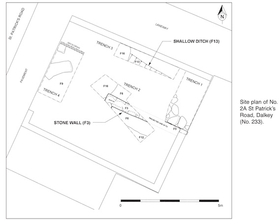
Four small test-trenches were dug within the site, which has dimensions of 5.5m north-north-east/ south-south-west by 8m.
Two substantial mortared stone walls (F3) identified in Trenches 1 and 2 appear to constitute the north-western corner of the foundations and lowest courses of a small building (4.5m west-north-west/east-south-east) set c. 3m back from the line of St Patrick’s Road. These are well-made random rubble walls with elements of rough coursing and squared corner blocks (0.5m wide, maximum height of coursed foundations 1.3m). The walls are orientated on slightly different axes than the most recent buildings on and around the site. These walls appear to correlate well with the size and position of a probable 19th-century structure shown on W.C. Carmody’s Dalkey Township Map (ascribed to 1863) but have characteristics that might equally suggest construction in the 18th century.
The post-medieval date of most of the pottery recovered from the foundation trench of F3 strongly argues against this structure having been associated with the original occupation of the House Castle but does not rule out a connection with the reputed conversion of the castle into a large house in 1765. In his 1770 account of Dalkey, Peter Wilson describes how ‘...one of the castles has been repaired and by means of additional buildings, converted into a commodious habitation’ and places it at the east end of the town, adjacent to the Common.
Successive layers of construction rubble identified abutting and overlying the walls are consistent with the pattern of 19th- and 20th-century rebuilding and renovation suggested by both the extant building fabric on the site and analysis of available historical sources. A dark organic deposit encountered across the site at c. 22.7m OD represents the earliest layer noted, with a range of finds that support an 18th/early 19th-century date. The characteristics of this layer would be consistent with its formation in a yard or garden behind a Castle Street property, an interpretation supported by a possible shallow drainage ditch at the north of the site. This organic layer directly overlay the natural subsoil, a compact, light grey, sandy clay, which was encountered at c. 22.5m OD. The presence of a single sherd of medieval pottery in the backfill of the foundation trench of F3 indicates some limited medieval activity on the site, potentially disturbed by post-medieval construction.

32 Fitzwilliam Place, Dublin 2