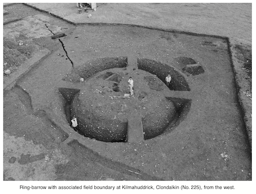
County: Dublin Site name: KILMAHUDDRICK (Grange Castle International Business Park), Clondalkin
Sites and Monuments Record No.: N/A Licence number: 00E0448
Author: Ian W. Doyle, Margaret Gowen & Co. Ltd.
Site type: Barrow - ring-barrow
Period/Dating: Bronze Age (2200 BC-801 BC)
ITM: E 704348m, N 731691m
Latitude, Longitude (decimal degrees): 53.325186, -6.433615
The initial detection of this ring-barrow by geophysical survey was confirmed by archaeological assessment under licence 00E0263 (See Excavations 2000, No. 223). Excavation commenced in July for a period of eight weeks, during which time the ring-barrow and several adjacent features were excavated.
The ring-barrow was located in Field 108, a large field at the centre of the area designated for the biotechnology campus buildings. The topography is generally level at c. 68m OD. However, the south-eastern corner of the field contains a natural raised area measuring c. 60m east–west x 150m. This area is generally 2m higher than the surrounding topography. The ring-barrow was sited in this slightly elevated position.
The ring-barrow was not visible prior to the geophysical survey or archaeological testing. Following stripping, a dark, circular band of charcoal-rich, black, ditch fill was visible, with a spread of cremated bone in the interior. A series of linear features skirted the eastern side of the ditch. Excavation of the ditch fills revealed a well-stratified sequence of deposits in a ditch 2.5m wide at the top and 0.25–0.3m wide at the base. The ditch cut had a depth of 1.6m below the level of natural subsoil and measured c. 13m in external diameter.
The uppermost fills of the ditch, F4 and F5, contained occasional fragments of burnt bone, charcoal and mollusc shells. Although occasional fragments of burnt bone were recovered from these ditch fills, no coherent or discrete cremation deposits were detected. Fragments of a human skull were recovered from the upper fill. A central fill of mid-brown, silty clay in the ditch sealed a series of stone features. F15 and F16, in the western quadrant, were large limestone blocks resting in the base of the ditch. Charcoal deposits were present on the flat upper surfaces of these stones. Oxidised clay patches against the sides of the ditch, adjacent to these stones, indicate that fires had been lit on these boulders in the ditch.
In the northern quadrant of the ditch, at the base, a stone ‘cist-like’ structure with a capstone was revealed. This was composed of medium-to-large angular stones leaning inwards at an angle of c. 45o. A large, angular capstone was positioned at the apex of the inward-leaning stones. Several of the stones comprising this small structure were fire-reddened, though there were no indications of in situ burning. When excavated, this structure was empty. Some 2m to the east of this structure, at the base of the ditch, a limestone pillar was revealed. This stood upright to a height of 0.62m and had a width of 0.44m.
Within the circular area enclosed by the barrow ditch, several deposits of cremated bone were visible. A small spread of cremated bone was initially apparent, and this may indicate disturbance. Upon excavation this was found to seal a shallow depression filled with frequent inclusions of powdered cremated bone fragments. To the north-west of this, a pit measuring some 2.1m north–south x 0.6m was revealed. This pit contained occasional fragments of cremated bone and appeared to cut an irregularly shaped cremation pit (F87), which measured 1.3m east–west x 0.5m and had a depth of 0.8–0.9m. The upper fill of this was a hard, compact, grey clay with occasional stones. This fill sealed a layer of cremated bone and charcoal. A sherd of pottery was recovered from this material, the characteristics of which all point to an Early Bronze Age date for its manufacture, specifically a Beaker or Food Vessel background (Anna Brindley, pers. comm.). What appears to be a small black bead was retrieved, during sieving, from this deposit.
Two undated pits were excavated adjacent to the barrow. A series of linear features was also revealed in the area surrounding the ring-barrow. These are interpreted as the remains of field boundaries and were found to enclose the ring-barrow in a subrectangular field system. These remain undated. A geological seam was traced running from the north side of the barrow.
Some 50m to the east of the ring-barrow a trench was reopened in Field 109 to examine features originally detected during assessment 00E0263 (see Excavations 2000, No. 223). A northern return of the field system found to enclose the ring-barrow was revealed. This places the ring-barrow in a rectangular enclosure measuring c. 50m east–west x 100m (minimum). A metalled surface was found to seal the field boundary in this trench. While the field boundary system remains undated at the time of writing, it is likely to post-date the ring-barrow. A hearth was also excavated.
Analysis of the soil samples from the ring-barrow has recovered evidence of cereal production. Charred remains of barley, wheat and oats were identified in the ditch fills and cremation deposits. Traces of hazel, haw and sloe were also found. Post-excavation analysis of the human remains, the faunal remains and the charcoal samples is ongoing.
A cluster of ring-barrows is located on the upland area of Saggart Hill and Verschoyles Hill, approximately 6km to the south of the Kilmahuddrick site. Within this group, the Lugg monument complex, which contained a ring-barrow, was excavated by Kilbride-Jones in the late 1930s. The Kilmahuddrick barrow may be a northern element of this distributional cluster, or, alternatively, its presence in a heavily ploughed lowland area may indicate a greater survival rate and higher level of visibility in the upland areas.

2 Killiney View, Albert Road Lower, Glenageary, Co. Dublin