2000:0208 - GLEBE SOUTH, Balrothery, Dublin
County: Dublin
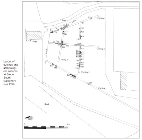
Site name: GLEBE SOUTH, Balrothery
Sites and Monuments Record No.: RMP 5:57
Licence number: 00E0034
Author: Christine Baker, Arch-Tech Ltd.
Author/Organisation Address: 32 Fitzwilliam Place, Dublin 2
Site type: Field boundary
Period/Dating: Medieval (AD 400-AD 1600)
ITM: E 719933m, N 761364m
Latitude, Longitude (decimal degrees): 53.588414, -6.188477
Pre-development test excavation took place at this site, which is on high ground sloping steeply to the west and south-west on land adjacent to St Peter’s Church and graveyard, the former Glebe house and grounds and the later medieval tower-house. Five cuttings were opened, three extending north–south and two positioned laterally.
The principal concentration of archaeological activity is in the north-eastern quadrant of the site, which is also the most elevated portion. In total 48 features were identified, which can be divided into medieval and post-medieval activity.
There were two distinct foci of medieval activity. Area 1 comprised a broad curving ditch (F42), which produced stratified medieval pottery dating from the mid-12th to 14th centuries. It was cut by a later ditch (F4) and flanked by another (F43) of undetermined date. Area 2 comprised a spread of burning (F9) associated burnt clay (F46), a stone structure (F19) and a series of ditches (F7, F8, F21). The fill of F19 has produced stratified medieval pottery, the majority of which is Leinster cooking ware (mid-12th to 14th centuries). The stone structure appears to be just 2m wide, limiting the possibilities of usage. However, it is clearly associated with the burnt clay.
In total fifteen sherds of medieval (Caroline Sandes, pers. comm.) and one sherd of post-medieval pottery were recovered.