County: Clare Site name: KNOCKSAGGART (Site AR85/86)
Sites and Monuments Record No.: N/A Licence number: 00E0416
Author: Ken Hanley, on behalf of Valerie J. Keeley Ltd.
Site type: House - prehistoric and Cremated remains
Period/Dating: Prehistoric (12700 BC-AD 400)
ITM: E 650949m, N 656293m
Latitude, Longitude (decimal degrees): 52.655435, -7.246953
Site AR85/86 incorporated a c. 36m x c. 56m area, between NGR 139176 167025 and 139216 167000, in the townland of Knocksaggart, Co. Clare. The site was located on north-sloping ground, overlooking the large prehistoric, multi-phased site, Area EX1, at Carrigoran, excavated by Fiona Reilly (Excavations 1999, 14–15, 98E0338 and 98E0426). AR85/86 was identified during monitoring by Christine Grant (Excavations 1999, 9, 99E0350) of pre-construction topsoil-stripping, in advance of the N18/N19 Road Improvement Scheme from Ballycasey to Dromoland.
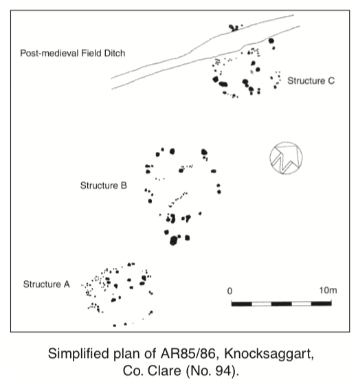
Initially, the site was identified as a possible hearth with associated pits, including a suspected cremation pit. An extended site clearance revealed localised burnt spreads and a more widespread array of pits and post-holes. The site was excavated between 19 June and 14 August 2000. The excavation revealed three substantial structures in an apparent alignment.
Structure A
This, the southernmost structure, was difficult to interpret. The exposed features revealed a subcircular cluster of stake-holes, post-holes and pits. Most of the excavated features cut directly into the underlying subsoil, and it proved difficult to determine a chronological sequence for many of the exposed features. An initial assessment suggested the presence of a subcircular structure, with an angled northern-western end and a circular/curved south-eastern end. However, a more detailed examination of the excavated evidence may suggest the presence of a rectangular house 6.2m north-east/south-west by 2.6m, comprising c. 34 stake-holes and c. 12 post-holes, with an additional circular/curved feature c. 5.2m x c. 3.1m attached to its south-east. Internally, the ‘rectangular’ house contained several large post-holes (roof supports?), one of which (C.575) produced a sherd of coarse prehistoric pottery. There was also some evidence of a small internal division/screen wall formed by an array of smaller stake-holes. A large pit (C.255), located within the north-eastern end of the structure, also produced a single sherd of coarse prehistoric pottery (report pending).
Structure B
This circular structure measured c. 7m in diameter and was the best preserved of the three. It was constructed with an outer perimeter of 23 post-holes and six stake-holes. A plano-convex rubbing stone (with evidence of wear) was reused in one of the perimeter post-holes (C.1248). At least three possible token cremations were identified within three separate post-holes, near the suspected entrance to the south of the structure. The ‘entrance’ consisted of an annex or porch-like feature c. 1.2m by c. 2.2m. Internally, the structure was subdivided or screened off by two separate internal partitions, represented by two linear arrays of smaller stake-holes.
Structure C
Structure C measured c. 6.7m north–south x c. 6.3m and was to the north-east of Structure B. Part of the northern end of the structure was truncated by a post-medieval field ditch, though the surviving remains showed a subcircular structure, with a perimeter comprising fifteen stake-holes (including two wattle holes) and fourteen possible post-holes. There was also evidence for an internal partition/screen, represented by a linear array of smaller stake-holes. A small hearth (C.853) and a possible cremation pit (C.1179) were also identified near the centre of the structure. A possible entrance, formed by two double post-holes located c. 60cm apart, was identified at the southern end. Another cremation pit (C.801) was identified to the west, immediately outside Structure C. This also produced part of a trapezoid-shaped saddle quern.
At the time of writing post-excavation analysis was still ongoing.

44 Eaton Heights, Cobh, Co. Cork