2000:0092 - KNOCKAUN (SIte AR31), Clare
County: Clare
Site name: KNOCKAUN (SIte AR31)
Sites and Monuments Record No.: N/A
Licence number: 00E0415
Author: Ken Hanley, on behalf of Valerie J. Keeley Ltd.
Author/Organisation Address: 44 Eaton, Heights, Cobh, Co. Cork
Site type: Burnt spread
Period/Dating: Undetermined
ITM: E 540288m, N 664729m
Latitude, Longitude (decimal degrees): 52.730353, -8.884068
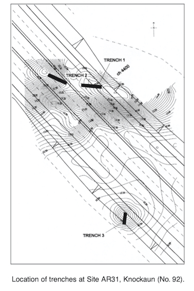
Site AR31 consisted of three prominent mounds in the north-west corner of a field in the townland of Knockaun, Co. Clare. It was identified as a site of archaeological potential during an environmental impact assessment, in advance of the N18/N19 Road Improvement Scheme, from Ballycasey to Dromoland. The site lies within the take of the proposed road, and further archaeological investigation was warranted. Testing was carried out on 15 and 16 June 2000.
The site comprised two adjoining prominent mounds (12.3–16.8m OD and 12.3–15.9m OD), with a third, lower (12.5–13.4m OD) mound c. 60m to the south-east. Three test-trenches were manually inserted. Test-trench 1 measured 10m east–west x 1.5m and ran up the western slope of the most eastern of the two main mounds. Topsoil consisted of mid-/dark brown, stony clay, with frequent spreads of orange and black ash, the result of recent removal of gorse. Beneath this was c. 0.05–0.15m of grey, silty sand (C4). This covered most of the trench and rested on yellow/brown, silty, sandy natural subsoil. Two localised and shallow (c. 30mm) spreads of grey clay (C5 and C6), with very occasional flecks of charcoal, were identified. These features were potentially archaeological, but testing proved inconclusive. A possible cut feature (0.23m east–west x 0.15m x c. 0.16m deep) was identified next to C6. It was filled by sterile, mid-/dark orange/brown, sandy clay, which was similar to natural subsoil.
Test-trench 2 measured 10m north-west/south-east x 1.5m and was located across the eastern slope of the most westerly of the two adjacent mounds. This revealed a similar stratigraphy, with topsoil and C4 resting directly on the natural subsoil. In places where there were natural depressions in the underlying subsoil, C4 was quite deep (c. 0.22–0.3m). Outcrops of natural bedrock were exposed in several places.
Test-trench 3 measured 6m north–south x 1.5m and cut across the lower, isolated mound. This mound, c. 14m in diameter, was relatively circular and uniform in plan. Topsoil consisted of 0.03–0.1m of gritty clay, which rested on 0.05–0.15m of redeposited, yellow, silty sand subsoil. This sealed 0.1–0.25m of buried topsoil, which was composed of dark brown, silty sand. Once removed this revealed the natural subsoil.
Overall, C5 and C6 from Trench 1 were potentially archaeological. Trenches 2 and 3 failed to reveal any features of archaeological significance. Archaeological monitoring of topsoil-stripping was recommended.