2000:0087 - KILLULLA (Site AR27), Clare
County: Clare
Site name: KILLULLA (Site AR27)
Sites and Monuments Record No.: N/A
Licence number: 00E0345
Author: Ken Hanley, on behalf of Valerie J. Keeley, Ltd.
Author/Organisation Address: 44 Eaton Heights, Cobh, Co. Cork
Site type: Burnt mound and Enclosure
Period/Dating: Undetermined
ITM: E 539999m, N 665119m
Latitude, Longitude (decimal degrees): 52.733825, -8.888416
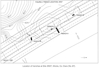
Site AR27 consisted of a series of earthworks and a low, collapsed wall situated between NGR 140135 164900 and 140143 164844, in an area of overgrowth, in the north-west corner of a field in the townland of Killulla, Co. Clare. It was identified as a site of archaeological potential during an environmental impact assessment carried out in advance of the N18/N19 Road Improvement Scheme from Ballycasey to Dromoland (O Rahilly 1995, 11). Because the site lies within the take of the proposed road, further investigation was warranted.
Testing was carried out between 29 May and 8 June 2000. The site comprised a series of banks and platforms, with a possible banked enclosure (under heavy overgrowth) to the north and a low wall flanking the eastern side. Four test-trenches were inserted, two (Trenches A and C) across a prominent bank and platform area, a third (Trench D) across the possible banked enclosure and a fourth (Trench B) across the low wall. Test-trench A measured c. 8m east–west by 1.5m and revealed a large black mound of heat-shattered angular stone (C.2), immediately below topsoil. Test-trench C revealed part of the same burnt mound. Test-trench B, located c. 25m to the south-east, measured 4m east–west by 1.5m. It exposed a collapsed and undated wall (C.3), inserted into a (possible) low, eroded clay bank (C.4). A thin layer of buried topsoil (C.5) separated this from a (possible) lower eroded bank (C.6). The latter bank rested on a buried topsoil horizon (C.7), which produced some animal bone. Trench D, located c. 27m north-west of Trench A, measured 3.2m north-west/south-east by 1m. It revealed a 0.56m-high bank of upcast, grey, stony, sandy clay (C.9), with a collapsed internal stone revetment (C.13). These sealed buried topsoil deposits (C.11 and C.12). The bank appeared to form a possible enclosure under heavy overgrowth. No finds were recovered. Full archaeological excavation of the identified archaeology was recommended.
Reference
O Rahilly, C. 1995 Environmental impact study on the route of proposed N18/N19 improvements. Unpublished report. Limited distribution.