2000:0036 - BALLYCONNELL, Cavan
County: Cavan
Site name: BALLYCONNELL
Sites and Monuments Record No.: N/A
Licence number: 00E0639
Author: Finola O’Carroll, Cultural Resource Development Services Ltd.
Author/Organisation Address: Campus Innovation Centre, Roebuck, UCD, Belfield, Dublin 4
Site type: No archaeology found
Period/Dating: N/A
ITM: E 627241m, N 818703m
Latitude, Longitude (decimal degrees): 54.116665, -7.583338
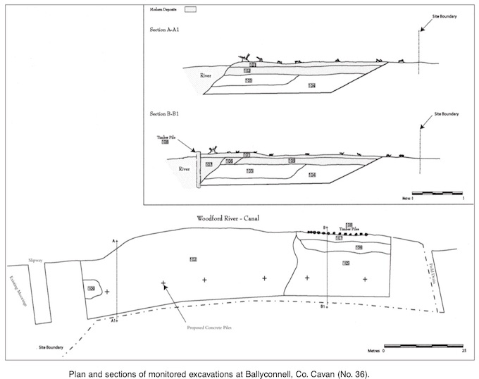
Monitoring of earth removal along the Woodford riverbank took place before an extension of the public mooring at Ballyconnell, Co. Cavan, on behalf of Waterways Ireland. The site consists of a riverside strip, located within a larger field. It is 19m wide and 120m long. The actual area where soil removal occurred measures 100m x 15m.
Soil removal was undertaken using a tracked excavator with a toothless ditching bucket, removing the riverbank in three 5m-thick strips. Each strip was excavated in earthfast cells, which—in ideal conditions—allowed observation of relatively dry sediments to a depth of 1.5m. In wetter conditions flooding occurred, such that sediments could only be observed when removed in the bucket. The cell trenches were not entered, because of safety concerns. Sediments were excavated to a depth of 3m.
The bulk of material encountered appeared to be a series of modern dump deposits, which overlay a peat layer. The natural peat layer lay at an average depth of 0.8–1.4m below the modern surface, but it dropped sharply, creating a 2.4m-deep hollow, along the 10m-wide stretch adjacent to the river. The peat layer contained occasional naturally occurring tree stumps and brushwood. The hollow along the riverbank was filled at some stage, perhaps naturally, with a layer of light-coloured sandy gravel containing some patches of grey marl. This layer was on average 1.1–1.6m thick and was encountered at a depth of 0.8–1.4m below ground level. The peat and sandy gravel layers were covered by clearly modern dump deposits.
The northern two-thirds of the site was covered by a 1.1m-thick layer of silty, brown clay, encountered at a depth of 0.3m below the surface. It contained modern felled timber. The topsoil contained a large amount of modern rubbish.
The southern third of the site experienced a more complicated dumping phase. The riverbank was consolidated by a revetment of 3m-long timber piles, which retained a 2.4m-deep and 2m-wide deposit of brown, topsoil-type material. This gave way, inland, to a discrete dump of orange marl, measuring 2m wide and 0.6m deep. An extensive 0.6m-thick layer of black clay, with a high organic content and containing modern plastic, covered the rest of the area. This was covered by a 0.2–0.3m-thick layer of topsoil. Nothing of archaeological significance was recorded.
It was agreed with Dúchas The Heritage Service that sediments removed from the site would be subjected to metal-detecting. This was impractical at the time of dredging, owing to space constraints. All earth was transported to a nearly field for drying. When dry, it will be spread and metal-detected under licence.