1999:844 - DUNGARVAN: Carberry's Lane, Waterford
County: Waterford
Site name: DUNGARVAN: Carberry's Lane
Sites and Monuments Record No.: SMR 31:4
Licence number: 99E0115
Author: Dave Pollock, ArchaeoGrafix
Author/Organisation Address: Church Lane, Stradbally, Co. Waterford
Site type: Town defences
Period/Dating: Post Medieval (AD 1600-AD 1750)
ITM: E 626298m, N 593076m
Latitude, Longitude (decimal degrees): 52.088981, -7.616245
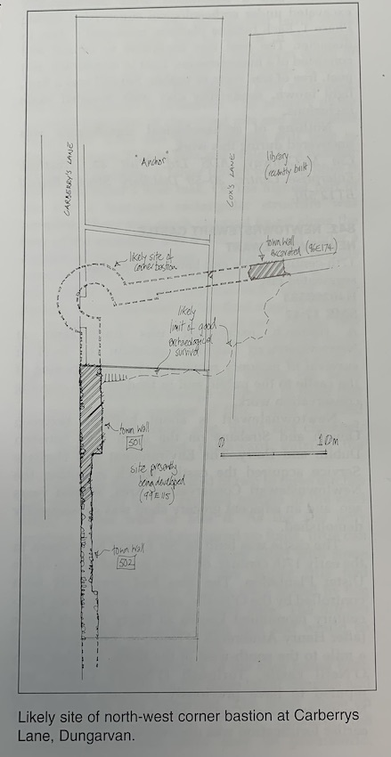
An open site between Carberrys Lane and Coxs Lane, at the edge of the walled town of Dungarvan, was assessed in April 1999, before redevelopment. Further investigation took place in July and August.
The town wall ran the length of the site, with its base down the side of a linear clay pit (floored with beach cobbles and used as a road to the shore) under Carberrys Lane. The wall could not be dated from finds, but the construction (drystone foundations with mortar poured in sporadically) was similar to that of lengths of wall elsewhere, and it was dated by pottery to the 17th century. A shallow and narrow cellar was cut against the wall and backfilled in the early 18th century (remains of the building overhead were removed in the late 18th or early 19th century), when the town wall was demolished and a long quay was built at the edge of the harbour. Although the entire site was truncated repeatedly, in the 18th and early 19th century, the pre-town wall ground level has survived in a narrow strip at the north end of the site, where the ground falls suddenly onto the medieval beach. This implies good preservation for the corner bastion, 10m away under the adjoining site.