1999:804 - SLIGO: 6–7 Abbey Street, Sligo
County: Sligo
Site name: SLIGO: 6–7 Abbey Street
Sites and Monuments Record No.: N/A
Licence number: 99E0471
Author: Donald Murphy, Archaeological Consultancy Services Ltd.
Author/Organisation Address: 15 Trinity Street, Drogheda, Co. Louth
Site type: Historic town and Graveyard
Period/Dating: Multi-period
ITM: E 569461m, N 835886m
Latitude, Longitude (decimal degrees): 54.270871, -8.468839
A rescue excavation was carried out for Dúchas between 13 September and 8 October 1999 on the site of a proposed new visitor centre at Sligo Abbey. The site is immediately to the west of the nave of the church belonging to Holy Cross Priory, which was founded in 1252 by Maurice Fitzgerald, second baron of Offaly, who was regarded as the founder of Sligo town. It is the burial place of O’Connor of Sligo and was occupied until 1698, when the site was granted to Sir William Taafe. Despite this, the friars continued to occupy a section of the abbey until 1760, when Fr Laurence Connellan decided to move elsewhere. Some repairs to the ruins were carried out by Lord Palmerston, who erected railings and removed several houses in 1849–50.
Excavation of the north-west corner of the site behind an existing 19th-century house revealed a loose, brown loam containing stones and rubble with some shell and animal bone extending to a depth of 1.5–2m, resting directly on natural boulder clay. This probably represents 18th/19th-century fill deposited in order to bring this area to the same level as Abbey Street. A ditch 2m wide by 1m deep was cut into the orange/brown boulder clay running east-west to the rear of the 19th-century house; no finds were recovered from the fill, but charcoal samples produced a date of 1165–1276 for the infilling of the ditch. As burials were discovered to the south on the opposite side of Abbey Street, this ditch may represent an enclosure for a cemetery. Three small furrows were visible to the north of the ditch, aligned west-north-west/east-south-east, varying from 0.8m to 0.4m wide and 0.09m to 0.3m deep.
Three pits were uncovered. One, 1.9m in diameter, cut into the natural boulder clay at the northern baulk and was filled with loose, dark brown soil to a depth of 0.94m. A pipe stem indicates a post-medieval date. A second, larger pit was filled with brown loam and rubble, along with disarticulated animal and human bone, and measured 10m east-west by 5m. Finds from the fill suggest that this pit may have been dug to accommodate the construction of the buildings to the north and supported a late 18th- to early 19th-century date. The third pit was found below the foundation of the north wall of the 19th-century house and was cut into natural boulder clay. It contained a grey/brown loam and disarticulated human bone.
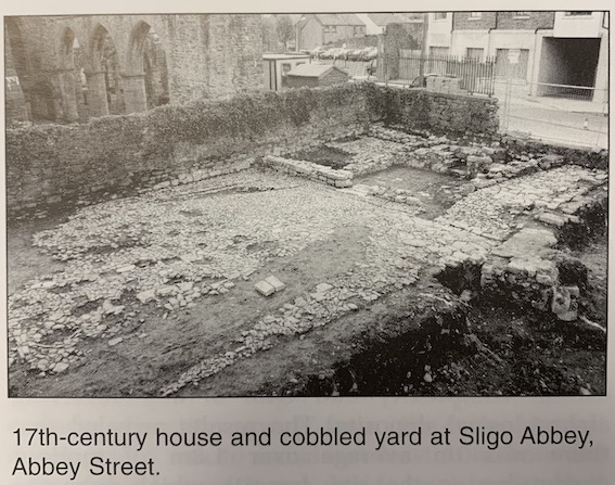
Removal of the overburden over the eastern half of the site revealed an extensive cobbled surface at a depth of 0.6–0.7m, together with the substantial foundations of an earlier house in the south-east corner of the site adjacent to the 19th-century house along Abbey Street.
A narrow cobbled laneway was revealed between the two houses leading to what presumably had been cobbled backyards. Variation in the cobble size and orientation suggests that the western portion of the cobbled surface represents a roadway shown on Luttrell’s town plan of 1689. The laneway between the houses may contain some fabric of this original road, as the alignment of the west wall of the earlier house follows the line of the 1689 plan. This house is shown on a 1791 illustration of the abbey by Grose. The north wall contained a doorway and an original sill, and a semicircular red brick fireplace was built into the south-west corner of the largest room of three.
The excavations revealed several phases of activity from the medieval period, represented by the ditch cut into the natural boulder clay, to the post-medieval period, represented by the house and cobbled yard.
Analysis of the human bone revealed the presence of at least eight individuals identified as probably three female, three male and two indeterminate. One of the female skulls had a number of weapon wounds on the frontal bone made with a thin knife. Absence of healing indicates that they were fatal, possibly even a case of murder.
The greatest impact from the development will be in the western half of the site, where the proposed new building is to be constructed. This necessitated the excavation to natural boulder clay in this area. In contrast, there will be little or no impact on the eastern half of the site, and the features exposed here will be incorporated into the development.