1999:715 - TRIM: Haggard Street, Meath
County: Meath
Site name: TRIM: Haggard Street
Sites and Monuments Record No.: SMR 36:28
Licence number: 99E0142
Author: Clare Mullins
Author/Organisation Address: 31 Millford, Athgarvan, Co. Kildare
Site type: Historic town
Period/Dating: Multi-period
ITM: E 680057m, N 757033m
Latitude, Longitude (decimal degrees): 53.557105, -6.791699
Archaeological excavation of a c. 90m length of pipeline trench was carried out along the western side of Haggard Street, Trim, during June and July 1999. Excavation took place before pipe-laying and following the identification during monitoring of the pipeline of what appeared to be a relatively complex archaeological stratigraphy at the southern end of the street. Throughout much of the monitoring project, which encompassed Mill Street, High Street and Haggard Street, a cobbled or metalled road surface was visible in the trench sections. This appeared as a relatively continuous layer, c. 0.2m deep, of a very stony and compact material, usually lying upon the natural and following a horizontal course at varying depths beneath the modern ground surface. Where this layer occurred at a deeper level it tended to be overlain by a silty, organic material and/or a dry, brown, clayey gravel, interpreted as representing a single episode of deliberate road-heightening. Occasionally a later episode of cobbling was identified closer to the modern road surface. Some sherds of medieval pottery were found in association with the earlier cobbled layer, but it was generally not associated with complex structural evidence (see No. 720, Excavations 1999).
At the southern end of Haggard Street the archaeological deposits became more complex. A large pit was transected by the pipeline, but it could not be established whether this pre-dated or post-dated the stony layer. North of the pit a linear stone feature that seemed to be too flimsy to represent a wall and that may be some form of kerbing was identified in section. Following the excavation of a manhole in the same area, a stratigraphy of c. 1.5m depth of archaeological deposits became visible on both sides of an area previously disturbed by a service pipe. At this point further trench excavations in the area were suspended pending excavation of what appeared to be an area of high archaeological sensitivity.
The excavation was divided into three sections, apportioned approximately evenly along the length of the trench; this strategy was designed to permit continued access to the carpark on Haggard Street on the western side of the line of the excavation. Excavation commenced in the central area and was completed before moving on to the area to the north. Finally, the southernmost stretch was excavated. A layer of cobbling (Road Surface 2), interpreted as representing a continuation of that identified in other areas of the town, proved to be a constant feature along the entire length of the excavation trench. The exposure of the surface of this layer provided an opportunity to examine its character as a road surface. It was somewhat denuded in places, but where best-preserved it appeared as a level surface of densely packed stones, placed to achieve as smooth a surface as possible. Though generally angular in form, the exposed, upper part of the stones was noticeably more rounded that the hidden underside. Throughout the excavation trench this layer was c. 0.2m deep and was usually overlain by 0.2–0.3m of a black, silty, organic deposit that produced medieval pottery and one fairly complete medieval leather shoe, as well as several fragments.
Towards the northern end of the excavation trench the eastern edge of a shallow gully that had been cut into the natural was identified beneath the cobbled surface. This ran parallel to the street line for several metres, widening eastwards as it travelled north, before descending to form a deep pit. A later gully cut through the earlier one at a right angle to the street line. Both gullies and the associated pit were sealed by the stony surface.
The most archaeologically sensitive area proved to be the southern end of the excavation trench, closest to the point at which the pipe-trench had originally been halted. Here the opportunity was provided to examine a short stretch of a later layer of cobbling (RS3) that pre-dated a modern layer (RS4). The cobble layers (RS2 and RS3) were separated by a depth of c. 0.4m of material consisting of a black, silty, organic deposit, generally lying directly over the cobbles, and an orange/light brown clay-a repetition of the stratigraphic pattern observed in the more northerly areas of the excavation trench, as well as in other parts of the town.
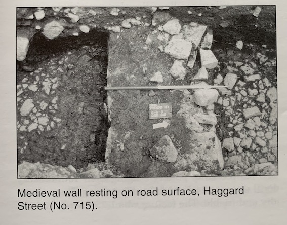
Not far from the southern end of the trench a mortared limestone wall was found that rested directly upon the earlier layer of cobbles (RS2). This wall was aligned in an east-west direction, at a right angle to the line of the street. It was 1m wide with facing-stones on its southern side and a rubble core. It seems likely that facing-stones originally lined the northern side of this wall, which would give it an original width of c. 1.3m. The wall survived to only one course in depth, and there was no foundation cut for it. This wall had clearly gone out of use at the same time as the cobbled surface upon which it rested, as the organic, black layer that overlay the cobbles also sealed the remaining course of the wall.
A foundation layer of silty sand containing a large volume of bone and wood underlay the cobbled layer (RS2) to a depth of c. 0.3m at the southern end of the trench. This layer may have been deposited to level up the area in preparation for the laying of RS2, as it diminished gradually in thickness moving north.
The vestigial remnants of what appeared to be another masonry wall were found at the extreme southern end of the trench, beneath this foundation layer of silty sand. This wall was aligned approximately north-south and was represented by a row of five possible facing-stones surviving to two courses. These stones rested upon a deeper cobbled surface composed of small stones (RS1), which was traced over a distance of at least 15m at the southern end of the trench. This wall was also constructed without a foundation trench. The layer of small cobbles was c. 0.1m deep and lay upon the natural.
It would appear that the cobbled layer, denoted as RS2, is the contemporary of the cobbled layer found in other parts of the town. It is certainly the same layer as that encountered immediately beyond the limits of the excavation to both the north and the south.
Finds from the excavation included a crutch-headed stick-pin, horseshoes and horseshoe nails, a copper-alloy chain and one fairly complete leather shoe.