1999:708 - RANDALSTOWN, Meath
County: Meath
Site name: RANDALSTOWN
Sites and Monuments Record No.: SMR 25:1, 25:2, 25:3, 18:26
Licence number: 98E0352
Author: Donald Murphy, Archaeological Consultancy Services Ltd.
Author/Organisation Address: 15 Trinity Street, Drogheda, Co. Louth
Site type: Fulachta fia
Period/Dating: Prehistoric (12700 BC-AD 400)
ITM: E 684919m, N 771968m
Latitude, Longitude (decimal degrees): 53.690520, -6.714264
An excavation was carried out in the townland of Randalstown, Co. Meath, on four fulachta fiadh discovered during monitoring of topsoil-stripping within the Northern Borrow Area, during construction of Stage 4a of the Tailings Dam Extension for Tara Mines Ltd. The excavation was carried out between 1 and 16 June 1999.
Topsoil extending to a depth of 0.4m was removed, revealing the yellow, natural glacial till beneath. A number of filled-in ditches of old field boundaries were exposed as areas of soft ground within the natural glacial till. Archaeological features were exposed at the southern end of one such boundary as spreads of burnt stone and dark soil highlighted against the natural clay, characteristic of levelled burnt mounds of fulachta fiadh. For the purposes of excavation these were divided into four archaeological areas.
Area 1 was revealed as a spread of burnt stone and charcoal-stained soil forming an approximate triangle measuring 8m by 5m. A rectangular trough 1.75m long, 1.65m wide and 0.58m deep was revealed at the eastern edge of the burnt mound spread. The top of the trough was sloped, with vertical sides towards the base, suggesting that it may have been lined with wooden planks. A squared recess 0.2m wide was cut into the natural clay in the south-east corner and may have secured a wooden upright. However, no post-holes were evident in the subsoil at the base of the trough. The spread of heat-shattered stones extended to the north-west from the trough and lay in an irregularly shaped hollow that was 0.25m deep. A large, subcircular pit measuring 1.7m by 1.3m was excavated to the north-west of the trough and was filled with burnt stones. This pit was 0.55m deep and had a broad U-shaped profile with sloping sides and a round base. Two further, subrectangular shallow pits were excavated to the east of the trough.
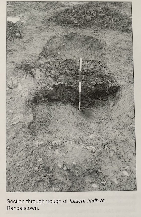
Area 2 was exposed as a large spread of burnt mound material consisting of a dense concentration of shattered stone and black silt measuring 12m north-south by 4m. This had a maximum thickness of 0.28m and lay within a hollow cut into the natural clay. The trough was exposed beneath the eastern edge of the burnt material and was an elongated subrectangular pit cut into the natural clay, measuring 2.5m by 1.1m and 0.44m deep. The fill was a black, charcoal-flecked silt that was the same as the burnt mound material. The remains of a wooden plank lay lengthwise along the base of the trough and measured 1.4m by 0.32m. No trace of wood was observed on the sides of the trough, and no post-holes were visible in the base. A large pit 1.2m in diameter was exposed to the south-west of the burnt spread and contained a weathered, natural fill and occasional burnt stones.
Area 3 was a spread of black, sandy silt with burnt stone over an area measuring 13.5m by 5.5m. This had a maximum thickness of 0.38m and overlay a soft, wet, grey silt up to 0.15m thick containing charcoal flecks and burnt stones. This in turn lay above the natural, yellow glacial till. The trough was on the south side of the burnt stone spread and consisted of a flat-bottomed subcircular pit cut into the natural glacial till measuring 1.8m by 1.7m and 0.55m deep. A deposit of wet, black silt, 0.1m thick, was exposed at the base of the trough below a number of layers of natural silt. No evidence was observed for a wooden lining, which may have been considered unnecessary by the builders because of the impermeable clay sides. A bucket-shaped pit cut into the natural glacial till was exposed 0.5m north of the trough and was filled with a black, silty clay with charcoal and burnt stone. The pit measured 1.2m by 1m and was excavated to a depth of 0.56m.
Area 4 was a thin spread of burnt stone covering a small trough and two small pits. The burnt material was spread over an area measuring 15m by 10.5m. A dense concentration of shattered stone and black silt c. 2.5m in diameter marked the location of the trough. The trough measured 1.8m by 0.5–1m. A shallow U-shaped gully or hollow c. 0.25m wide and 50mm deep was exposed along the centre of the trough. This hollow may have held a wooden plank that was removed when the trough went out of use. Two possible stake-holes, c. 80mm in diameter, which may have secured a plank along the base, were exposed at the south end of the trough. A third stake-hole was exposed within a slot-like feature at the north-east of the trough. Two further possible stake-holes were also exposed at the surface. Two small pits were revealed 10m to the east of the trough. Both were subcircular in plan, measuring c. 0.6m in diameter and 0.26m deep, and were filled with wet, grey, silty clay containing charcoal and burnt stone.
At least four fulachta fiadh were excavated at Randalstown, along with a number of pits probably associated with their use. These conform to the general size range of other excavated troughs. There was surviving evidence for a wood lining in the trough in Area 2, with indirect evidence for a lining in the troughs in Areas 1 and 4. The fills of the trough in Areas 2 and 3 indicate a gradual silting-up over time, whereas the troughs in Areas 1 and 4 contained a homogeneous fill suggesting backfill in one operation. The presence of such a concentration of fulachta fiadh is a strong indication of significant Bronze Age activity in the immediate area and reinforces the evidence found at Simonstown for a densely populated prehistoric landscape.