1999:681 - DULEEK: Larrix Street, Meath
County: Meath
Site name: DULEEK: Larrix Street
Sites and Monuments Record No.: SMR 27:15
Licence number: 99E0464
Author: Deirdre Murphy, Archaeological Consultancy Services Ltd.
Author/Organisation Address: 15 Trinity Street, Drogheda, Co. Louth
Site type: Ecclesiastical enclosure
Period/Dating: Early Medieval (AD 400-AD 1099)
ITM: E 704422m, N 768623m
Latitude, Longitude (decimal degrees): 53.656940, -6.420219
An assessment was carried out on the site of eight proposed dwelling-houses, associated services and an access road. The site is on the south side of Larrix Street, Duleek, Co. Meath, within an area of archaeological potential as identified in the Urban Archaeological Survey of County Meath, and is a recorded monument. An Early Christian monastic site and enclosure are evident in the present street pattern around Duleek.
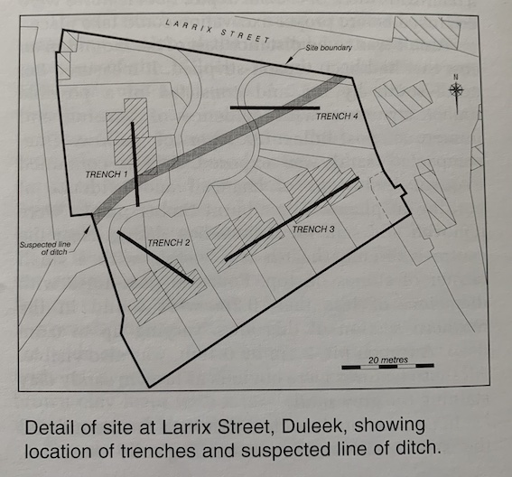
Four test-trenches were excavated by machine. Trenches 1–3 were excavated within the area of the proposed houses, and Trench 4 was excavated parallel to Larrix Street, crossing the line of the earlier ditch.
Trench 1 was excavated north-south to the west of the site and measured 19m by 0.7m. The sod and topsoil extended to a depth of 0.2m and lay above a post-medieval, light brown, dauby clay, which in turn lay above the natural boulder clay at a depth of 0.36m. At the south end of the trench a section of ditch was exposed extending in a south-west to north-east direction; it was at least 3m wide but extended southwards beyond the trench. The ditch was 1m deep and was visible at a depth of 0.3m below the surface. A small dump of loose stone was exposed at the north side of the ditch, which may have formed part of a collapsed drystone wall. Two sherds of 19th–20th-century pottery were recovered from the sticky, brown clay fill.
Trench 2 was excavated in the south-west corner of the site, measured 20m by 0.7m and was excavated to a maximum depth of 1.2m. A layer of light brown, sticky, moist clay was exposed at a depth of 0.3m below the sod and topsoil. This contained a single clay pipe stem, extended to a depth of 0.4m at the east end of the trench and 0.9m at the west end and lay directly above the natural boulder clay. No features were evident, and no other finds were recovered.
Trench 3 was excavated to the south of the site, measured 34m by 0.7m and was excavated to an average depth of 0.65m, with one section excavated to a depth of 2.2m. The sod extended to a depth of 0.14m and overlay a layer of fine, brown, sandy clay that contained three fragments of post-medieval pottery and a single rimsherd of unglazed medieval ware. This layer extended to the top of the natural boulder clay at a depth of 0.4m. A section of ditch was exposed c. 6m from the east end of the trench, extending in a north-west/south-east direction. It was visible below the fine, brown, sandy clay and had been cut into the natural boulder clay. It was 1.8m deep, 2.7m wide at the top and 1m at the base. The fill was a grey, boulder-clay-like, wet clay, and no finds were recovered.
Trench 4 was excavated in a roughly east-west direction close to the existing entrance to the site, measured 20m by 0.7m and was excavated to a depth of 0.6m except where the ditch crossed the trench, where it was excavated to a depth of 1.6m. The sod extended to a depth of 0.2m and overlay a layer of fine, light brown clay. This in turn overlay the natural boulder clay at a depth of 0.3m. A section of ditch was exposed c. 5m from the east end of the trench. This appeared to extend in a south-west/north-east direction and was presumably part of the ditch that was uncovered in Trench 1. The ditch was cut into the natural boulder clay and was exposed directly below the light brown clay. It was 1.3m deep and 5m wide. All the finds recovered from the dark grey, heavy clay fill were modern in date.
Trenches 2 and 3 failed to reveal any archaeological stratigraphy, and the natural boulder clay was exposed at an average depth of 0.4m. The ground above appears to have been heavily ploughed, thereby obliterating any features that may have existed. All the finds recovered were relatively modern in date, with the exception of a single sherd of medieval ware. However, this came from a disturbed context. The ditch exposed at the end of Trench 3 may relate to the Early Christian enclosure but in all likelihood is not an enclosing ditch but an old field drain.
The ditch exposed in Trenches 1 and 4 would appear to follow the line of the Early Christian enclosure. However, this ditch appears to have been interfered with in the north-east corner of the site towards Larrix Street. Human memory records the presence of a drain in this area of the site, and the ditch was probably backfilled early in the early 20th century, as indicated by the relatively modern finds that were recovered. It is clear, therefore, that, while the ditch follows the line of the Early Christian enclosure, it has been altered in the north-east corner, where it was probably used as a drain.
The proposed development will impinge slightly on the enclosing ditch, and it was recommended that the sections of the ditches that will be disturbed by the proposed house foundations be excavated and that all ground disturbance works associated with the development be monitored.