1999:677 - BELLEWSTOWN, Meath
County: Meath
Site name: BELLEWSTOWN
Sites and Monuments Record No.: SMR 36:34
Licence number: 99E0520
Author: Deirdre Murphy, Archaeological Consultancy Services Ltd.
Author/Organisation Address: 15 Trinity Street, Drogheda, Co. Louth
Site type: Hearth, Structure and Mound
Period/Dating: Multi-period
ITM: E 675415m, N 754772m
Latitude, Longitude (decimal degrees): 53.537473, -6.862301
Owing to quarrying by the owner of this site, a rescue excavation was carried out. The site was initially inspected by Michael Moore of Dúchas on 4 August 1999, who noted two ditch-like features in the southern face of the area that had been quarried. By the time the licence was issued those features had been destroyed. The site, a recorded monument, is classified as a mound 6.5m in diameter and 1.1m high surmounting a hillock of sand c. 8m high.
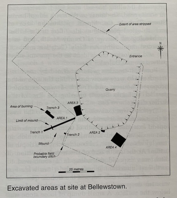
Three trenches were hand-excavated in the remaining section of the mound in the south-west quadrant of the hillock. Trench 1 was 24m long, 1.1m wide and 4.8m deep. A 0.1m layer of sod and topsoil overlay an orange/grey, sandy ploughsoil varying from 0.2m to 0.3m thick. The mound material, an orange, sandy clay, was exposed at a depth of 0.6m and extended to a depth of 0.8m. Apart from a cluster of large stones, this trench contained no features or finds.
In Trench 2, topsoil had been stripped right up to the eastern edge of the mound, exposing a ditch feature cut into the sand. The trench was excavated westwards through the mound and was 1.5m long, 1m wide and 1m deep. The ditch was 1.75m wide with an average fill depth of 0.3m, consisting of brown clay loam with a few small stones. No finds were recovered from this trench.
Trench 3 was 2.1m long, 2.1m wide and 0.8m deep. It was opened along the western part of the mound. Sod and topsoil extended to a depth of 0.45m and overlay a uniform layer of brown, dauby soil (0.42m thick) that contained a stone feature running east-west, 2m long and 0.5m wide, tapering to 0.2m at its west end. A hearth and several pits were exposed. The hearth measured 1.3m by 1.1m and contained fragments of bone and a probable tooth. A charcoal sample was taken for radiocarbon dating.
In Area 1 the remains of a stone structure of probable late medieval origin were exposed by topsoil-stripping east of the mound in the south face of the quarry. It was 1.7m long by 0.6m wide, constructed of limestone rubble and bonded with mortar. A layer of debris was visible on the floor of the quarry, probably representing the demolished wall. A bone and a 17th-century button were recovered from this debris. No further finds or features were recovered in this area.
Area 3 was a ditch and pit to the north-east of the mound, visible in the south-west face of the quarry. The features were cleaned back, revealing a semicircular pit with a stony, yellow/grey sand and a 0.05m-wide ditch of c. 0.3m depth. Both features were destroyed before proper excavation could take place.
Area 4 was some distance east of the mound in an area that had been topsoil-stripped. It measured 8m north-south by 6m and consisted of a possible timber structure with evidence of burning and numerous post-holes. A layer of yellow, fine, compacted sand was exposed, which contained frequent inclusions of charcoal and evidence of burning in places. Three burnt timber planks were removed and sent for radiocarbon dating. Near the centre a circular hearth was visible with a small cluster of stones on top. Fourteen post-holes with diameters of less than 0.2m were found in the northern section of this area, varying up to 0.5m deep. A trench pit, 2.1m by 0.16m, was also visible. All these features were obvious as brown, sandy clay staining the grey sand.
In conclusion, it is clear that both the mound and the sandy hillock are archaeologically sensitive. Indeed the areas to the east and west of the site are likely to contain other deposits. The results of this partial excavation suggest that this monument is in fact a burial mound. However, the site is under a direct threat from quarrying. It was therefore recommended that no further work be permitted on the hillock or in the immediate area.

