1999:640 - KNOCKABBEY, Thomastown, Louth
County: Louth
Site name: KNOCKABBEY, Thomastown
Sites and Monuments Record No.: SMR 11:80
Licence number: 99E0260
Author: Edmond O'Donovan, Margaret Gowen & Co. Ltd.
Author/Organisation Address: 2 Killiney View, Albert Road Lower, Glenageary, Co. Dublin
Site type: Castle - tower house
Period/Dating: Multi-period
ITM: E 692726m, N 798729m
Latitude, Longitude (decimal degrees): 53.929597, -6.588055
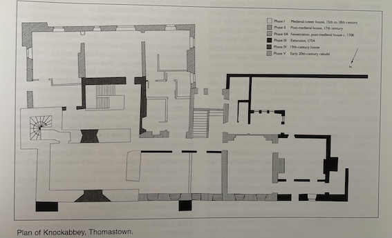
Monitoring was carried out at Knockabbey, Thomastown, Co. Louth, in July and August 1999. Knockabbey is the former residence of the Bellews, the Tennisons and the O’Reillys, and the estate house is made up of five phases of building and alteration, dating from the 15th to the 20th century.
Phase I, medieval, c. 15th/16th century, is the construction of the tower-house. Phase II, post-medieval, around the mid-17th century, is the construction of a T-shaped building to the west of the tower-house and the subsequent enlargement of the fenestration (Phase IIa, c. 1700). Phase III, around the mid-18th century, is the renovation of the T-shaped building. Phase IV, around the mid-19th century, is the construction of new wings to the south and east of the tower-house; and Phase V, c. 1925, is the rebuilding of the southern range and the interior of the tower-house after an extensive fire.
This monitoring relates to the Phase I building, which was subject to renovation work between July and August 1999. The focus of the monitoring was on the removal of the flagged floor at ground-floor level in the tower-house, to prevent rising damp. The flagged floor was relaid in situ after the insertion of a new damp-proof course.
Plasterwork was removed from the internal walls in the upper floors of the tower-house, and portions of the external, rendered, six-bay facade of the 17th-century T-shaped building fell away to reveal evidence of the early fenestration of the building. It is suggested that, stylistically, the fenestration is Queen Anne in date (c. 1700).
The monitoring at ground-floor level in the tower-house revealed that natural boulder clay formed the foundation for the tower-house. A relatively uniform layer of clay that may have formed an earlier floor surface pre-dating the flagstones overlay the natural clay; however, no datable finds were identified. The surface of the possible clay floor was altered and overlain by sand and mortar layers that formed the bed for the stone-flagged floor. These deposits included red brick and stone that indicated a terminus post quem for the floor in the post-medieval period. The surface below the sand and mortar layers was rough, and no evidence for occupation (charcoal flecking etc.) was revealed during the monitoring.

