1999:590 - DROMISKIN, Louth
County: Louth
Site name: DROMISKIN
Sites and Monuments Record No.: SMR 12:47
Licence number: 99E0330
Author: Donald Murphy and Malachy Conway, Archaeological Consultancy Services Ltd.
Author/Organisation Address: 15 Trinity Street, Drogheda, Co. Louth
Site type: Graveyard, Road - unclassified togher and Platform - peatland
Period/Dating: Multi-period
ITM: E 705334m, N 797341m
Latitude, Longitude (decimal degrees): 53.914726, -6.396619
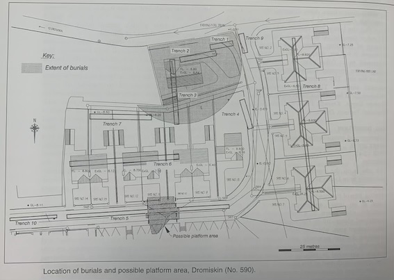
The site is on the south side of the road leading eastwards from Dromiskin village, lying south of the former ecclesiastical enclosure (SMR 12:46). The curving line of the roadway probably represents the trace of an inner enclosure around the early monastic site. There is a substantial amount of marshland along and to the south of the proposed development area, which probably formed a natural boundary for the monastic site to the north. The proposed development incorporates the site of cist burials discovered in 1862 in the west corner of a field to the south-east of the monastic graveyard.
Two stages of assessment were carried out. Stage I was undertaken by Donald Murphy between 20 and 22 July 1999, consisting of thirteen test-trenches, of which four revealed archaeological potential. The grave-cuts of at least six west-east-aligned burials were revealed in Trench 3, a possible wooden trackway in Trench 4, and a wooden platform or trackway in Trench 5. Artefacts recovered included a sherd of local medieval ware from the top of a possible pit in Trench 6. The Stage II assessment was undertaken to verify the nature, context and extent of the trackway and platform features revealed in Trenches 4 and 5 respectively. This work was carried out by Malachy Conway under an extension to the licence, between 29 October and 4 November 1999.
Trench 3 was excavated to a depth of 0.3m, revealing natural, grey silt (OD 8.34m) into which had been cut at least six west-east-aligned graves. The burials appeared to have been cut into a sandy, brown loam 0.5–0.1m thick, which overlay the natural, grey, silty sand. All six grave-cuts were fairly regularly spaced, c. 1.5–1.8m apart, and were 1m wide. The presence of stones along the edges of three grave-cuts, at the northern end of the trench, indicates possible long cists. The graves are all concentrated in the area of a slight hillock in this corner of the site, and it is likely that the cemetery originally extended further west below the adjoining houses and perhaps north under the road towards the cemetery itself. The burials did not continue further to the south into the wetter, marshy ground. At the south end of the trench a very shallow ditch was exposed, which may have been the original extent of the cemetery. The only find recovered from the trench was a small body sherd of Beauvais, which came from the topsoil above the graves. The ditch at the south end of the trench was extremely shallow, just 0.15m deep, and it is possible that it represents a later plough furrow rather than an enclosing feature around the burials.
Trench 4, measuring 12.5m by 2m, was excavated north-south along the modern field boundary. The trench was excavated to a depth of 1m (OD 7.1m), at which point a series of timbers was exposed along the eastern side of the trench, lying in a north-south direction. These appeared to consist of some irregular planks up to 0.43m wide apparently laid on irregularly placed branches that sat on a peaty soil. Re-excavation in Stage II extended the trench a further 16.5m south to examine deposits and stratigraphy in this area. Measuring 29m north-south by 1.7m, Trench 4 was excavated to a depth of between 1m (7.1m OD) and 1.25m. Fragments of butchered animal bone were recovered from the interface of the brown loam that overlay the peat deposit. At this level a roughly north-south-running field ditch (0.7m wide and 0.6m deep), parallel to the existing hedge line, ran for a distance of 9m from the north end of the trench.
The possible wooden trackway feature uncovered in Stage I was found to consist of branches and wood fragments apparently dumped or washed into the upper fill of the hedge-line ditch. A series of roundwood branches (birch and possibly alder) and fragments of tree roots was found irregularly set into the water-saturated peat fill of the ditch, flanked along its western margin by a mixed deposit of grey, gravelly clay, compacted peat and limestone. No ancient dressed timbers or planks were uncovered. Fragments of butchered animal bone and a sherd of early modern pottery were recovered from the upper fill of the ditch, which also contained small twigs, leaves and possibly reeds or rushes to a depth of 0.6m. The south end of the ditch terminated at an area or deposit of waterlogged peat, and it is possible that the ditch operated as a water channel or drain into a naturally wet and marshy area along the eastern side of the field. The material is clearly naturally accumulated debris and waste within a boundary ditch. A fallen tree stump, possibly of oak and associated with several fragments of animal bone, was found across the line of the trench, 23.5m from the northern end.
Stage I, Trench 5, measuring 64m by 2m, was excavated west-east. Natural, grey, silty sand was exposed at the west end of the trench at a depth of 0.65m (OD 7.47m). The top 0.2m of the trench consisted of sod and topsoil over a brown loam with small stones, 0.25m deep. A rimsherd of medieval local ware was recovered from this loam, which possibly represents medieval/post-medieval ploughsoil over this part of the site. This brown loam sat directly on a loose, brown, peaty clay 0.2m deep, which in turn overlay natural, grey, sandy silt. A fragment of a medieval tile with green/brown glaze was recovered from this layer.
At a distance of 15m from the west end of Trench 5 a layer of grey, stony, sterile clay was exposed, sitting directly on the peaty layer and below the ploughsoil. This layer was c. 0.2m deep towards the middle of the trench. The natural, grey, sandy silt was exposed at a much deeper level over the eastern end of the trench, and the brown, peaty layer became far more extensive. It is possible that the grey, stony layer was purposely deposited above the peat on what was formerly wet ground, to consolidate the ground for use. There is a substantial drop in ground level to the south of Trench 5, where the ground is extremely wet. At a distance of 30.5m from the west end of the trench, a series of timbers and branches was exposed sitting on the peat at a depth of 1.1m (OD 6.4m) and was found to extend eastwards for 10m.
Stage II excavation over the area of this possible trackway or platform, to a maximum depth of 1.3m, revealed a sequence of topsoil 0.2m deep over brown loam, with small stones towards the base of the deposit, 0.25–0.35m deep. The upper level of the peat deposit (6.7m OD) was characterised by irregularly arranged branches and root fragments, mainly of birch, as well as possible reeds or rushes. Much of this material was both fragmented and compacted, and it was sampled for analysis. This deposit of ‘debris’ overlay a more waterlogged peat horizon within which were set a number of longitudinal and transverse timbers, as well as more irregularly arranged roots and branches. The extent of this deposit, at least 11m west-east by 12m, was established along the northern and western edges of the assessment area, where the peat ran onto the natural clay marl, and to the east of the trench, where the peat deepened and was substantially water-saturated and where the wood remains appeared to end.
In general the arrangement of this material does not correspond with any type of trackway. The western side of the deposit was characterised by at least one large, straight, longitudinal (north-south) oak timber (possible remains of sapwood) with remains of its root ball at its northern end and a curious, A-frame-type arrangement of two further possible oak timbers at its southern end. At least one further possible oak timber lay in transverse fashion, roughly perpendicular to the longitudinal one, and extended as far as the edge of the clay marl c. 1.2m west, while roundwood branches, possibly alder, were similarly arranged towards its northern end. The eastern side of the deposit is also characterised by a straight, roughly north-south, longitudinal oak; however, several further possible oaks of narrow width lie roughly parallel along its west side. A number of tree stumps (alder) survive, standing in the peat within the area defined by the longitudinal oaks, and that on the east side had surviving and extensive roots extending from the stump. The remainder of the material contained within the area comprised numerous branches (alder and birch) and occasional tree trunks (alder and possibly oak). No dressed timbers or tooling marks could be found on any of the exposed timbers. The oaks, straight and without branches or knots on the trunks, would appear to be derived from a managed woodland. Such managed oak woodland was common from the early historic period, and, as oak provided the main source of building material for construction, it was a valuable and managed commodity. Such a maintained woodland would have been enclosed by other tree species, namely birch and alder. The site was visited by archaeologists from the Irish Archaeological Wetland Unit (UCD), who confirmed the timber species and that none of the timbers bore any toolmarks.
Trench 6 contained a pit cut into the natural, grey, sandy silt at a depth of 0.4m from ground level and 2m from the west end of the trench. The pit measured 1m in diameter and was filled with ploughsoil and stones. A single sherd of medieval local ware was recovered from the top of the unexcavated fill.