1999:574 - DROGHEDA: Former Drogheda Grammar School, Laurence's Street, Louth
County: Louth
Site name: DROGHEDA: Former Drogheda Grammar School, Laurence's Street
Sites and Monuments Record No.: N/A
Licence number: 98E0544
Author: Deirdre Murphy, Archaeological Consultancy Services Ltd.
Author/Organisation Address: 15 Trinity Street, Drogheda, Co. Louth
Site type: Building, Kiln - corn-drying, Kiln - lime, House - medieval and Ecclesiastical residence
Period/Dating: Multi-period
ITM: E 708992m, N 775311m
Latitude, Longitude (decimal degrees): 53.716084, -6.348760
An excavation took place at the site of the former Drogheda Grammar Gchool, (St) Laurence’s Street, Drogheda, before the construction of a retail and commercial development. The site of the proposed development fronts onto William Street to the north and (St) Laurence’s Street to the south, both of which are medieval in date, and it incorporates part of Freeschool Lane, also a medieval street. Buildings dating from the 18th–20th centuries have destroyed archaeological deposits in various parts of the site. The southern boundary of the site is dominated by two Georgian buildings, Dr Clarke’s Freeschool and Singleton House, both constructed between the 1730s and 1740s. As both buildings have basements, they have obliterated archaeological deposits in the southern part of the site. In the late 19th century an extension to the east of Singleton House, to accommodate a dining hall for the former Drogheda Grammar School, also involved an element of destruction to archaeological deposits. However, as this building did not have a basement, some archaeological deposits survived.
The middle section of the site directly north of these buildings, where the former gardens of Drogheda Grammar School and Singleton House were laid out, had remained undisturbed, and in this area of the site deposits ranging in date from the 13th to the 20th century were evident. In the northern third of the site, along the east of Freeschool Lane, foundations of an 18th-century building formerly known as the Balfour Hall were evident. Directly north of this area and bordering Freeschool Lane and William Street a series of stone buildings and basements dating to the late 18th and early 19th century have, for the most part, destroyed archaeological deposits in this part of the site. The north-eastern corner of the site had been greatly disturbed by the construction of a swimming pool during the 1940s.
The excavation was divided into four separate areas, three of which were excavated in sequence, and the fourth area, which borders Palace Street to the east, remains to be excavated. Area 1 comprised the main part of the site east of Freeschool Lane and included the former Grammar School buildings. Following site clearance to the north of Singleton House, the remains of three terraced buildings were evident. These buildings most likely represent the backs of houses that fronted Laurence’s Street and may be those represented on a drawing of the town of 1718 by the artist Van der Hagen. Of these buildings, only one had a basement, and finds recovered from the floors of these structures would suggest that they were 17th-century in date. They were subsequently destroyed by the construction of Singleton House. To the east of these houses and Singleton House the external western wall of the archbishop’s palace was exposed. This residence was built by Primate Christopher Hampton in 1613, and part of the bricked floor of this building survived in the south-eastern corner of the site. However, most of this structure was destroyed by the construction of the dining hall extension in the late 19th century. The floor of the 17th-century palace sealed medieval surfaces of 13th- and 14th-century date, which were probably floors of earlier houses along Laurence’s Street. The western wall of the palace also reused an earlier medieval wall as its foundation. A post-pit, rubbish pits and a hearth were also exposed in this area of the site.
Extensive layers of garden soil dating from the 13th to the 18th century were exposed north of the buildings. These layers, which collectively measured over 1.3m, contained large amounts of animal bone and numerous sherds of pottery. The uppermost layer, which is probably of early 18th-century date, contained large amounts of dumped material and may relate to the Grammar School phase of this site. Along the eastern side of Freeschool Lane and set in this garden soil, a series of flower-bed features was evident. These were laid out in a ‘Celtic cross’ pattern and were bordered by leg bones of sheep placed upright in the ground. They are partially covered by a mortar layer that may have formed part of a pathway. The garden soil also sealed a series of exceptionally large rubbish pits, which contained a large quantity of Staffordshire and Sgraffito slipware and black-glazed earthenware pottery (almost 2000 sherds). Garden soils of late 14th-century date sealed earlier features on this site: medieval cellars, two medieval houses, a limekiln, two medieval corn-drying kilns, a series of medieval rubbish pits and an early cobbled pathway.
The two houses were revealed at the western area of the site, close to Freeschool Lane. The first fronted onto Freeschool Lane, and the east wall of the laneway was constructed above its western foundation. This building was 15.7m long and 4.6m wide. The east and west walls were present, but the north wall was partially destroyed by the construction of the Balfour Hall, and the south wall was destroyed by the construction of a post-medieval limekiln. The eastern wall was 15.7m long and 0.8m wide, and the western wall was 16.8m long and 0.8m wide. Both walls were clay-bonded, and a doorway was evident in the western wall. Successive phases of cobbled and mortar floors were evident inside the house. A rusty iron key was recovered from the western wall, near the area of the doorway.
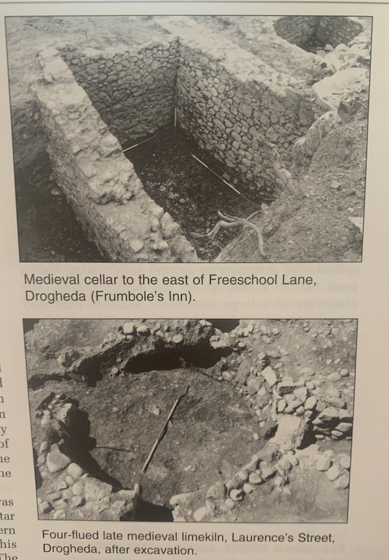
To the south-east of this a second house was exposed, 8.4m long and 6.8m wide. It had a mortar floor, and a hearth was evident in the north-eastern corner of the room. The northern section of this house was destroyed by a large medieval pit. The house was positioned along the western side of a north-south cobbled pathway that directly overlay the natural boulder clay. This pathway was exposed at a depth of 16.419m OD and was 18m long (north-south) and 1.9m wide. A cellar revealed along Freeschool Lane and constructed of substantial stone walls with a battering at the base may be associated with the famed Frumbole’s Inn. It was 4.2m long (east-west), 2.5m wide and 2.9m deep (12.764m OD). Putlog holes were evident in the south face of the northern wall, where a probable stairwell or wooden floor existed.
A second cellar or basement was evident in the north-eastern corner of the Balfour Hall. This structure was medieval in date, measuring 4.2m by 2.5m, and was backfilled before the construction of the Balfour Hall. A corn-drying kiln was exposed in the western part of the site, and a more substantial one was evident in the eastern part. The former measured 3.9m by 2.2m, and the latter measured 3.4m by 1.6m. Burnt animal bone and teeth were recovered from the interior of the structure, which was stone-lined at its eastern end.
North of this kiln a cruciform drystone limekiln of probable 14th-century date was exposed. This structure was quite substantial and consisted of a large circular bowl area with a diameter of 3.4m and four stone-lined flues at the north, south, east and west.
The area to the west of Freeschool Lane was almost devoid of archaeological stratigraphy. A post-medieval cobbled surface measuring 3.1m by 3.5m, together with a stone drain and associated stone well with a diameter of 1m, was exposed over post-medieval garden soil. This layer extended over the largest part of the site and was cut by the foundations of a 19th-century building. The layers sealed a series of late medieval rubbish pits that was excavated into the natural boulder clay. Freeschool Lane, which was 3.4m wide, was destroyed by the construction of an 18th-century culvert that extended in a north-south direction down the centre of the medieval laneway. Further excavation is required in the eastern part of the site in the area that fronts onto Palace Street.