1999:544 - HAGGARDSTOWN, Blackrock, Louth
County: Louth
Site name: HAGGARDSTOWN, Blackrock
Sites and Monuments Record No.: SMR 12:9, 27
Licence number: 99E0683
Author: Finola O'Carroll, CRDS Ltd.
Author/Organisation Address: Unit 4, Dundrum Business Park, Dundrum, Dublin 14.
Site type: Midden, Kiln - corn-drying, Pit and Burnt spread
Period/Dating: Multi-period
ITM: E 707276m, N 802877m
Latitude, Longitude (decimal degrees): 53.964053, -6.365135
Planning permission for a housing development was granted subject to licensed monitoring of soil-stripping. The site consisted of two fields, the long axis of which is north-south. This is a low-lying area, mostly below 15m OD. The ground was highest in the north-west, and there is an area of waterlogged ground along its eastern boundary. A possible souterrain is listed on the site of the development. Jordan (1934) made reference to the removal of stones from an underground passage. Previous testing by Kieran Campbell (Excavations 1994, 64–5, 94E0197; and Campbell 1995) concentrated on the north-west corner and revealed the presence of a roughly circular, ditched enclosure, most likely a ringfort, of c. 40m in outer diameter. No evidence of a souterrain was uncovered at this time. This area, with an additional buffer zone of 15m radius, was excluded from the development.
Monitoring of the soil-stripping of this c. 16-hectare site revealed a number of features of note.
Feature 1 was a substantial shell midden, spoon-shaped in cross-section and irregular, elongated oval in plan, covering a horizontal area of at least 4m east-west by c. 1.5m north-south and with a maximum depth of 0.2m. There was no burnt material associated with the shells, and underlying the shell-rich lens was a thin layer of fine, water-rolled gravel, suggesting that this feature was a natural marine deposit.
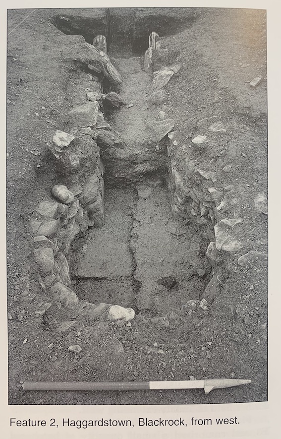
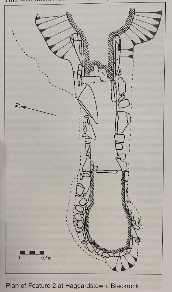
Features 2 and 3 were in the southern part of the site. They were noted first as a spread of burnt soil, with a second, distinct spread 8m to the east of the first. Initial cleaning of the two spreads showed that the burnt soil was contained within two apparently discrete features cut into subsoil. Feature 2, on the west side, was contained in a roughly circular pit c. 2.5m in diameter and 0.6m deep, and Feature 3 was narrower and shallower, c. 1.4m wide, 4.5m long and 0.4m deep. Feature 2 was the ash-pit for a corn-drying kiln that lay immediately to the west of it and ran on the same east-west axis as Features 2 and 3. This was mostly covered by a layer of mid-brown, gravelly clay, which resembled natural boulder clay but was redeposited.
The kiln was of the keyhole type, built of drystone walling, consisting in the main of local sandstone and limestone, with the occasional use of flat slabs of local sandstone as vertical walls and also as lintels, although only two collapsed examples of the latter were present. Its overall length was 4.6m: the circular bowl was 1.1m x 1m and the flue was 3.5m by 0.6m. It survived to a maximum height of 0.65m, with up to seven drystone courses surviving in the bowl. The flue consisted of courses of drystone walling at the western end; at the eastern end the initial 1.45m was occupied by vertical stone slabs resembling small orthostats. These were between 0.5m and 0.58m high. The entire floor of the flue was paved with similar, thin stone slabs. In the eastern end of the flue the floor and wall slabs were heavily fire-damaged, scorched to a dull red colour and shattered through intense heat. The ash-pit lay immediately to the east.
The bowl was floored with marl that was probably derived from the marshy ground to the east. This floor was compacted, was laid directly on the natural gravels and was a maximum of 60mm thick. A similar layer of marl, which also contained stones, overlay it; this appeared to represent collapsed roofing material. There were no deposits of charcoal or charred grain on the floor, and, although some inclusions occurred within the floor material, these are probably not derived from the use of the kiln.
No associated paving was noted such as has occurred in other similar kilns (see Hurley 1997, 22–4; Hurley and Scully 1997, 276–7). This absence of paving may have been due in part to the intensity of the agricultural activities in the area.
The ash-pit immediately to the east of the kiln contained layers of ash and charcoal, although again no deposits of grain were noted. It survived to a maximum diameter of 2.65m on the north-south axis and was 0.56m at its deepest. It included fragments of shells and an upper layer, thickest in the centre, consisting of a mixture of clay with marl in it, beige but with ash and charcoal inclusions.
Feature 3 had the appearance of a shallower and narrower version of the ash-pit with a similar fill. It was 8m to the east of Feature 2 and was noted as a spread of burnt earth 4.5m east-west by 1.3m. It too contained a layer of heavily charcoal-flecked soil, and lenses of orange (burnt) soil containing a high percentage of ash. The lenses containing shells were thicker, and the quantity of shells, principally limpets, was greater in this area. The upper layer in both Features 2 and 3 was a mixture of clay with marl in it, beige but with ash and charcoal inclusions, and this also extended over the corn-drying kiln. This was found to extend to the east and west of these features and had the appearance of a field boundary or drain. To the east it merged into the sandy subsoil, although it was visible in it.
It appears most likely that the kiln and associated pit were inserted into an existing feature, possibly a field boundary, and that debris from the kiln was spread into the ditch. After the kiln ceased to be used, the ditch may have continued in use and then either silted up or was filled in.
The finds recovered came from the upper levels of the features and were possibly associated with the field boundary. A fragment of a post-medieval skillet handle, one rimsherd and one body sherd of post-medieval date, one fragment of Staffordshire slipware and one (broken) rimsherd of earthenware crock with a dull red glaze were recovered. One flint core was also recovered from the ploughsoil overlying the feature. Two unrecognisable iron pieces were noted but not retained.
Feature 7 survived as a lens of charcoal-stained soil up to 50mm thick but on average 20mm thick, overlying the gravel and clay subsoil. It had an irregular shape and was 0.79m in maximum length and 0.52m in maximum width. A number of flint pieces, including a scraper, were recovered from the charcoal-stained soil, as well as a tiny fragment of heavily abraded pottery. In cleaning the adjacent area, a thin skin of unburnt soil overlying gravel, a further three pieces of struck flint were recovered. Again, one of these, a small side scraper, was worked. Unfortunately, no other features survived in the vicinity of Feature 7. Although it was directly overlying subsoil, and the topsoil in the immediate area was a minimum of 0.5m thick and a possible maximum of 1m thick, it is impossible to say whether it was the base of a cut feature. Alternatively, it may indicate human activity in the area before the development of the considerable depth of topsoil. The field had been extensively and deeply ploughed, and the subsequent activity involving heavy machinery had entirely obliterated any other detail.
Feature 8 comprises a number of features identified over an area of c. 50m north-south by 30m east-west, on the east-facing slope of the slight hill immediately below the ringfort investigated by Campbell. Approximately 0.5m of topsoil was removed.
The area was assessed by systematically walking through it both north-south and east-west. Thirteen individual features were identified, and many incidences of bone, shells, charcoal and other material were recorded. Planning permission has not been obtained for building within this area, so the features were not disturbed.
The soil in this area is varied but in general is dark brown, water-saturated and dense; it is visibly distinct from the soil in the remainder of the development, which is lighter in colour and less water-saturated. The area has been truncated to the east and north by the construction of the roads for the development. Soil has been removed from the northern end and added to the east in the construction of these roads. There has been extensive ploughing in the area, the most recent phase relating to potato crops, and the furrows ran approximately north-south.
There is a central zone that is in line with the possible entrance to the ringfort as described by Campbell (1995). The concentration of archaeological material within it is significantly denser than that in the remainder of the area. This is c. 30m wide (north-south) and runs down the slope of the hill to the east for c. 30m.
Soil-stripping in the area to the south-east of the ringfort and immediately south of Feature 8 uncovered a zone of soil (Feature 9) that in general is dark brown and visibly distinct from the soil in the remainder of the development. The brown soil was charcoal-flecked and had a high clay content, containing grit and some gravel, and it proved to be confined to a band running east-west down the slope, roughly 18m long and 2.5m wide, though irregular in shape. Four sherds of post-medieval pottery were recovered from this feature, as well as one piece of slag.
The feature appears to have been an early field boundary, consisting of a bank containing stones or a stone facing, and possibly an associated shallow ditch. The latter feature, represented by a shallow scoop into the natural, may simply have been the surviving portion of the area dug out to create the bank, which may then have been capped with stones. The intermittent nature of the stones, and the occasionally inverted soil profile where the brown, charcoal-flecked soil was covered by redeposited natural, appears to have been caused by deep ploughing.
On the western end of the field boundary a narrow gully running roughly north-south was noted. This was 1.75m long, between 0.15m and 0.2m wide and 50mm deep. It was filled with a brown, wet, sterile soil, which did not contain any charcoal. No finds were recovered from it. It had the appearance of a possible furrow that may have related to the field boundary described above.
Feature 10, in the north-west area of the northern field, was a spread of burnt soil contained in a pit 1.3m long, running roughly east-west, and 1m in maximum width. The pit was 0.2m deep and was filled with a dark, loamy soil containing burnt stones. There was an extension to the west end of the pit that was 0.4m wide and 0.8m long. The sides of the cut for this feature were steeper than for the pit, and the western end was very straight. It had a layer, 50mm thick, of the dark, loamy soil overlying a fill 0.12m deep of burnt soil that was reddish-brown. It had the general appearance of a flue. No finds were recovered from this feature, and no other features were noted during the soil-stripping in its vicinity. However, the topsoil in this area was c. 0.2m deep, and again plough damage may have removed any associated features not cut into subsoil.
Feature 11 was also a pit cut into subsoil containing burnt stones in a matrix of reddish, burnt soil. The pit was 1.1m east-west by 0.64m. It had a maximum depth of 0.24m. The sides were quite steep, although it was quite irregular in shape. No finds were recovered, and there was no layer of dark soil as occurred in Feature 10. No other features were noted in its vicinity.
In summary, monitoring resulted in the identification of eight archaeological features or spreads of features. Seven of these were in areas directly affected by the proposed development, and these were examined and recorded. Feature 8, a complex of features to the east of the ringfort, was in an area omitted from the developer’s planning permission.
Apart from Features 2 and 3 (the corn-drying kiln) and Features 8 and 9 (the complexes of features to the east of the ringfort), the remaining features are quite enigmatic. The time span over which there was human activity on the site is possibly of the order of 4500 years, or longer.
References
Campbell, K. 1995 Archaeological report on site investigations at Haggardstown, Dundalk, Co. Louth.
Hurley, M.F. 1997 Excavations at the North Gate, Cork, 1994. Cork
Hurley, M.F. and Scully, O.M.B. 1997 Late Viking Age and medieval Waterford: Excavations 1986–92. Waterford.
Jordan, J. 1934 Townland of Haggardstown. County Louth Archaeological Journal 8, 210–14.