1999:522 - LIMERICK: Sir Harry's Mall/Long Lane/Fish Lane (Site K.I.16), Limerick
County: Limerick
Site name: LIMERICK: Sir Harry's Mall/Long Lane/Fish Lane (Site K.I.16)
Sites and Monuments Record No.: SMR 5:17 (part of)
Licence number: 99E0433
Author: Celie O Rahilly, Limerick Corporation
Author/Organisation Address: City Hall, Limerick
Site type: Historic town
Period/Dating: Multi-period
ITM: E 557354m, N 657614m
Latitude, Longitude (decimal degrees): 52.668020, -8.630498
This site was at the south-eastern end of the area known as the King’s Island/Englishtown, within the zone of archaeological potential for Limerick City as defined on both the Recorded Monuments Map and the Urban Archaeology Survey. It was defined to the north by Long Lane, to the east by Sir Harry’s Mall/Abbey River, to the south by Fish Lane and to the west by the new Northern Relief Road. Both Long Lane and Fish Lane were of medieval origin.
This work was carried out in December 1999 before proposed construction, in order to identify the archaeological implications of the site, which, for development purposes, includes the area south of Fish Lane (partially excavated previously by Kenneth Hanley, see Excavations 1997, 118–20, 96E0334). As yet, there has been no planning application/permission. Any proposed development will impinge on known structural archaeological remains and is also likely to affect deposits. The identification of these would allow the implementation of a proper mitigation strategy at the design stage. It should be noted that this work involved the clearance of 1–1.5m of late fill, which was sufficient to expose the features described below.
The 1840 OS plan shows that a small part of this site, east of Sheep Street and north of Fish Lane, was partly within the walled area of the medieval town. The area between the town wall and Long Lane was possibly part of St Francis’s Friary. The area east of the wall was likely to have been the bank of the Abbey River, and it was not until it was reclaimed, in around the 1770s, that it was developed. Number 16 Sir Harry’s Mall is possibly the only original structure from this time that survived to the recent past.
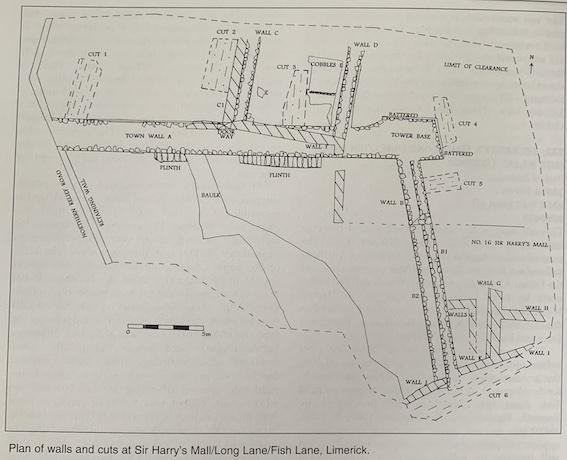
The town wall, encountered during monitoring for the Northern Relief Road (Excavations 1996, 70–1, 96E0213), was exposed heading eastwards (Wall A) and then southwards to Fish Lane (Wall B). Also exposed, abutting the outside face of the town wall, were two walls, C and D, and an associated area of cobbling, E. Possibly associated with these walls was a portion of a wall, F, found directly on Wall A. Six shallow cuttings were made, owing to the flooding.
Work commenced to the west of the site, where Wall A was exposed just below the existing surface. It extended west-east for 25.5m, parallel to but south of Long Lane (4.75–3.96m OD). This wall was a continuation of the 2m-wide wall identified further west, below the Northern Relief Road, where the external face was exposed to a height of 2.5m. It extended south-east from the Gaol Lane/Long Lane intersection. Its internal face was found flush with the northern edge of Sheep Street. Wall A maintained its width of 2m as far as the eastern end, where it terminated with a very well-defined projection, battered on the northern and eastern sides, which represented the remains of the base of a corner tower (4.43–3.4m OD). The presence of a corner tower in this location is confirmed by the representations on the various early maps of Limerick.
At the western end the upper courses of the external face of Wall A had been removed by the insertion of a later wall. Judging from the cartographic evidence, this insert can be dated to the early 19th century. There was also evidence to suggest that, further east, there was some rebuilding of the upper courses, but the internal face would appear to be original. Under the Northern Relief Road the exposed external face rested on a plinth found 2.7m below the exposed top. On the internal face, however, the plinth occurred at 0.6m below the top, at 4.697m OD. There was a distinct difference between above and below the plinth: above consisted of close-fitting, evenly faced, well-cut blocks; below was formed with roughly faced, randomly coursed, ill-fitting stones. Towards the eastern end, Wall A was 1.55m of similarly faced wall above the footing (or plinth?). This occurred at c. 2.41m OD. It would appear, therefore, that the town wall followed a downslope from west to east, as presumably the plinth or footing would have occurred below the ground level as it existed at the time of its construction. There is no evidence, so far, for a precise construction date for the town wall in this part of the Englishtown. There were grants of land ‘within/below’ and ‘without’ the walls of Limerick in 1198 (Lenihan 1866, 48), and in 1237 ‘a toll was granted for the purpose of enclosing the city with a wall’ (Lenihan 1866, 53).
Extending southwards for 15.7m from Wall A’s internal face (just west of the remains of the corner tower) a second wall, Wall B, aligned north-south, was exposed (3.92–3.66m OD). At the northern edge of Fish Lane it terminated with a finished end, which may represent the side of a simple arched gate, on the lane. Though narrower and of a different build, it appeared to be bonded to the masonry of the internal face of Wall A. This difference may be the result of either the town wall having been built in stages or Wall B being a precinct wall for the Priory of the Fratres Cruciferi, or Crutched Friars. The exact foundation date for this is not known, but it was mentioned in the Pipe Rolls for 1211–12 (Hodkinson 1990, 41) and is listed in Gwynn and Hadcock (1988, 210) as founded before 1216. This wall aligned with a small section of wall exposed at a low level on the site south of Fish Lane (Excavations 1997, 118–20, 96E334, Cutting 2A, Phase 1). Here, also, the southern limit of the walled town was identified by another wall, at a higher level, running east-west parallel to, but just south of, Little Fish Lane.
The external face of Wall B was, judging from its masonry, of a single build. However, it had its own separate internal face, B1, positioned approximately central to the core. This face extended from Fish Lane north to where the north wall of No. 16 Sir Harry’s Mall crossed Wall B. North of this point the internal face appeared to be of a different build, bearing a closer resemblance to the lower internal face, B2. There was what appeared to be a secondary spread of unfaced masonry at the northern end. This obscured the upper internal face, but its line can be seen to continue behind it.
If, as suggested above, the ground level at the time of the construction of the town wall dropped, the original external facing of Wall B1 may not have been exposed by the present work. Alternatively, it is possible that the two parts of the wall, B1 and B2, are the result of later modification, possibly relating to the presence, in the angle of the town wall, of the two houses described in the Civil Survey of 1654. These could have been built after the Dissolution (1537) and the laicisation of the priory.
Externally abutting Wall A, two apparently contemporary parallel walls, C and D, were exposed heading northwards (4.23–3.9m OD) for c. 4.8m but were not fully cleared of the overburden of late fill. They were similar in construction and dimensions. Abutting the west face of Wall C was a second wall, C1, of a later build. As the location of C and D did not correspond with any walls or lanes on the OS maps, they may be earlier; it is possible that they are the side-walls of a building depicted on the 1590 map in this location. This was apparently associated with St Francis’s Friary. Their association, if any, with Wall F, on top of (and overhanging) Wall A, needs to be clarified. This may be the southern gable of this structure.
An area of cobbling, E (c. 3.65m OD), was exposed west of Wall D, just below the level of its plinth. This had an east-west line defined by larger, rectangular cobbles. As there was no cartographic evidence for a lane in this location, it would appear to be reasonable to identify it as a floor, but this can only be confirmed by excavation. The southern end of the cobbled surface was disturbed by a trench, noted in the section of Cut 3, extending east-west, parallel to the town wall. Again, only by excavation will it be possible to determine the relationship of this trench with Wall A and the cobbles, but it may be related to the rebuilding of the external face.
No structural remains were identified internal to the town wall, and the only area where the fill was reduced to a possible medieval horizon (2.02m OD) was along the internal face of Wall A, where it had been defaced.
There was a complex of connecting walls north of Fish Lane, some or all of which are likely to be related to the house fronting the Mall, No. 16. Three of these, G, H and I, formed a cellar; two more, J and K, defined the northern edge of the lane; and the third, L, was a three-sided structure abutting Wall B1 externally (3.83–3.25m OD). The cellar’s western wall, G, had an impressive external batter and extended northward beyond the northern wall of the cellar, H. Similarly battered walls, dating to the 18th century, were identified by K. Hanley (pers. comm.) on the site to the south. Also possibly associated with this building was the three-sided structure, L. Judging by its poor construction, this was not a substantial structure and may have been either a latrine or some kind of garden feature. The northern boundary wall of No. 16, removed during the clearance, crossed Wall B. As noted above, there appeared to be a change in the internal facing of Wall B1 north of the crossing-point. At its western end this boundary wall angled northwards, and then turned west on Wall A. The section of in situ Wall F here was left in order to clarify its relationship with Walls C and D, the two parallel walls mentioned above. At its eastern end, Wall D aligned exactly with the return aligned north-south. At the western end Wall C was aligned with the vertical line of blockwork, with every second stone recessed as if there had been a return northwards. Beyond this line the remainder of Wall F was definitely later.
Two walls, J and K, appear to have been inserted to define the northern side of Fish Lane or may be the foundations for buildings or property boundaries part-fronting the lane. Their exact date of construction is uncertain; they were definitely in place in the early 19th century but may be earlier. Also exposed on both sides of the town wall were other foundations identified on the 19th-century OS plans.
Cut 1 was at right angles to the external face of Wall A, near the Northern Relief Road. It was 4m long, 1.5m wide and 0.8m deep (the level of the blue-grey clay), at which point flooding occurred, 1.85m from the top of the town wall. The exposed height of Wall A was 1m of faced stones, with 0.9m of defaced wall core. The fills visible in the western section were all semi-modern; the pottery recovered was 18th/19th-century brownware and glazed red earthenware.
Cut 2 was dug parallel to the western side of Wall C1, abutting the external face of Wall A, 2.2m from it, in order to determine the depth of foundations of Wall C1. Only the western face of this wall was exposed, as its eastern face was built against the western side of Wall C, the possible Friary-related structure. This cut was 2.5m long and 1.75m wide. The base of Wall C rested on late fills.
Cut 3 was opened between Walls C and D, the two parallel walls abutting the external face of Wall A, 2.15m east of Wall C and 1.8m west of Wall D. It was 2.1m long, 1.2m wide and 0.9m deep. A possible trench, cut parallel to Wall A, was identified. In the eastern section this was against the face of Wall A, but in the western section the cut was further north. The fills varied in both but, judging by the amount of brick etc., still appeared to be late.
Cut 4 was parallel to the eastern end of the corner tower of Wall A. It measured 2.7m north-south by 0.9m by a maximum depth of 0.35m. The fill consisted of a mixed debris with sand and brick and may have been a form of reclamation fill.
Cut 5 was dug at right angles to Wall B1, 1.25m south of the tower. It was opened in order to determine the depth of the face of the wall, but flooding occurred almost immediately. It measured 2.1m east-west by 1.1m. The fill was identical to that in Cut 4.
Cut 6 was dug in Fish Lane, parallel to the walls defining its edge, Walls I, J and K. At the west end, below tarmac and hardcore, a double layer of cobbles was visible in the northern section only. Below this was late demolition rubble, not the original lane stratigraphy. At the eastern end mixed debris overlay a thick layer of pure, grey/brown clay.
The presence of the layer of dense, pure clay may explain the lack of original stratigraphy in Fish Lane; this was the same thick, dense clay layer identified on both the adjacent sites that appears to have been deposited as an impermeable layer to lessen the effects of the tidal flooding before the development of this area in the 18th century. South of Fish Lane it pre-dated the houses constructed by Sir Harry Hartstonge, c. 1777. Presumably the ground level in this area was reduced, the town wall destroyed and clay put in place. ‘Sir Harry Hartstonge…made an embankment at Sluice Island, at a great outlay of money, and built a mall, and several fine houses, which, being without the walls, were free at the time from Corporate claims, or other city taxes…[c]alled sir Harry’s Mall—now gone to complete ruin—the site of its fine houses utterly neglected’ (Lenihan 1866, 368–9). It is now known that the houses on Sir Harry’s Mall were built not ‘outside the town wall’ but partly over it (Excavations 1997, 118–20, 96E0334).
The cartographic evidence shows the gradual expansion, after the mid-18th century, of the town beyond the limits of the town wall. Before this, while there is evidence for dwellings external to the wall, the wall itself remained functional and its line was respected. After this it can be seen that the areas external to the wall, to the south and east of the site, were being reclaimed and built on. By about 1786 even the wall seems to have been omitted south of Fish Lane and along the southern side of the site, and it was also cut through by the lane leading north to the County Court House and Hospital located on the site of the friary.
By the 19th century there was extensive development along the southern side of Long Lane, but the area in the angle, internal to the town wall, remained open until the late 19th century. By this stage the Georgian houses (built in 1777) were gone. The early 20th century saw the maximum development of the site, which situation has remained until recently.
References
Gwynn, A. and Hadcock, R.N. 1988 Medieval religious houses: Ireland. Dublin.
Hodkinson, B.J. 1990 The priory of the Hospital of Sts Mary and Edward, King and Martyr, known as Holy Cross, OSA, near the Bridge of Limerick. NMAJ 32.
Lenihan, M. 1866 Limerick: its history and antiquities, ecclesiastical civil and military. Dublin.