1999:515 - LIMERICK: Broad Street/George's Quay/Abbey River, Limerick
County: Limerick
Site name: LIMERICK: Broad Street/George's Quay/Abbey River
Sites and Monuments Record No.: SMR 5:17
Licence number: 98E0581
Author: Edmond O'Donovan, Margaret Gowen and Co. Ltd.
Author/Organisation Address: 2 Killiney View, Albert Road Lower, Glenageary, Co. Dublin
Site type: Bridge, Historic town and Town defences
Period/Dating: Multi-period
ITM: E 557354m, N 657614m
Latitude, Longitude (decimal degrees): 52.668020, -8.630498
Three cuttings were excavated on George’s Quay and one at Broad Street before construction activity associated with the Limerick Main Drainage Scheme. In addition, a programme of excavation (50 trenches) was initiated in the Abbey River before the first phase of pipe-laying in the riverbed. Phase II of the construction work will see river gravels being investigated for archaeological structures and artefacts at the mouth of the Abbey River at its confluence with the River Shannon and another short programme of land-based excavation in the Potato Market.
George’s Quay
A small excavation, Cutting 1, was carried out on George’s Quay in front of Barrington’s Hospital. The cutting measured 4m east-west by 3.5m and was excavated to a depth of 2.5m below ground level. The trench revealed a sequence of 18th-century reclamation that is likely to be associated with the construction of the existing quay, built in 1760. The current quay was built parallel to, and outside of, the town wall.
The excavation uncovered twelve distinct layers of deposition/reclamation above an 18th-century culvert contemporary with George’s Quay and a later stone culvert cut through it. The town wall was not encountered in this cutting. The excavation was not carried to the base of archaeological deposits because of the limited impact of development in this location.
Cutting 2 was at the junction of George’s Quay and Mary’s Street. The cutting measured 6m east-west by 8.5m and was excavated to a depth of 5m below the existing quay. The excavation was at the junction of the medieval bridge, the town wall and a defensive tower defending the northern end of the bridge on the town wall. The stretch of town wall was 6.8m long and 2.45m wide and stood to a height of 4.45m. The springing arch of the medieval bridge was identified at the easternmost external end of the town wall. A walkway or sconce was identified, behind and inside the town wall. This led to an arched entrance into the tower. No surface trace of the structures was visible above ground level before the excavations.
The historical sources suggest that the medieval defences survived up to 1760, when the present quay was constructed; the bridge was replaced in 1830. No medieval archaeological layers were recorded adjacent to the walls. The layers that abutted the structures were 18th- and 19th-century in date and were deposited as a result of reclamation and quay construction.
A small excavation, Cutting 4, was carried out on George’s Quay at the bottom of Creagh Lane. The cutting measured 9m east-west by between 3.5m and 4.5m and was excavated to a depth of 2.25m below ground level. The trench revealed a similar sequence of 18th-century reclamation to that seen in Cuttings 1 and 2 associated with the construction of the existing quay built in 1760. However, a corner section of mural tower on the town wall was identified along the length of the cutting. The section of town wall was identified 1.3m below the street. The masonry structure was 1.05m wide and extended a further 0.95m beneath the existing road level. Full excavation was not carried out to the base of archaeological deposits as a result of an alteration to the design to the proposed development in response to the archaeological discovery.
Broad Street
Excavations at Broad Street (Cutting 3) uncovered two medieval bridge piers under the junction of Broad Street and Charlotte Quay. These structures formed part of the medieval bridge (on the site of Baal’s Bridge) that formed the vital link between the Irishtown and the Englishtown on King’s Island. When the Anglo-Normans launched their assault on Limerick in 1175 there was no bridge in the location later occupied by Baal’s Bridge. Giraldus Cambrensis records that the attackers found a ford across the Abbey River and he ‘hurled himself headlong into the swiftly flowing river…’ and managed to cross to the opposite bank. It would appear that the bridge linking King’s Island to the mainland to the south, on the site of what is now called Baal’s Bridge, was non-existent when the Anglo-Normans arrived in Limerick in 1175.
The excavations at Broad Street indicated a long archaeological sequence commencing in the mid-13th century up to the present day. The cutting measured 35m east-west by between 5m and excavated to a depth of 5m below the street level. Three samples from oak timbers that revetted one of the bridge piers were submitted for dendrochronological dating (David Brown, The Queen’s University of Belfast). The results suggested that the bridge piers were constructed in the early 13th century.
Organic deposits were identified abutting the bridge piers. Environmental analysis of macrofossil plant and insect remains (by Eileen Reilly and Penny Johnston of Margaret Gowen & Co.) has demonstrated that the deposits around the bridge piers accumulated slowly as a result of the dumping of organic refuse and the accumulation of river silts. The organic deposits originated from natural silting and contemporary settlement in the medieval city during the 13th and 14th centuries. The excavation revealed evidence for the growth and development of Broad Street, with evidence of house floors dating from the 14th/early 15th century built on top of ground reclaimed from the riverbed. This expansion of the Irishtown towards the Abbey River is likely to have been associated with renewed town wall building extending into the Abbey River. The uppermost archaeological deposits in the cutting consisted of post-medieval cobbling, drains and culverts. The medieval bridge was demolished in 1830 before the construction of the current Baal’s Bridge.
Baal’s Bridge
Extensive excavations of the riverbed from Matthew Bridge to Baal’s Bridge have been completed. These involved opening a large cutting under Baal’s Bridge and fifty smaller trenches upstream and downstream of the ford on which the bridge is sited. The river gravels (c. 1m deep) in these locations are rich in archaeological artefacts. While no in situ structures have been uncovered, a large, important and eclectic collection of archaeological objects was found. The trenches were excavated in situ in the riverbed, and the artefacts were recovered layer by layer.
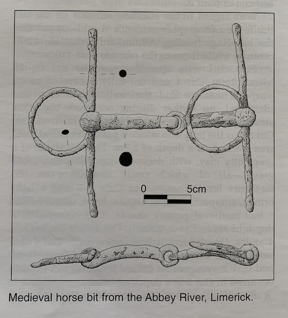
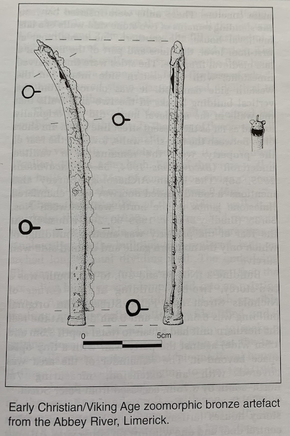
A preliminary summary of the artefacts found includes objects dating from the prehistoric period (worked flint) to the post-medieval period. To date, no Bronze Age objects have been recovered. Several pre-Viking Age artefacts have been recovered, including a possible Iron Age horse bit, an Early Christian bronze zoomorphic object and a spiral-headed pin. A number of Viking Age stick-pins and a coin (c. 1035), minted in London for King Cnut, were also found. Medieval and post-medieval artefacts include beads, coins, horse equipment, pins, brooches, tools and weapons. A small assemblage of locally manufactured and imported medieval pottery has been recovered from the riverbed. Fifty medieval coins dating from 1200 to 1540 have been recovered; they are largely Irish, although Scottish, French and English coins are also included. An early post-medieval (c. 1600) seal bearing the ‘Lymerick Port’ coat of arms was also recovered from the riverbed. Objects dating from the Williamite siege of the city, including iron and stone cannon, musket balls of various sizes, gun flints, spurs, fragments of iron mortar bombs, grenades, iron bayonets and coins (Jacobite gun money), have been retrieved.