1999:324 - BRAY HEAD (Valencia Island), Kerry
County: Kerry
Site name: BRAY HEAD (Valencia Island)
Sites and Monuments Record No.: N/A
Licence number: 97E0278 ext.
Author: Alan Hayden, Archaeological Projects Ltd.
Author/Organisation Address: 25A Eaton Square, Terenure, Dublin 6W
Site type: Enclosure, House - early medieval, Souterrain and Kiln - corn-drying
Period/Dating: Early Medieval (AD 400-AD 1099)
ITM: E 437988m, N 575802m
Latitude, Longitude (decimal degrees): 51.910774, -10.354900
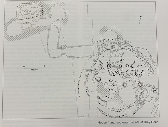
A third and final season of excavation (see Excavations 1997, 81–2, and Excavations 1998, 89, for descriptions of the results of previous season’s work), funded by Dúchas, was undertaken in June and July. Work in 1999 concentrated on the completion of the excavation of Houses 2, 3 and 6, which were partly excavated in 1998. This work revealed the presence of a further two, very poorly preserved round houses, Nos 10 and 11. Excavation of the souterrain attached to House 4, which was discovered in 1998 but could not be excavated at that time, also took place this season.
The souterrain consisted of a short entrance passage, which turned at right angles into a longer passage. The other end of this passage also turned through a right angle and led to a further passage. This may have been the original end of the souterrain. An air vent opened off the end of this passage. The stone-lined passages were all constructed in individual trenches. There were low creeps between the passages that were constructed by tunnelling through the baulks of subsoil left between the individual trenches. The souterrain appears to have been later expanded. A deep spoil pit was dug, and two narrow tunnels led from its base into a large, earth-cut chamber. The tunnels were blocked with stone when the spoil pit was backfilled. The new chamber was linked to the end of the older souterrain by an earth-cut tunnel.
Parts of the roof of one of the souterrain chambers had collapsed. This and the entrance were covered by reinforced concrete beams and large flat stones after the excavation was completed. The stones were covered in polythene, and then the trenches were backfilled and resodded. This will allow the souterrain to be easily reopened if required.
Other work this year involved excavation of an enclosure, discovered this year, which delimited the northern side of the settlement. The intercutting of the successive levels of houses had suggested that the settlement was enclosed. The corn-drying kiln excavated in 1993 (Excavations 1993, 41, 93E0121) lay outside the enclosure. The enclosure consisted of a trench holding upright stones that revetted the downhill side of an earthen bank. It appears to exist only on the northern (uphill) side of the site. A possible entrance was discovered in the north-east side of the enclosure leading to the early medieval routeway known as Bóthar na Scairte, which can be traced along the whole length of the island.
In all, an area measuring a maximum of 30m east-west by 28m has been excavated. The remains of eleven houses—six round (one with a souterrain) and five rectangular—delimited on their uphill side by a stone and earthen bank, with a corn-drying kiln lying outside the enclosure, have been revealed and excavated. There may well be further houses immediately west of those excavated, but no funding is available for further work.