1999:202 - DUBLIN: Iveagh Market, Francis Street, Dublin
County: Dublin
Site name: DUBLIN: Iveagh Market, Francis Street
Sites and Monuments Record No.: N/A
Licence number: 99E0261
Author: Franc Myles for Margaret Gowen & Co. Ltd.
Author/Organisation Address: 2 Killiney View, Albert Road Lower, Glenageary, Co. Dublin
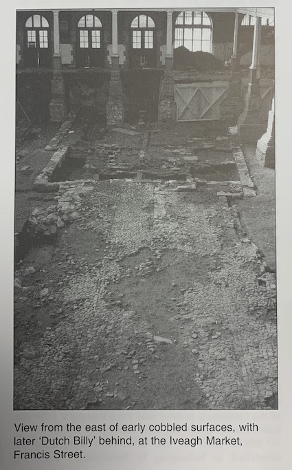
Site type: House - 17th century
Period/Dating: Post Medieval (AD 1600-AD 1750)
ITM: E 714896m, N 733830m
Latitude, Longitude (decimal degrees): 53.342210, -6.274573
Five weeks of survey and excavation was undertaken in the dry goods section of the Iveagh Market, following the exposure of limestone and brick foundations and cobbled surfaces during clearance work. The market was constructed c. 1900, on the site of a disused brewery. It would appear that before the market’s construction the buildings were demolished into their basement spaces and the ground was then levelled and slabbed. The site is to be redeveloped as a market in a joint venture between Dublin Corporation and a private developer.
As the overburden and demolition debris had been removed, it was initially difficult to establish stratigraphical relationships between the structures uncovered. The exposed structures were planned at 1:20 and transferred into AutoCAD. This was transferred onto the current Ordnance Survey plan. The structures were then interpreted on the basis of overlays of the 1836 preliminary manuscript edition of the Ordnance Survey and John Rocque’s 1756 An exact survey of the city and suburbs of Dublin.
While most of the structures can now be identified as belonging to Sweetman’s Brewery, which occupied the site from 1791 until its take-over by Guinness in the 1890s, four structures fronting Francis Street were identified as being the lower ground floors of ‘Dutch Billys’, gable-fronted buildings that were the dominant building type in the Liberties from the late 1600s. The buildings survived in an extended form of those depicted on Rocque’s map, and they appear to have been serviced by sewers that pre-dated their primary phases. The buildings occupied wider plots than those occupied by cobbled yards extending behind the houses to the east. This would indicate that the yards relate to earlier street-front structures that were removed when the ‘Dutch Billys’ were built. John Speed’s Dubline shows buildings on either side of Francis Street in 1610, and it is possible that the cobbled surfaces relate to these structures.
The large buildings depicted on Rocque’s map, between the backyards of the ‘Dutch Billys’ and the line of the medieval city wall, were not evident and were possibly included by Rocque to fill an empty space. Twenty-four samples of bonding mortar and lime render were collected from the buildings and structures identified and will be analysed for composition as part of this phase of recording.
Eight test-trenches were excavated in order to determine the level of natural subsoil and to investigate the depth of the cast-iron columns supporting the market roof. These identified two areas where medieval deposits had not been truncated by later occupation. Two layers of cultivated medieval garden soil were evident in the one surviving earthen section along the northern boundary of the site. This material may be associated with the medieval fair green that was situated to the north of the market. A second area of garden soil in the south-eastern corner of the site sealed refuse pits that contained locally produced medieval pottery. Several areas of subsidence along the southern boundary of the site suggest the possible presence of large pits pre-dating the surviving structures.
Further excavation will take place in the wet market, the site of the medieval city ditch, in 2000.