1999:191 - DUBLIN: 2–4 Coppinger Row, Dublin
County: Dublin
Site name: DUBLIN: 2–4 Coppinger Row
Sites and Monuments Record No.: N/A
Licence number: 99E0285
Author: Daniel Leo Swan, Arch-Tech Ltd.
Author/Organisation Address: 32 Fitzwilliam Place, Dublin 2
Site type: House - 17th/18th century and Well
Period/Dating: Post Medieval (AD 1600-AD 1750)
ITM: E 715748m, N 733815m
Latitude, Longitude (decimal degrees): 53.341892, -6.261787
Monitoring commenced on the site at Nos 2–4 Coppinger Row on 8 July 1999 before an apartment development and continued until 19 August 1999. The site is opposite the southern wall of the Powerscourt Townhouse Centre, one plot to the west of the intersection of Clarendon Street and Coppinger Row and one plot to the east of the Dublin City Assembly House (now housing the Civic Museum).
The site would have been c. 150m to the north-east of the pre-Norse ecclesiastical enclosure that surrounds the church of St Peter del Hulle, St Stephen’s Hospital and the Whitefriars Monastery. From cartographic and historical sources the area appears to have been open ground until the late 17th century, with the earliest depiction of Coppinger Row (then Coppinger Lane) being on Charles Brooking’s map of Dublin, produced in 1728. Howard Clarke’s conjectural superimposition of John Speed’s map of 1610 onto the present Dublin streetscape places the course of the River Steine as running through Nos 2–4 Coppinger Row, dividing the lots of Clarendon Street from those of William Street.
Monitoring was carried out in two phases: (1) monitoring of the boring of 33 pile-holes of 300mm diameter and (2) monitoring of the mechanical excavation of pits for pile caps, lift shaft and crane base, and trenches for ground-beams and services. No archaeological material that could be identified as pre-18th century was uncovered during the monitoring programme. This supports the picture of a late 17th/early 18th-century origin for this part of the city. It should, however, be noted that the site had been cellared over 70% of its area and disturbed by drains from the 18th century onwards, greatly reducing the chances of finding any potential evidence of earlier activity.
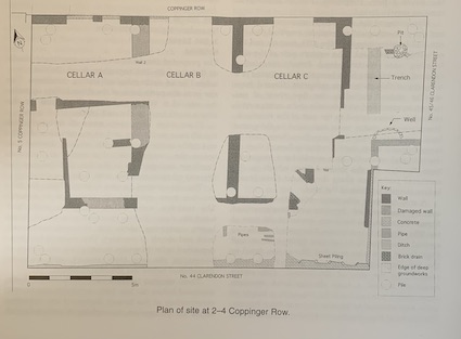
The monitoring programme produced evidence for three cellars, each 4.5m wide and c. 9m long, apparently internally subdivided and cut deeply into natural subsoil. The main cellar walls were composed of coursed rubble stone, 0.5m thick, while internal subdivisions were much thinner and generally composed of brick. The westernmost cellar extends under the street for c. 1m, with a half-arched brick roof accessed through two brick-detailed doorways. While the two eastern cellars may have similar features, these were not identified during the monitoring. The presence of a blocked-up entrance in the northern wall of the middle cellar certainly suggests that this is the case. The western cellar appears to have had access from the rear yard area, where the partially destroyed western corner of a probable doorway was identified.
The current development did not disturb the cellars as far as their bases, except in the pile-holes themselves, but those levels that were exposed had a clear stratigraphy: a lower layer of dark silt and woody material at least 0.75m thick underlay a loose infill of rubble dominated by red brick up to 1.5m thick. This suggests that the cellars were disused and had been accumulating debris for some time before the demolition of the overlying buildings, from which the upper layer of rubble is derived.
The three cellars fit well with the position of Nos 2–4 of the late 18th-century terrace that stood along the south side of Coppinger Row until their dereliction and demolition in the mid-1960s. An open space identified at the south of the site also agrees with this interpretation, and while the 1906 Ordnance Survey 1:1000 map shows an outhouse in each of the three plots, the fact that the 1901 census does not record their presence strongly suggests that they are outside toilets.
An uncellared area at the east of the site, between the east wall of the cellar identified as belonging to No. 2 Coppinger Row and the wall of the present No. 45 Clarendon Street, was occupied by No. 1 Coppinger Row as shown on the 1936 OS 1:1250 map. This building should not be confused with the present No. 1 Coppinger Row, which is part of the Nos 45–46 Clarendon Street building. A number of features survived in the area beneath this building, including a narrow trench and a partially destroyed stone-lined pit at the southern end, probably a well. It is significant that this area of the site is shown as open ground on John Rocque’s map of 1757.
From the absence of any clearly riverine deposits on the site, it must be concluded that the River Steine did not flow through this part of Coppinger Row as had been previously suggested by the depiction on Speed’s map of 1610. However, the identification of a probable well of unknown date at the south-east of the site may be of interest in discussions of the hydrology of this part of the post-medieval city. Given the east-facing slope visible across the site, it may be suggested that the course of the Steine actually ran some distance to the east.